
 |
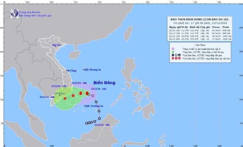
| Location and direction of storm No. 10 on the afternoon of December 23. (Photo: National Center for Hydro-Meteorological Forecasting) |
According to the National Center for Hydro-Meteorological Forecasting, at 1 p.m., the eye of the storm was located at about 11.2 degrees North latitude; 112.4 degrees East longitude, in the northwest area of Truong Sa. The strongest wind near the eye of the storm is level 8 (62-74 km/h), gusting to level 10; the storm is moving in the West-Northwest direction, at a speed of about 10 km/h. The sea area north of the South East Sea (including the north of Truong Sa) and the sea area southwest of the central East Sea has strong winds of level 6-7, the area near the eye of the storm is level 8, gusting to level 10, waves are 4-6m high; the sea is rough.
Forecast from 13:00 on December 23 to 13:00 on December 24, the storm will move in the West-Northwest direction, speed about 5-10km/h, the strongest wind near the storm center is level 8, gusting to level 10. Natural disaster risk level 3. The affected area is the South East Sea (including the North of Truong Sa area), the sea area southwest of the central East Sea.
From 1:00 p.m. on December 24 to 1:00 p.m. on December 25, the storm moved in a West-Southwest direction, at a speed of about 5-10 km/h and gradually weakened into a tropical depression, with the strongest wind near the storm center at level 6, gusting to level 8. Natural disaster risk level 3. The affected area is from Phu Yen to Ba Ria-Vung Tau; the sea southwest of the central East Sea, the sea northwest of the South East Sea (including the northwest of the Truong Sa area).
From 1:00 p.m. on December 25 to 1:00 p.m. on December 26, the tropical depression moved in the West Southwest direction, at a speed of about 10-15 km/h and gradually weakened into a low pressure area.
Due to the impact of the storm, from the night of December 23 to December 25, the area from Da Nang to Khanh Hoa will have moderate rain, heavy rain, locally very heavy rain and thunderstorms with common rainfall from 60-150mm, locally over 250mm. Warning of the risk of local heavy rain over 100mm/6 hours. In addition, from early morning to the night of December 24, the areas of Ninh Thuan, Binh Thuan and the Eastern Central Highlands will have moderate rain and scattered thunderstorms, locally heavy rain with common rainfall from 20-40mm, some places over 80mm.
Warning, from the night of December 25, in the Central Central region, there will be moderate rain, heavy rain, locally very heavy rain and thunderstorms with common rainfall of 20-40mm, locally over 70mm. From December 26, heavy rain is likely to gradually decrease; thunderstorms may cause tornadoes, lightning and strong gusts of wind. Natural disaster risk level due to heavy rain is level 1.
Heavy rain is forecast to cause flooding in low-lying areas; flash floods on small rivers and streams, and landslides on steep slopes./.
Source: https://dangcongsan.vn/xa-hoi/ap-thap-nhiet-doi-manh-len-thanh-bao-so-10-687293.html
![[Photo] Coming to Son La, let's "show off" with the Wallflowers](https://vphoto.vietnam.vn/thumb/1200x675/vietnam/resource/IMAGE/2025/5/21/627a654c41fc4e1a95f3e1c353d0426d)
![[Photo] Scientific workshop "Building a socialist model associated with socialist people in Hai Phong city in the period of 2025-2030 and the following years"](https://vphoto.vietnam.vn/thumb/1200x675/vietnam/resource/IMAGE/2025/5/21/5098e06c813243b1bf5670f9dc20ad0a)

![[Photo] Prime Minister Pham Minh Chinh receives the President of Asia-Pacific region of PowerChina Group](https://vphoto.vietnam.vn/thumb/1200x675/vietnam/resource/IMAGE/2025/5/21/0f4f3c2f997b4fdaa44b60aaac103d91)


Comment (0)