

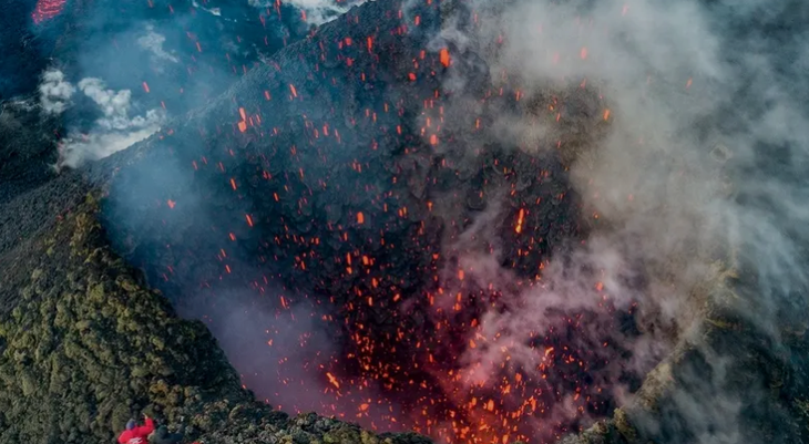
The earthquake on July 30 not only "awakened" volcanoes on the Kamchatka Peninsula, but also caused the peninsula to shift 2 meters southeast - Photo: AFP
According to the Federal Research Center of the United Geophysical Bureau of the Russian Academy of Sciences , preliminary geodynamic data indicates significant ground displacement following the earthquake, particularly evident in the southern part of the peninsula.
The agency assessed that this shift is comparable to the phenomenon that occurred after the earthquake in northeastern Japan in 2011.
Scientists also detected smaller shifts in the area near the city of Petropavlovsk-Kamchatsky.
They stated that the current deformation pattern is consistent with initial fault predictions, which explains why the Severo-Kurilsk region was more severely affected, while other areas experienced less impact.
The Kamchatka Peninsula lies within the Pacific "Ring of Fire"—a region of the world's most active geological formations, where continental plates frequently collide and slide past each other, creating a series of volcanoes and earthquakes.
On July 30th, the area was shaken by an earthquake measuring 8.8 magnitude – considered the strongest since 1952.
The magnitude of this earthquake prompted seismic monitoring centers worldwide to issue warnings and predict that more tremors would follow, potentially lasting for months.
On the morning of August 5th, another earthquake with a magnitude of 6.0 occurred in the area, at a depth of 65km underground and approximately 234km southeast of the city of Petropavlovsk-Kamchatsky.
Although not as intense as the earthquake on July 30th, the occurrence of two major earthquakes in quick succession within just two weeks is causing concern among many people.
Source: https://tuoitre.vn/ban-dao-kamchatka-cua-nga-xe-dich-gan-2m-sau-dong-dat-20250805225249485.htm


![[Image] Pleasant weather helps students enter the 10th grade entrance exam with confidence.](https://vphoto.vietnam.vn/thumb/1200x675/vietnam/resource/IMAGE/2026/05/29/1780034401612_ngay-1-thi-lop-10-minh-duy-8-5009-jpg.webp)
![[Photo] Ba Lang An Lighthouse - the "eye of the sea" amidst the "rock museum" of Quang Ngai province.](https://vphoto.vietnam.vn/thumb/1200x675/vietnam/resource/IMAGE/2026/05/29/1780038698840_anh-man-hinh-2026-05-29-luc-14-10-42.png)







![[GALLERY] The million-dollar 007 blockbuster is causing a sensation on Steam, is it worth buying?](https://vphoto.vietnam.vn/thumb/402x226/vietnam/resource/IMAGE/2026/05/29/1780064112088_ta-2-png.webp)














































































Comment (0)