
Typhoon Kalmaegi is currently at level 9 and will enter the East Sea on November 5. It is forecasted to be a strong storm that will quickly intensify.
The National Center for Hydro-Meteorological Forecasting said that there is an active storm in the sea east of the central Philippines, international name is Kalmaegi.
At 4 p.m., the center of the storm was at about 11.2 degrees North latitude; 132.5 degrees East longitude. The strongest wind near the center of the storm was level 9 (75-88 km/h), gusting to level 11, moving quickly to the West at a speed of about 25 km/h.
Forecast for the next 24 hours, Typhoon Kalmaegi in the sea east of central Philippines, moving mainly west, about 20km per hour, likely to strengthen to level 11-12 intensity, gusting to level 15.
At around 4pm on November 4, typhoon Kalmaegi in the West Central region (Philippines) changed direction to West Northwest, speed 20-25 km/h. The strongest wind near the storm center was level 12, gusting to level 15.
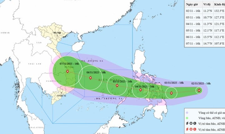
At 4:00 p.m. on November 5, the storm entered the central East Sea, becoming a typhoon. storm number 13 In 2025, the storm will operate in this sea area, moving slowly in the West Northwest direction at a speed of about 15km/h, and may strengthen, with intensity of level 13, gusts of level 16-17.
From the next 72 to 120 hours, the storm will move mainly in the West Northwest direction, with a fast speed again, about 25km per hour and the intensity is likely to increase.
Impact of storm Kalmaegi, from the afternoon and night of November 4, the eastern sea area in the central East Sea will have winds gradually increasing to level 6-7, then increasing to level 8-9; the area near the storm center will have strong winds of level 10-12, gusting to level 14-15, waves 5-7m high, and rough seas.
During November 5-6, the central East Sea area (including Truong Sa special zone), the sea area off the coast of Da Nang - Khanh Hoa is likely to be affected by strong winds of level 12-14, gusts above level 17, waves 8-10m high, and rough seas.
Also according to the meteorological agency, in November 2025, there is a possibility of 2-3 storms and tropical depressions appearing in the East Sea, with the possibility of affecting Vietnam's mainland from 1-2 storms (the average for many years in the East Sea is 1.5 storms, making landfall in Vietnam is 0.9 storms).
During the forecast period, provinces from Ha Tinh to Dak Lak and Khanh Hoa may experience widespread heavy rains. The West of Lam Dong province and the Southern region will have many days of showers and thunderstorms, of which some days may have moderate to heavy rain.
Nationwide there is a risk of dangerous weather phenomena such as thunderstorms, tornadoes, lightning, hail and strong gusts of wind.
Source: https://baolangson.vn/bao-kalmaegi-cap-9-sap-di-vao-bien-dong-du-bao-tang-cap-nhanh-5063690.html
![[Photo] Lam Dong: Close-up of illegal lake with broken wall](https://vphoto.vietnam.vn/thumb/1200x675/vietnam/resource/IMAGE/2025/11/03/1762166057849_a5018a8dcbd5478b1ec4-jpg.webp)


![[Photo] Fall Fair 2025 and impressive records](https://vphoto.vietnam.vn/thumb/1200x675/vietnam/resource/IMAGE/2025/11/03/1762180761230_ndo_br_tk-hcmt-15-jpg.webp)
![[Photo] Prime Minister Pham Minh Chinh receives the Chairman of the Japan-Vietnam Friendship Association in the Kansai region](https://vphoto.vietnam.vn/thumb/1200x675/vietnam/resource/IMAGE/2025/11/03/1762176259003_ndo_br_dsc-9224-jpg.webp)
![[Photo] General Secretary To Lam receives Singaporean Ambassador Jaya Ratnam](https://vphoto.vietnam.vn/thumb/1200x675/vietnam/resource/IMAGE/2025/11/03/1762171461424_a1-bnd-5309-9100-jpg.webp)


Comment (0)