
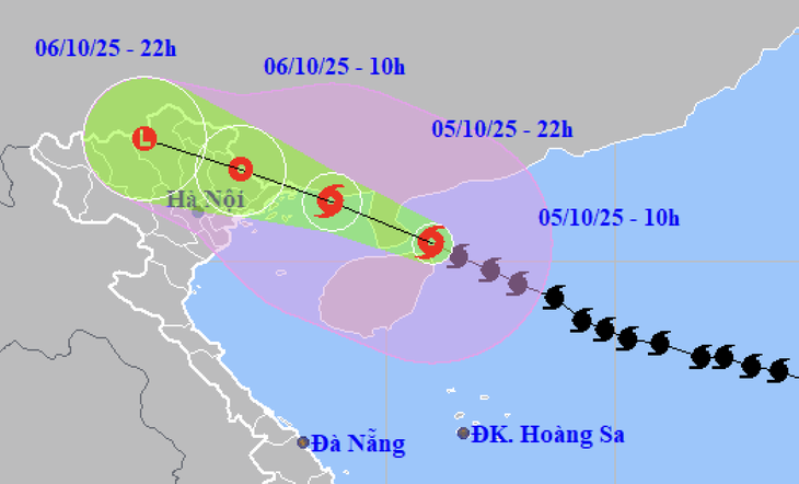
Forecast of location and direction of storm Matmo at 10am on October 5 - Photo: NCHMF
According to the National Center for Hydro-Meteorological Forecasting at 11:00 a.m. on October 5, the center of storm Matmo was about 335km east-southeast of Mong Cai ( Quang Ninh ).
The strongest wind near the storm center is level 12-13 (118-149km/h), gusting to level 16.
From tonight, storm Matmo begins to affect
It is forecast that this afternoon to evening, Typhoon Matmo will sweep across the Leizhou Peninsula. This evening to evening, the storm will enter the Gulf of Tonkin.
It is forecasted that from the night of October 5 to noon of October 6, storm Matmo will affect coastal areas from Quang Ninh to Hung Yen and Lang Son province.
Coastal areas have winds gradually increasing to level 6-7, near the storm center level 8-10 (62-102km/h), gusting to level 11-12.
The inland area of the Northeast has strong winds of level 6, gusting to level 7-8.
Communes and wards in the northeastern region of Quang Ninh province have strong winds of level 9-10 (75-102km/h), gusting to level 12-13 - a wind level that can break tree branches, blow off roofs and cause damage to houses.
The remaining communes and wards of Quang Ninh province and coastal areas of Hai Phong have strong winds of level 8-9 (62-888km/h), gusts of level 10-11.
Coastal communes of Hung Yen province and northern border communes of Lang Son province have strong winds of level 6-8, gusting to level 9-10.
The northeastern area of Bac Ninh province (the northeastern area of the old Bac Giang province) has strong winds of level 6-7, gusting to level 8-9.
Proactively let students and workers take time off from school and work
To proactively respond to storm Matmo and the combination of many types of natural disasters such as strong winds, thunderstorms, tornadoes, heavy rains and floods occurring before, during and after the storm, on the morning of October 5, the National Steering Committee for Civil Defense requested that the Northern provinces and cities inform people about the scope and intensity of the storm so that they can proactively prevent it, avoiding the subjective mentality that when storm Matmo makes landfall, it will weaken and will not cause strong winds similar to the recent storm Ragasa (storm No. 9).
Implement measures to ensure safety of people, vehicles, and property for activities at sea, on islands, and in coastal areas, especially tourism activities in the Gulf of Tonkin.
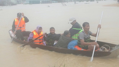
Organize the evacuation of households in dangerous areas, especially weak houses in areas with strong winds, low-lying areas, areas at high risk of landslides, flash floods, and deep flooding to safe places and relocate people in cages, aquaculture huts along the coast, at sea, and on islands.
Continue to check, call and guide ships still operating at sea to move out of dangerous areas or to shelters to ensure safety.
Closely manage boats at anchorage, absolutely do not allow people to stay on the boat during the storm and do not return to the boat until safety is ensured, to avoid unfortunate human losses.
Based on the actual situation, proactively decide to let students stay home from school, and workers in industrial parks and businesses stay home from work in key areas forecast to have strong winds, heavy rains, and floods.
Urgently complete tree pruning, bracing, and reinforcing houses. Implement measures to ensure safety for warehouses, headquarters, public works, industrial zones, mines, mineral exploitation areas, factories, power grids, and telecommunications systems.
Prepare plans for drainage, flood prevention, agricultural production protection, and clearing of blockages and flood drainage, and operating drainage systems for industrial parks, urban areas, and residential areas.
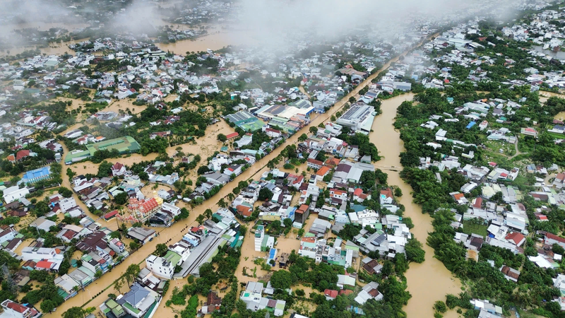
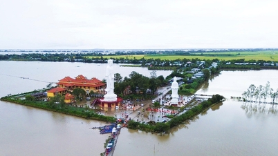
Floods on many rivers may reach level 3, risk of flooding
It is forecasted that from tonight to October 9, on rivers in the Northern region, Thanh Hoa, there is a possibility of a flood, with flood amplitude in the upper reaches of rivers from 4-8m, and in the lower reaches of rivers from 2-5m.
During this flood, flood peaks on rivers in Quang Ninh, Lang Son, Cao Bang provinces. Flood peaks on Thao River, Chay River (Lao Cai), Hoang Long River (Ninh Binh), Lo River (Tuyen Quang), Thai Binh River system (Thai Nguyen, Bac Ninh, Hai Phong) and small rivers reached alert level 2 - alert level 3 and above alert level 3.
High risk of flooding in low-lying areas along rivers and urban areas in the Northern region and Thanh Hoa.
Source: https://tuoitre.vn/bao-matmo-khi-do-bo-kha-nang-gay-gio-giat-cap-12-13-can-tranh-tam-ly-chu-quan-20251005113351689.htm


Comment (0)