
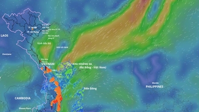
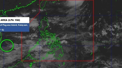
The National Center for Hydro-Meteorological Forecasting said that storm No. 9 Ragasa has weakened into a tropical depression. At 10:00 a.m. on September 25, the center of the tropical depression was about 40km east of Mong Cai ( Quang Ninh ). The strongest wind near the center of the tropical depression was level 7 (50-61km/h), gusting to level 9.
Forecast in the next 3 hours, the tropical depression will move west, speed about 15-20km/h.

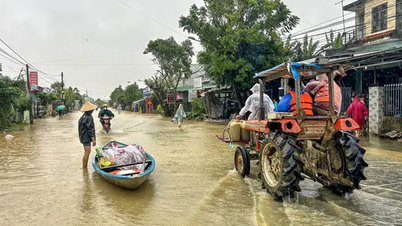
The impact of storm No. 9 Ragasa weakened into a tropical depression, from the morning of September 25 to the night of September 26, the North, Thanh Hoa and Nghe An will have heavy to very heavy rain, with common rainfall of 100-200mm, locally over 300mm. The meteorological agency especially warned of the risk of heavy rain in a short period of time with rainfall exceeding 100mm in just 3 hours, posing a potential risk of natural disasters.
From September 27, heavy rain in these areas gradually decreased.
In addition, in the afternoon and evening of September 25, the Central Highlands and the South will have scattered showers and thunderstorms with rainfall ranging from 15-30mm, with some places experiencing heavy rain over 70mm.
During thunderstorms, be on guard against extreme weather phenomena such as tornadoes, lightning, hail and strong winds, which can affect people's lives, production and travel.
The meteorological agency also issued a storm and flood warning bulletin on rivers in the North and Thanh Hoa from now until September 27, with flood levels rising 3-5m in the upper reaches of rivers and 1-3m in the lower reaches of rivers.
During this flood, the flood peak on Thao River, Lo River, upstream Thai Binh River, Hoang Long River, Buoi River, upstream Ma River reached alarm level 1-2; some small rivers rose above level 2; the flood peak in the downstream Red River - Thai Binh River, Ma River was below level 1.
There is a high risk of flooding in low-lying areas along rivers and urban areas in the Northern region and Thanh Hoa; flash floods and landslides on steep slopes in mountainous areas in the Northern region and Thanh Hoa.
Source: https://baolaocai.vn/bao-ragasa-suy-yeu-thanh-ap-thap-nhiet-doi-mien-bac-mua-lon-den-dem-mai-post882887.html

![[Photo] Prime Minister Pham Minh Chinh meets with representatives of outstanding teachers](https://vphoto.vietnam.vn/thumb/1200x675/vietnam/resource/IMAGE/2025/11/15/1763215934276_dsc-0578-jpg.webp)
![[Photo] Panorama of the 2025 Community Action Awards Final Round](https://vphoto.vietnam.vn/thumb/1200x675/vietnam/resource/IMAGE/2025/11/15/1763206932975_chi-7868-jpg.webp)
![[Photo] General Secretary To Lam receives Vice President of Luxshare-ICT Group (China)](https://vphoto.vietnam.vn/thumb/1200x675/vietnam/resource/IMAGE/2025/11/15/1763211137119_a1-bnd-7809-8939-jpg.webp)


Comment (0)