
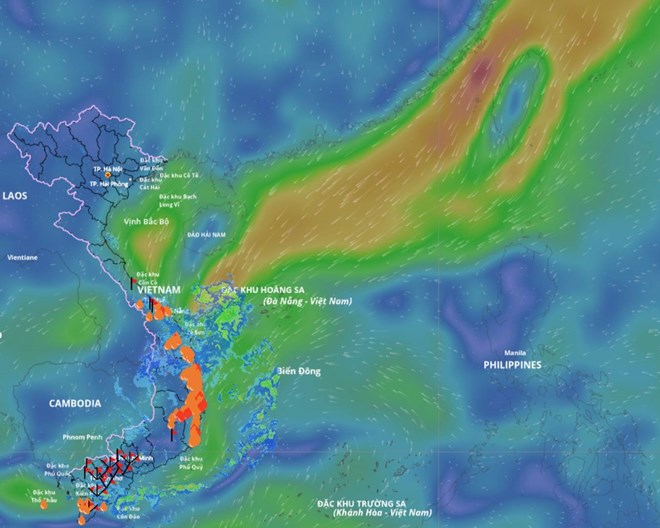
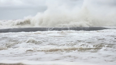
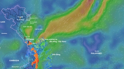
The low pressure area in the East Sea connects with the low pressure trough causing strong winds and big waves in some sea areas. Photo source: Vietnam Natural Disaster Monitoring System
According to the National Center for Hydro-Meteorological Forecasting, Bach Long Vi monitoring station has strong northeast winds of level 6, gusting to level 7; Ly Son station has strong north winds of level 6, gusting to level 7.
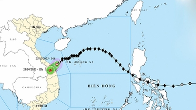
Currently, the low pressure trough has an axis at about 6 - 9 degrees north latitude connecting with the low pressure area in the central East Sea. At 13:00 on October 25, the low pressure area was located at about 10.5 - 11.5 degrees north latitude, 110.5 - 111.5 degrees east longitude.
During the night of October 25 and October 26 , the northern part of the North East Sea will have strong northeast winds of level 6, sometimes level 7, gusting to level 8-9, rough seas, and waves 3-5 m high.
The sea area from South Quang Tri to Da Nang city has strong northeast wind at level 5, sometimes level 6, gusting to level 7-8, rough sea, waves 2-4 m high. The Gulf of Tonkin has strong northeast wind at level 5, from early morning on October 26 increasing to level 6, gusting to level 7-8, rough sea, waves 1.5-3 m high.
The sea area from Quang Tri to Ca Mau, from Ca Mau to An Giang , the Gulf of Thailand, the sea area south of the North East Sea (including Hoang Sa special zone), the area between the East Sea and the South East Sea (including Truong Sa special zone) will have scattered showers and thunderstorms; during thunderstorms there is a possibility of tornadoes, strong gusts of wind of level 6 - 7 and waves over 2 m high.
On the night of October 26 and October 27 , the sea area north of the North East Sea has strong northeast winds of level 6, sometimes level 7, gusting to level 8 - 9, rough seas, waves 3 - 5 m high.
The Gulf of Tonkin has strong northeast winds of level 6, gusting to level 7-8, rough seas, and waves 1.5-3.0 m high. The sea area from South Quang Tri to Da Nang city has strong northeast winds of level 5, sometimes level 6, gusting to level 7, rough seas, and waves 2-4 m high.
The maritime disaster risk warning level is level 2. All vessels operating in the above areas are at high risk of being affected by strong winds and large waves.
Laodong.vn
Source: https://laodong.vn/moi-truong/xuat-hien-vung-ap-thap-moi-tren-bien-dong-du-bao-dien-bien-thoi-tiet-xau-1597967.ldo

![[Photo] Prime Minister Pham Minh Chinh and United Nations Secretary-General Antonio Guterres attend the Press Conference of the Hanoi Convention Signing Ceremony](https://vphoto.vietnam.vn/thumb/1200x675/vietnam/resource/IMAGE/2025/10/25/1761391413866_conguoctt-jpg.webp)
![[Photo] National Assembly Chairman Tran Thanh Man receives United Nations Secretary-General Antonio Guterres](https://vphoto.vietnam.vn/thumb/1200x675/vietnam/resource/IMAGE/2025/10/25/1761390815792_ctqh-jpg.webp)
![[Photo] Prime Minister Pham Minh Chinh receives United Nations Secretary-General Antonio Guterres](https://vphoto.vietnam.vn/thumb/1200x675/vietnam/resource/IMAGE/2025/10/25/1761390212729_dsc-1484-jpg.webp)


![[Photo] General Secretary To Lam meets with General Secretary and President of Laos Thongloun Sisoulith](https://vphoto.vietnam.vn/thumb/1200x675/vietnam/resource/IMAGE/2025/10/25/1761380913135_a1-bnd-4751-1374-7632-jpg.webp)


Comment (0)