
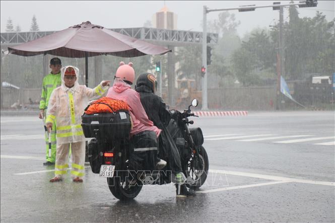
In response to this risk, road and bridge management forces are required to regularly inspect the site, record fluctuations in water levels and erosion at the base of bridge abutments and piers, and continuously report to the road management areas and the Vietnam Road Administration for timely guidance. Monitoring is carried out day and night, with the coordination of traffic police, traffic inspectors, militia, and local authorities.
Currently, traffic management plans are being implemented comprehensively, with close coordination between forces from the Ministry of Construction , the Vietnam Road Administration, and local authorities.
Mr. Nguyen Thanh Binh, Director of Road Management Area III, said: “As soon as the floodwaters rose and reached the bottom of the bridge girders, we immediately implemented measures to close the bridge, put up warning signs, reroute traffic, and deploy forces on continuous standby. This is a necessary measure to protect the safety of the structure and ensure that no unfortunate incidents occur to people and vehicles.”
According to the Vietnam Road Administration, after the floodwaters recede, the bridge management unit will conduct a comprehensive inspection of the structural condition, especially the beams, bearings, piers, and foundations, to assess their load-bearing capacity before allowing traffic to resume. The entire process will be carried out according to strict technical procedures, under the supervision of the Vietnam Road Administration and relevant specialized agencies.
Amidst the ongoing and complex flooding situation in the Central region, particularly in Quang Tri, Quang Nam , Quang Ngai provinces, Hue city, and Da Nang city, ensuring traffic safety and the safety of road infrastructure has been identified by the Vietnam Road Administration as a top priority and urgent task. Road management areas are required to maintain a ready force and equipment to respond to the situation, closely monitor weather developments, especially at vulnerable bridge, culvert, and roadbed locations, and areas at risk of deep flooding or landslides.
The Vietnam Road Administration advises road users to strictly follow the instructions of the authorities, not to enter areas where traffic is temporarily suspended, and to monitor warning information from road management agencies and local authorities to proactively choose appropriate and safe routes during these days of complex rain and flooding.
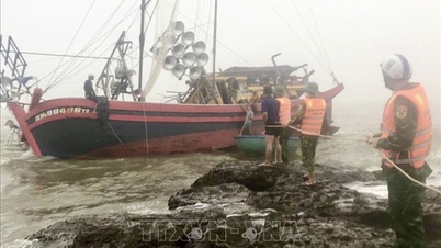
The rapid rise in river water levels, with floodwaters reaching the bottom of the bridge girders, is a warning sign of a high level of danger to the structure. Under the pressure of the strong current, mud, and debris, if vehicles continue to pass, the risk of erosion of the piers, damage to the girders, and complete bridge collapse is entirely possible.
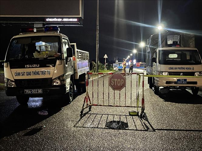
On October 29th, when floodwaters reached the bottom of the Chau O bridge – a structure located at kilometer marker 1036+261 on National Highway 1 in Binh Son commune, Quang Ngai province – the bridge closure order was officially implemented, with checkpoints stationed at both ends of the bridge to control, guide, and warn vehicles from a distance.
Chau O Bridge is one of the important bridges on National Highway 1 through Quang Ngai province, spanning the Tra Bong River and connecting the bustling industrial and residential areas of Binh Son district.
According to the Vietnam Road Administration, in recent years, the bridge has frequently been affected by heavy rains and floods due to the steep terrain and wide river basin. The situation of water rising to the bridge girders like this is very rare, reflecting the severity of the current floods in the Central region.
At this time, barricades have been erected to temporarily prohibit people and vehicles from crossing the Chau O bridge to ensure absolute safety for the structure and the public.
Source: https://baotintuc.vn/kinh-te/cap-bach-ung-pho-voi-nguy-co-mat-an-toan-ket-cau-cau-duong-20251030183848958.htm
![[Photo] Prime Minister Pham Minh Chinh receives the Governor of Tochigi Province (Japan)](/_next/image?url=https%3A%2F%2Fvphoto.vietnam.vn%2Fthumb%2F1200x675%2Fvietnam%2Fresource%2FIMAGE%2F2025%2F12%2F16%2F1765892133176_dsc-8082-6425-jpg.webp&w=3840&q=75)

![[Photo] Prime Minister Pham Minh Chinh receives Lao Minister of Education and Sports Thongsalith Mangnormek](/_next/image?url=https%3A%2F%2Fvphoto.vietnam.vn%2Fthumb%2F1200x675%2Fvietnam%2Fresource%2FIMAGE%2F2025%2F12%2F16%2F1765876834721_dsc-7519-jpg.webp&w=3840&q=75)
![[Image] Leaked images ahead of the 2025 Community Action Awards gala.](/_next/image?url=https%3A%2F%2Fvphoto.vietnam.vn%2Fthumb%2F1200x675%2Fvietnam%2Fresource%2FIMAGE%2F2025%2F12%2F16%2F1765882828720_ndo_br_thiet-ke-chua-co-ten-45-png.webp&w=3840&q=75)

![[Live] 2025 Community Action Awards Gala](/_next/image?url=https%3A%2F%2Fvphoto.vietnam.vn%2Fthumb%2F1200x675%2Fvietnam%2Fresource%2FIMAGE%2F2025%2F12%2F16%2F1765899631650_ndo_tr_z7334013144784-9f9fe10a6d63584c85aff40f2957c250-jpg.webp&w=3840&q=75)


![[Photo] Prime Minister Pham Minh Chinh attends the Vietnam Economic Forum 2025](https://vphoto.vietnam.vn/thumb/402x226/vietnam/resource/IMAGE/2025/12/16/1765893035503_ndo_br_dsc-8043-jpg.webp)


Comment (0)