
Expanding urban areas
After the merger, the average urbanization rate of the new city decreased significantly, but Da Nang's urban space expanded southward and still has great potential for development. Besides the old central urban area, Da Nang now has a continuous strip of land encompassing seven wards formerly belonging to Dien Ban town and Hoi An city.
Following this trend of expansion, the Da Nang urban area will continue upstream towards the Vu Gia River or across the Thu Bon River, with several semi-urban areas transforming into cities. Most notably, the communes of Hoa Tien, Dai Loc, and Thang Binh are all aiming to meet the criteria to become wards by 2030. In reality, many core areas of these communes have long resembled urban areas, having once been bustling towns like Ha Lam and Ai Nghia.
According to the Da Nang Institute for Socio -Economic Development Research, Da Nang - Hoi An - Dien Ban - My Son is not only a modern economic, service, and urbanization center, but also a strategic bridge between the coastal urban chain and the western midland and mountainous region. The entire urban chain needs synchronized digitalization, open data connectivity, and smart infrastructure to form a high-quality service, education, tourism, and finance axis for the Central Vietnam economic growth region.
Waiting for the city streets to be connected.
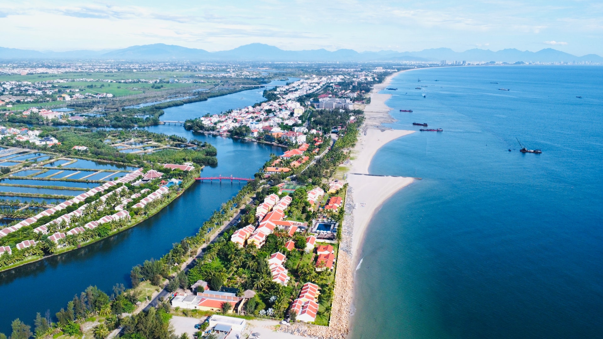
Looking at the entire new urban area of Da Nang, it's easy to see the discontinuity between the central urban strip of Da Nang and the four wards of the former Tam Ky city. There are two main axes connecting this urban strip: along the main highway (National Highway 1) and along the newly formed coastal road.
The outlines of cities are scattered among the towns and townships along the traditional main road, but the strip of sandy coastline in the southeast seems to hold even greater potential to transform into a new urban center.
Just before the merger, the authorities approved the general urban plan for Duy Hai - Duy Nghia (now part of Duy Nghia commune) and the general urban plan for the new Binh Minh urban area (now part of Thang An commune).
According to the Department of Construction, these approved plans will remain in effect. Simultaneously, the implementation of the plans and projects according to the approved plans will continue until a new plan is issued to replace it or until the validity period expires as stipulated in the Law on Urban and Rural Planning.
In fact, Resolution No. 43-NQ/TW of the Politburo on building and developing Da Nang city until 2030, with a vision to 2045 (issued before the reorganization of provincial-level administrative units) emphasized the construction of an urban chain from Lang Co to South Hoi An. This demonstrates the enormous potential of this coastal strip, even though much of the southern part of the strip remains a "low-lying area" of urban development.
According to experts, while major cities in the past developed along rivers, today most megacities around the world are oriented towards the sea.
According to architect Tran Ngoc Chinh, Chairman of the Vietnam Urban Planning and Development Association, a major advantage in Da Nang's urbanization process is that the urban strip along the eastern region not only faces the sea but also "backs onto" two rivers running parallel to the coast: the Co Co and Truong Giang rivers. This is rare in Vietnam, so the local government needs to systematically plan the urban space in conjunction with it, paying particular attention to climate change adaptation.
According to Ms. Tran Thi Thanh Tam, Director of the Da Nang Department of Finance, one of the six driving forces for future growth in Da Nang city is investment in the construction and formation of a chain of coastal urban areas, large-scale, modern, and smart green urban areas in the East region, and urban development on Da Nang Bay and the sea.
Accordingly, from the south of Hai Van Pass to the north of Thu Bon River, priority will be given to developing tourism, commercial services, finance, passenger transport - logistics associated with seaports and international airports, and high-tech industries. Urban infrastructure in the area south of Thu Bon River will be developed towards international-class resort tourism, combined with promoting the exploitation of marine economic development potential. Meanwhile, the Tam Ky - Nui Thanh area will prioritize the development of industry, transport (goods) - logistics associated with seaports and Chu Lai airport.
Source: https://baodanang.vn/cho-noi-lien-dai-pho-3309588.html


Comment (0)