
(Chinhphu.vn) - Storm No. 3 is the strongest storm in the past 30 years in the East Sea region. It is the storm with the fastest increasing intensity, and the rate of deterioration along its path does not follow normal rules.
 - Photo 1.")
Path of storm number 3 ( Yagi )
Storm No. 3 (Yagi) has many unusual features
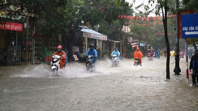
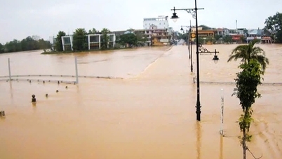
According to the Director of the National Center for Hydro-Meteorological Forecasting, Mai Van Khiem, storm No. 3 is the strongest storm in the past 30 years in the East Sea. This is also a storm with a very fast increase in intensity, in just 24 hours the storm's intensity increased by 8 levels and maintained the super storm level for a long time. When it landed in the East of Hainan Island (China), it still maintained the super storm level. Notably, the level of reduction in the storm's path did not follow the usual rules. The storm caused Hai Phong, Quang Ninh, and Thai Binh cities to warn of level 4 natural disaster risk, which is close to disaster level. Yen Bai and Lao Cai provinces had to warn of level 3 natural disaster risk for flash floods and landslides, which is the highest level. Specifically, normally when passing Hainan Island (China) into the Gulf of Tonkin, storms often weaken quickly, but with storm No. 3, the intensity did not decrease quickly, when approaching the coast of Quang Ninh - Hai Phong, it still maintained the intensity of level 12-13. In addition, the time the storm stayed on land was long (12 hours). Storm No. 3 moved deep into the mainland and weakened into a tropical depression in the Northwest region. However, the heaviest rain due to the circulation of storm No. 3 was mainly in the East of Hoang Lien Son mountain range, although it was not on the path of the storm and was not directly affected by the storm's winds. Most storms with similar trajectories in the past often caused heavy rain in the West of Hoang Lien Son mountain range. Very heavy rain over a large area (including many provinces) in the basins of Thao River, Chay River, Lo River, Gam River with high intensity (over 200 mm/day), lasting for many days after the storm dissipated; In some areas, rainfall of over 200 mm occurred within just 2 hours. "In online discussion sessions between the staff of the National Center for Hydrometeorological Forecasting and international experts from the Regional Typhoon Forecasting Center of Japan and the China Meteorological Agency, they all agreed on the unusual characteristics of storm No. 3 and the heavy rain caused by the storm's circulation in the Gulf of Tonkin, the Northern Midlands and Mountains and the Southern region of China," the Director of the National Center for Hydrometeorological Forecasting shared. - Photo 2.")
Director of the National Center for Hydro-Meteorological Forecasting Mai Van Khiem
Flood peak records
Regarding floods, according to the Director of the National Center for Hydro-Meteorological Forecasting, due to heavy rains, since September 8, water levels on many rivers and streams in the North have risen rapidly. In particular, water levels on Thao River, Lo River, Thuong River, Gam River, Thai Binh River, the lower reaches of the Red River, Luc Nam River, Hoang Long River... have all exceeded alert level 3 (BĐ3), some rivers have exceeded BĐ3 by 3-4m. "In particular, the flood on Thao River in Lao Cai and Yen Bai has exceeded the historical flood peak that existed for 53 years. The flood peak in Yen Bai reached 35.73m at 4:00 p.m. on September 10, 3.73m above BĐ3 and 1.31m above the historical flood level in 1968. The peak water level at Lao Cai station was 86.97m, 3.47m above the alarm level (BĐ3); at Bao Ha it was 61.95m, 4.95m above BĐ3, 1.02m above the historical flood level in 2008 (60.93m); in Yen Bai it peaked at 35.73m, 3.73m above BĐ3, 1.31m above the historical flood level in 1968," Mr. Mai Van Khiem informed. In Hanoi, the water level of the Red River also recorded its highest level in 20 years. Rivers in the Red and Thai Binh river basins - the largest river system in the North - have experienced floods and inundation on a large scale with many levels exceeding the threshold, which is also rare. According to statistics, 20/25 provinces and cities in the North have experienced serious flooding. Regarding flash floods and landslides: due to heavy rain, landslides and flash floods have occurred in many localities, causing very heavy damage to people and property. Some areas have experienced serious flash floods and landslides, such as in the provinces of Cao Bang, Hoa Binh, Lao Cai, Yen Bai, Quang Ninh... In particular, in Lang Nu village, Phuc Khanh commune, Bao Yen district, Lao Cai province, landslides have caused particularly serious damage to people. The main reason is that the mountainous areas in the North have had a lot of rain in the past 3 months, 40-60% higher than the average of many years. In Lao Cai in August, there were 23/31 rainy days and in Yen Bai 21/31 days, which is also rare. In most areas, the soil is saturated with water, so when there is a very heavy rain, lasting for many days with high intensity like recently, landslides have occurred in many places. Lao Cai experienced flash floods, large-scale landslides, Yen Bai had smaller landslides but occurred in many places (in Yen Bai city alone, over 1,000 landslides have been recorded). The East Sea will have 1-2 storms, warning of heavy rain and floods in the Central region. Regarding the weather forecast for the coming time, the National Center for Hydro-Meteorological Forecasting said that storm Bebinca is active in the Northwest Pacific , making landfall in the eastern region of China, not affecting Vietnam. In the East Sea, there is a tropical convergence zone (low pressure trough) combined with strong southwest monsoon winds that will cause rain in the Central Highlands and the South until the end of September 16, with average rainfall of 40-80mm, concentrated in the afternoon and at night. This type of rain does not have a major impact on the North. The weather forecast for the North in the next 7 days is mainly little rain, with intermittent sunny days. From now until the end of September 17, the North, focusing on the provinces of Lao Cai, Yen Bai, Phu Tho, Quang Ninh and Hai Phong, will have moderate rain, with average rainfall of 10-30mm/day, and locally heavy rain of over 50mm/day. From now until the end of September, there is a possibility of 1-2 storms appearing in the East Sea (likely concentrated in the last 10 days of September) and may affect the North and North Central regions. Warning of high risk of heavy rain and floods in the Central region during the flood season of October-November 2024.Chinhphu.vn
Source: https://baochinhphu.vn/chuyen-gia-tong-ket-nhung-diem-bat-thuong-cua-bao-so-3-yagi-102240916154239675.htm
![[Photo] General Secretary To Lam and National Assembly Chairman Tran Thanh Man attend the 80th Anniversary of the Traditional Day of the Vietnamese Inspection Sector](https://vphoto.vietnam.vn/thumb/1200x675/vietnam/resource/IMAGE/2025/11/17/1763356362984_a2-bnd-7940-3561-jpg.webp)


Comment (0)