
According to the National Center for Hydro-Meteorological Forecasting, at 1:00 p.m. on October 21, the center of the storm was located at about 17.5 degrees North latitude; 112.2 degrees East longitude, in the sea north of Hoang Sa special zone, about 450km East Northeast of Da Nang City. The strongest wind near the center of the storm was level 9-10 (75-102 km/h), gusting to level 12. Moving southwest at a speed of 10-15km/h.
Forecast by 13:00 on October 22, the storm is about 145 km east-northeast of Da Nang city, with strong winds of level 8, gusts of level 10, moving in the West-Southwest direction at a speed of about 10-15 km/h and gradually weakening. The affected area is the sea area west of the North East Sea (including Hoang Sa special zone), the sea area from South Quang Tri to Quang Ngai . Natural disaster risk level 3.
Then, at 1:00 p.m. on October 23, the storm in the Southern Laos area, wind speed below level 6, gusts, moving in the West Southwest direction at a speed of about 10-15 km/h and is likely to gradually weaken into a tropical depression and then a low pressure area. The affected area is the sea area from the South of Quang Tri to Quang Ngai (including the special zones of Con Co, Ly Son and Cu Lao Cham island), the mainland coastal provinces and cities from Quang Tri to Da Nang.
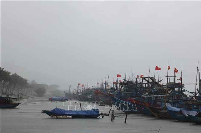
Due to the impact of the storm, the western sea area of the North East Sea (including Hoang Sa special zone) has strong winds of level 7-8; the area near the storm's eye has strong winds of level 9-10, gusting to level 12; waves 3-5m high, the area near the storm's eye has waves of 5-7m high, very rough seas.
The sea area from Quang Tri to Quang Ngai (including Con Co special zone, Cu Lao Cham island and Ly Son special zone) has strong winds of level 6, increasing to level 7 from the morning of October 22, the area near the storm center has level 8, gusts of level 10, waves 3-5m high, rough seas.
All ships and boats operating in the above mentioned dangerous areas are susceptible to the impact of storms, whirlwinds, strong winds and large waves.
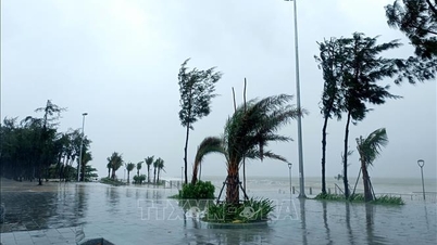
On land: Due to the influence of storm circulation No. 12 combined with strong cold air, from the afternoon of October 22, on the mainland coastal provinces and cities from Quang Tri to Da Nang, winds will gradually increase to level 6, sometimes level 7, gusting to level 8-9. Along with that, storm circulation and cold air combined with East wind disturbances, terrain effects, so from noon on October 22 to October 27, the area from Ha Tinh to Quang Ngai is likely to have widespread heavy rain (heavy rain concentrated from the afternoon of October 22 to the end of October 23). Total rainfall in: Ha Tinh to North Quang Tri and Quang Ngai is about 200-400mm, locally over 500mm; the area from South Quang Tri to Da Nang city is commonly 500-700mm, locally over 900mm. Warning of heavy rain over 200mm/3 hours.
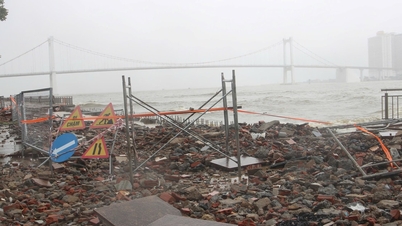
Heavy rains in the Central region are likely to last until the end of October 2025. There is a high risk of flash floods and landslides in mountainous areas, and flooding in low-lying and urban areas.
"Localities need to pay attention to safely operating hydroelectric and irrigation reservoirs before, during and after the storm, and prepare response plans for flood scenarios on rivers from Quang Tri to Quang Ngai that may reach alert level 3 and exceed alert level 3. Beware of the risk of thunderstorms, tornadoes with strong gusts of wind in the storm circulation area, both before and during the storm's landfall. Forecast level of natural disaster risk due to floods and inundation: level 3", Associate Professor, Doctor, Director of the National Center for Hydro-Meteorological Forecasting Mai Van Khiem noted.
Source: https://baotintuc.vn/van-de-quan-tam/de-phong-nuoc-dang-o-vung-ven-bo-ven-bien-tu-quang-tri-toi-da-nang-20251021154621936.htm


![[Photo] Nhan Dan Newspaper displays and solicits comments on the Draft Documents of the 14th National Party Congress](https://vphoto.vietnam.vn/thumb/1200x675/vietnam/resource/IMAGE/2025/10/26/1761470328996_ndo_br_bao-long-171-8916-jpg.webp)


![[Photo] Enjoy the Liuyang Fireworks Festival in Hunan, China](https://vphoto.vietnam.vn/thumb/1200x675/vietnam/resource/IMAGE/2025/10/26/1761463428882_ndo_br_02-1-my-1-jpg.webp)


Comment (0)