Among them, An Khe Pass is a scenic spot with profound historical significance, connecting the two regions of Binh Dinh and Gia Lai .
The Bahnar Ala Kông people call An Khê Pass Mang Pass, meaning "the gate" to cross from the coastal plains to the mountainous region, the land of the inhabitants of the Northern Central Highlands. To the west, crossing the An Khê plateau, there is another higher pass called Mang Yang (Heaven's Gate) leading to the Pleiku plateau and to the border region bordering the land of temples (Cambodia).
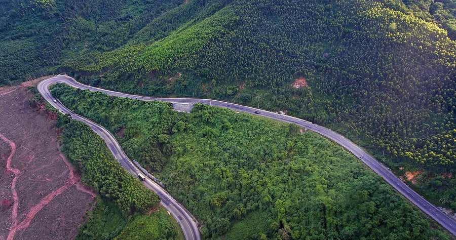
An Khe Pass. Photo: Phan Nguyen
Geographically, the towering mountain ranges of the eastern Truong Son Mountains, running in a north-south direction, divided this land into two regions: the highlands and the lowlands. In the past, the inhabitants of Quy Ninh (the plains of present-day Binh Dinh province) traded with the mountain dwellers via two routes: land (crossing the An Khe pass) and river (upstream of the Con River). From this, the people of Binh Dinh have a saying: "Tell those in the highlands to send bamboo shoots down and flying fish up." In Le Quy Don's "Phu Bien Tap Luc," "nguon" refers to a geographical location in the upper reaches of the river, equivalent to a district in the lowlands.
Evaluating the products brought from the upstream areas to the Quy Nhon plain in those days, in "Historical Records of Dynastic Constitutions," Phan Huy Chu noted: "There were many products such as agarwood, incense, rhinoceros horns, elephant tusks, gold, silver, beeswax, and various kinds of good quality wood." This proves that, from the feudal era, the trade and transportation of goods and precious products from the mountains and forests to the plains of what is now Binh Dinh province were carried out by merchant ships and distributed throughout the country and abroad.
Before the An Khe pass road was built as part of the project to expand National Highway 19 into the Central Highlands, it was just a narrow, small trail, and few people dared to venture over its long, winding slopes, jagged rocks, dense vegetation, and numerous wild animals.
In his book "The Landscape of Binh Dinh," Quach Tan mentions a trail at An Khe Pass, then called Vinh Vien Pass, with an altitude of about 740 meters and a length of 10 kilometers, which was very difficult to traverse. Besides the Chang Hang slope, the landmarks often mentioned when climbing the pass include the bends of the starfruit tree, the bends of the ancient fig tree, and the ancient banyan tree where travelers often rested.
Therefore, in those days, for trade, carrying goods, merchants from the lowlands and residents from the highlands often traveled through the Van Tue Pass, in the Vinh Thanh and Cuu An areas, about 10 km north of the present-day An Khe Pass, where Ong Binh Island is located; to the west of Thuong Giang village is the Dong Hao Pass road on the eastern route to Tram Go, located northwest of An Son, where military supplies were hidden during the Tay Son dynasty.
In the mid-17th century, the Nguyen lords in Dang Trong (Southern Vietnam) brought the first Kinh people across the mountain pass to establish Tay Son village (at that time belonging to Tuy Vien district, Quy Ninh prefecture (which was renamed Quy Nhon prefecture in 1742). "Tay Son village had two hamlets, Nhat and Nhi, now the two villages of An Khe and Cuu An, in Quy Ninh land, now Hoai Nhon" (Dai Nam Chinh Bien Liet Truyen).
During the time of the Tay Son Three Heroes, who gathered their righteous cause in An Khe as their main base, they won over the hearts of the local people, prepared food and weapons, and trained troops in preparation for the campaign against the North. Travel between the Lower and Upper Tay Son regions became more frequent and intense. Along the mountain passes from Van Tue to Vinh Vien Pass (An Khe), Ong Binh Hill, Ong Nhac Hill, etc., were secret areas with military outposts, supply depots, and the Xom Ke base, all meticulously guarded to avoid enemy detection. It was precisely these steep mountain ranges and high passes blocking the access routes that provided such strong protection to the base area.
Today, a legend is still told about Nguyen Hue receiving the O Long sword from a pair of black cobras in the middle of the An Khe pass, while he was leading his troops across the pass to the lower region. The story reflects the people's unwavering support for the Tay Son rebellion and their belief that the spiritual energy still thrives in the mountains bordering the An Khe-Binh Dinh region today.

An Khe Pass. Photo: Phan Nguyen
During the Nguyen dynasty, recognizing the economic and military potential of the An Khe plateau, officials were sent to recruit people from the coastal areas to cross the high mountain pass to An Son to clear land and establish villages for settlement.
According to Andrew Hardy's "History of the Reclamation of the An Khe Plateau," between 1864 and 1888, the Hue court launched three waves of migration to An Son to reclaim land, expand territory, and assert control over a part of the western mountainous region of Binh Dinh. However, at that time, the An Khe pass had not yet been opened up and remained an obstacle hindering travel and trade between the lowlands and the highlands.
By the late 19th and early 20th centuries, the French colonialists plotted to permanently occupy the Central Highlands to exploit its resources for the benefit of their motherland. They began building roads from the central coast to the Central Highlands, including National Highway 19. From there, the road through the An Khe pass was formed, opening the gateway to the upstream border region.
During the war against the French, An Khe Pass became a gateway for the enemy to attack the Binh Dinh plains from the highlands. Fierce battles between our army and French troops frequently occurred in this area. History also records the heroic bombing by Ngo May near the Voi stream close to An Khe Pass, which annihilated a French army unit advancing into the plains, creating a great sensation and striking fear into the hearts of the French colonialists.
In the early days of the resistance against the French, the army and people of Gia Lai, having evacuated from Binh Dinh province, crossed the An Khe pass to establish a base in Xom Ke, gradually advancing to attack the enemy and liberate their beloved Gia Lai region.
In particular, during the war against the US, in April 1972, our army achieved a remarkable feat at Hill 638, also known as Hon Bui, in the An Khe pass, where the infamous Tiger Division (South Korea) occupied territory. This resounding battle by a unit of the 3rd Golden Star Division caused a shock and left an indelible mark on the South Korean mercenaries and the American expeditionary forces.
Today, the stone monument of the Tiger Division remains intact at the top of An Khe Pass. According to Master Nguyen Quang Tue, who once took Professor Ju Hung Shim (Incheon National University, South Korea) to visit the former battlefield and this historical monument, "...Most of the articles, research works, journalistic pieces, and literary and artistic works from England, America, or South Korea that we consulted all show that the Battle of An Khe Pass in April 1972 has been a haunting memory for many decades for those involved and their relatives."
Since the reunification of the country (1975), An Khe Pass in particular and National Highway 19 in general have always received attention and investment for upgrading and expansion. In the future, An Khe Pass will no longer be an obstacle to trade but a connecting point between the two regions of the newly established Gia Lai province.
Source: https://baogialai.com.vn/deo-an-khe-dau-an-lich-su-post330329.html


![[Photo] General Secretary and President To Lam presides over a working session with the Central Policy and Strategy Committee on the development of the materials industry.](https://vphoto.vietnam.vn/thumb/1200x675/vietnam/resource/IMAGE/2026/05/21/1779359935432_a3-bnd-3129-1412-jpg.webp)
![[Photo] National Assembly Chairman Tran Thanh Man working with the Standing Committee of the Law and Justice Committee](https://vphoto.vietnam.vn/thumb/1200x675/vietnam/resource/IMAGE/2026/05/21/1779378929214_ndo_br_1-4610-jpg.webp)


Comment (0)