
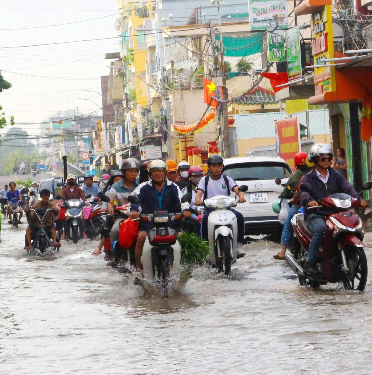
According to the Provincial Hydrometeorological Station, the highest daily peak tide level on river banks and canals in the province rose rapidly and was 2cm lower than alert level 1 (BĐI) to 16cm higher than BĐIII in the past 24 hours.
 |
| Flooding potential from November 14-18 is from 1-50cm |
Forecast: The highest peak tide level at stations from November 14-18 will appear on November 18 (September 29th lunar month). My Thuan station is 18cm higher than BĐIII, Cho Lach and Cau Quan stations are 5cm higher than BĐIII, Tra Vinh station is 20cm higher than BĐIII, the remaining stations are 2cm higher than BĐII to approximately BĐIII.
The peak time at My Thuan and Cho Lach stations is from 1:30 a.m. to 3:00 a.m. on November 18. The peak time at My Hoa, Tra Vinh and Cau Quan stations is from 1:00 a.m. to 2:30 a.m. on November 18. The peak time at An Thuan, Binh Dai and Ben Trai stations is from 0:00 a.m. to 1:30 a.m. on November 18.
The possibility of flooding low-lying areas across the province. Flooding can have a negative impact on the environment, road and waterway traffic activities, residential areas; fruit growing areas, livestock areas, aquaculture areas; especially the upstream areas of the province; the possibility of deep flooding in areas along the Tien River, Ham Luong River, Co Chien River, Mang Thit River, Hau River, areas outside the dike; some roads in Thanh Duc Ward; Phuoc Hau Ward, Long Chau Ward...; National Highway 1, Binh Minh Ward (especially Binh Minh bus station), National Highway 57 section; provincial roads 901, 903, 904, 905, 907, 908, 909, 910, other low-lying areas, weak dike areas - without and outside the dike, areas of sandbanks, islands, riverside areas, and coastal areas.
The possibility of flooding from November 14-18 is from 1-50cm, the deepest flooding depth on November 18 is from 5-50cm, some places are flooded from 45-65cm deep (Binh Minh bus station), the flooding depth will gradually increase according to the rising water level of the tide. Warning information about natural disaster risk level: level 2.
It is recommended that localities need to have plans to protect and reinforce the dike system, raise furniture and belongings, and proactively deal with flooding and landslides caused by high tides combined with upstream floods, rain and other factors.
News and photos: THAO LY
Source: https://baovinhlong.com.vn/thoi-su/202511/du-bao-muc-nuoc-dinh-trieu-cao-nhat-tai-cac-tram-xuat-hien-trong-ngay-1811-8922924/

![[Photo] Prime Minister Pham Minh Chinh meets with representatives of outstanding teachers](https://vphoto.vietnam.vn/thumb/1200x675/vietnam/resource/IMAGE/2025/11/15/1763215934276_dsc-0578-jpg.webp)
![[Photo] Panorama of the 2025 Community Action Awards Final Round](https://vphoto.vietnam.vn/thumb/1200x675/vietnam/resource/IMAGE/2025/11/15/1763206932975_chi-7868-jpg.webp)

![[Photo] General Secretary To Lam receives Vice President of Luxshare-ICT Group (China)](https://vphoto.vietnam.vn/thumb/1200x675/vietnam/resource/IMAGE/2025/11/15/1763211137119_a1-bnd-7809-8939-jpg.webp)


Comment (0)