
These are the most powerful hurricanes on the planet, carrying winds capable of causing widespread destruction.
“Giant machine” brings ocean energy to the sky
According to NASA Space Place, tropical cyclones act like giant machines that get fuel from warm, moist air over the ocean.
As the air rises, leaving a low pressure area below, colder air from the surroundings immediately rushes in, is warmed, and continues to rise.
This process repeats itself, causing the cloud and wind system to expand and thrive thanks to being continuously “nourished” by heat and water vapor from the ocean.
What is special is that the vortex motion of a hurricane is directly affected by the Coriolis effect, a consequence of the Earth's rotation around its axis.

The Coriolis effect causes hurricanes to rotate in different directions in the two hemispheres.
In the Northern Hemisphere, hurricanes rotate counterclockwise, while in the Southern Hemisphere, they rotate clockwise.
This force causes the air masses to move in the wrong direction and swirl around the low pressure area, instead of rushing straight into the center.
Viewed from space, a complete hurricane appears as a giant circular disk with spiraling cloud bands rotating around the eye.
The peaceful "eye" in the midst of the storm
In contrast to the destructive power outside, the eye of the storm is the calmest place in the entire system.
This is an area of little cloud, light wind, low pressure, with an average diameter of 30–60km.
However, there are storms with an eye of only about 3km (hurricane Wilma), and there are storms with a diameter of up to 320km (hurricane Carmen in 1960 - according to radar data from Okinawa, Japan).
Surrounding the eye of the storm is a ring of dense clouds called the eyewall, where the strongest winds, heaviest rains and most dangerous areas are concentrated.

Image of a storm eye taken from the space station (Photo: NASA).
As warm, moist air continuously rises from the ocean surface, it curls in and moves in a spiral orbit around the eye of the storm, creating “walls” of clouds up to tens of kilometers high.
High-pressure air from the upper atmosphere moves down into the eye of the storm, causing this region to become stable and maintain its characteristic shape throughout the life of the storm.
When does a hurricane form?
Climate change causes storms to appear more and more frequently with strong intensity and unpredictable developments.
Faced with that situation, the National Center for Hydro-Meteorological Forecasting issued instructions on recognizing and distinguishing storm wind levels, as well as the impact of each level.
The storm has the strongest winds from level 8 or higher and may be accompanied by gusts.
Storms with the strongest winds from level 10-11 are called strong storms, from level 12-15 are very strong storms, and from level 16 and above are classified as super storms.
In the initial stage, disturbances on the sea surface create a tropical depression, with average wind speeds of 39-61 km/h.
At this level, trees begin to shake, pedestrians have difficulty moving, seas are rough and pose a danger to small boats.
When wind speeds exceed 61 km/h, a tropical depression develops into a storm.
Winds can break tree branches and rip off roofs of weak structures, making it nearly impossible for pedestrians to walk against the wind. Seas can be very rough, posing a great danger to ships operating near shore.
When winds exceed 118 km/h, the storm is classified as a very strong storm (level 12 to 15).
At this level, the destruction is extremely great, small boats can easily be broken or sunk if not safely anchored.
With a level 16-17 super typhoon, wind speeds can exceed 184 km/h, the level of destruction is considered the greatest.
High waves and strong winds can sink even large ships, causing serious damage to people and property if they make landfall.
The direction of a storm's movement is usually determined by 16 main directions (North, Northeast, East, Southeast, South, Southwest, West, Northwest...).
Why do storms weaken when they make landfall?
Hurricanes survive only by being fed by the constant flow of warm ocean water. When they move over land or into cold waters, this energy is cut off, causing the storm to rapidly weaken.
Friction with the ground surface also reduces wind speed and breaks up the vortex structure.
However, before dissipating, the storm can still cause heavy rain, flash floods and landslides due to the huge amount of water vapor it carries.
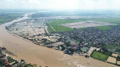
Some storms, though weakened, continued to move inland, causing widespread flooding and severe damage.

Bac Ninh experienced historic flooding due to the impact of storm Matmo (Photo: Manh Quan).
According to the World Meteorological Organization (WMO), climate change is causing ocean temperatures to rise, creating favorable conditions for the formation of more powerful, longer-lasting and more widespread storms.
Understanding the mechanism of storm formation and evolution helps people improve their ability to forecast early, minimizing damage to people and property.
Today's modern forecast models combine data from satellites, weather radars and artificial intelligence to predict the path, intensity and speed of storm development with increasing accuracy.
Source: https://dantri.com.vn/khoa-hoc/giai-ma-qua-trinh-hinh-thanh-cua-nhung-con-bao-20251108111343257.htm

![[Photo] Prime Minister Pham Minh Chinh attends the Patriotic Emulation Congress of the Ministry of Foreign Affairs for the 2025-2030 period](https://vphoto.vietnam.vn/thumb/1200x675/vietnam/resource/IMAGE/2025/11/10/1762762603245_dsc-1428-jpg.webp)

![[Photo] Prime Minister Pham Minh Chinh attends the annual Vietnam Business Forum](https://vphoto.vietnam.vn/thumb/1200x675/vietnam/resource/IMAGE/2025/11/10/1762780307172_dsc-1710-jpg.webp)


![Dong Nai OCOP transition: [Article 3] Linking tourism with OCOP product consumption](https://vphoto.vietnam.vn/thumb/402x226/vietnam/resource/IMAGE/2025/11/10/1762739199309_1324-2740-7_n-162543_981.jpeg)


Comment (0)