
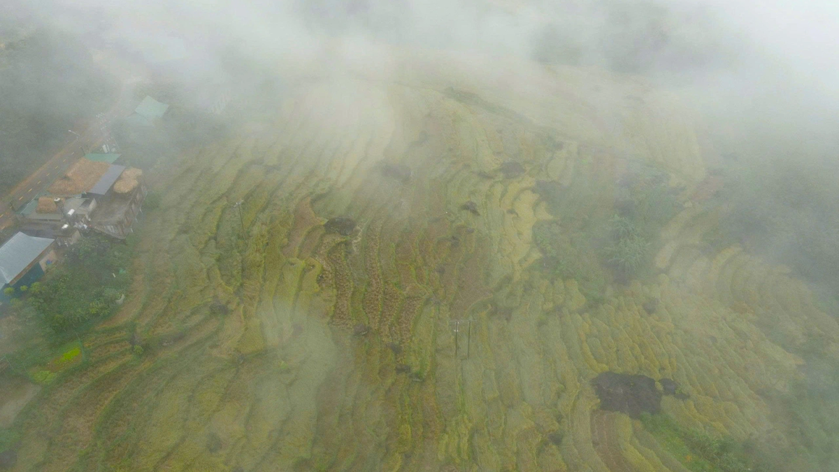
Heavy rain lasting from the night of November 16 to the morning of November 17 in many areas in Dak Lak province caused river and stream water levels to rise, flooding many areas and causing landslides, cutting off traffic.
According to the National Center for Hydro-Meteorological Forecasting, Dak Lak is one of the localities with heavy rainfall, many areas recorded total rainfall of more than 340mm.
Heavy rain from the morning of November 16 to noon of November 17 caused the Krong Bong River to flood many sections of Provincial Road 12 through Krong Bong and Yang Mao communes; National Highway 29 through Tam Giang and Song Hinh communes was also flooded , affecting the travel of vehicles on these routes.

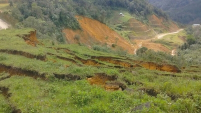
In Giang Mao commune, according to the Chairman of the Commune People's Committee Vo Tan Truc, due to prolonged heavy rains, the water level of rivers and streams rose, causing a household to be deeply flooded and had to be evacuated on November 17. Notably, in Tong Rang A village, a landslide occurred on a hill, causing a house to collapse, but fortunately, people were able to escape in time, so there were no casualties.
In Ton Rang B village and Giang Hanh hamlet, nearly ten households were deeply flooded and urgently evacuated on the evening of November 16.
Currently, the authorities of Yang Mao commune are reviewing and continuing to evacuate households in areas at risk of landslides to safe places. At the same time, they are assigning forces to be on duty in flooded areas and asking people not to return to landslide areas because it is very dangerous.

In Krong Bong commune, Chairman of the Commune People's Committee Nguyen Ngoc Phap said that there was a landslide in village 23 after heavy rain. The commune has put up warning ropes, prohibited people from going to dangerous areas and made plans to evacuate more than 20 households from high-risk areas. The locality has prepared food and necessities to support households at risk of isolation.

According to the Traffic Police Department, Dak Lak Provincial Police, due to heavy rain, many areas on National Highway 29 through Duc Binh and Song Hinh communes were deeply flooded. This is a vital traffic route connecting the eastern and western regions of Dak Lak province, so traffic congestion occurred on the morning of November 17. The Traffic Police Department has deployed forces to warn both ends not to allow vehicles and people to pass through flooded areas to ensure safety. At the same time, a working group was sent to guide vehicles traveling from Buon Ma Thuot ward to Tuy Hoa ward to move along the route National Highway 29 - National Highway 19C - National Highway 25...
On the morning of November 17, Vice Chairman of the Dak Lak Provincial People's Committee Nguyen Thien Van directly inspected the deep flooded areas and requested the owners of lakes and dams in the area to strictly control the operating process to avoid flood on flood, ensuring absolute safety of lakes and dams .

According to the Dak Lak Hydrometeorological Station, rainfall from 7pm on November 16 to 6am on November 17 was generally between 30mm and 100mm, with many places exceeding 200mm. In the next 6 hours, heavy rain will continue with rainfall from 30mm to 70mm, with some places exceeding 100mm.
Forecast for the next 6-12 hours warns of a very high risk of flash floods and landslides in steep terrain; flooding in low-lying areas, residential areas and many traffic routes in the area.
In particular, some inter-commune and inter-village traffic routes may be cut off, especially in the communes: Cu Pui, Yang Mao, Dang Kang, Lien Son Lak, Dak Lieng, Hoa Son, Krong Bong, Dak Phoi, Song Hinh, Ea Ba, Ea Kly, Dray Bhang, Krong Ana, Dur Kmal...
Therefore, authorities recommend that people should be careful when traveling, limit going through underground spillways, riverside areas, streams and mountainous areas to ensure safety...
Source: https://baolamdong.vn/mua-lon-gay-ngap-lut-mot-so-khu-vuc-tren-dia-ban-tinh-dak-lak-403358.html


![[Photo] General Secretary To Lam and National Assembly Chairman Tran Thanh Man attend the 80th Anniversary of the Traditional Day of the Vietnamese Inspection Sector](https://vphoto.vietnam.vn/thumb/1200x675/vietnam/resource/IMAGE/2025/11/17/1763356362984_a2-bnd-7940-3561-jpg.webp)


![[Photo] Lam Dong: Urgently declare emergency situation...](https://vphoto.vietnam.vn/thumb/402x226/vietnam/resource/IMAGE/2025/11/17/1763373171762_cdn-nhandan-vn-images-22f099ca8bc7ae81aa2a8d3416a84bf86af888fb71358dd0bda5d8598bbd8fa94443612225ad0e15b65fbbfd6ecc79d791d561cfe84da2cd9c765694c25efc35-_ndo_br_4.jpeg)


Comment (0)