

Quang Ninh sea area before the storm. (Illustration photo: Mai Mai/Vietnam+)
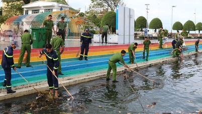
Due to the complicated developments of storm Kajiki (storm No. 5), many localities that are beach tourism destinations from North to South have simultaneously issued orders to ban going to the sea, stopping transportation and tourism activities to ensure safety.
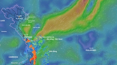
Storm No. 5 is forecast to strengthen to level 13-14, some forecasting agencies predict it may reach level 15. Around noon and afternoon today, August 25, the storm center is likely to make landfall in the provinces from Thanh Hoa to northern Quang Tri .
In Hai Phong, the Hai Phong Civil Defense Command announced the suspension of tourism activities, the Dong Bai-Cai Vieng ferry route and the Cat Hai-Phu Long cable car route have both been temporarily suspended. The management agency requested travel and accommodation units to closely monitor the storm's developments to proactively adjust schedules for tourists.
Quang Ninh has also stopped all sightseeing and accommodation activities at sea, temporarily stopped issuing licenses for watercraft to go out to sea, and required boats to return to shelters from yesterday afternoon, August 24.
The ban on all sea-related activities was applied earlier from Thanh Hoa to Quang Binh (although not in the storm's eye, the sea ban still applies) and Nghe An. Nghe An province also directed businesses to come up with response plans, especially not to stack cargo containers more than two floors to prevent risks from strong winds.

To "avoid" the storm, the passenger transport routes Sa Ky-Ly Son and the internal route between Big Island and Small Island of Ly Son island district, Quang Ngai have temporarily suspended operations.
Chairman of the People's Committee of Ly Son Special Economic Zone, Mr. Nguyen Van Huy, said that although the weather on the island has not yet had heavy rain or strong winds, the government is still ready with forces, vehicles and necessities in case the island is isolated.
In the southern sea area, in Phu Quoc, An Giang, around An Thoi archipelago, there are strong winds and big waves, many canoe tour operators have announced to stop receiving guests to ensure safety.
According to the National Center for Hydro-Meteorological Forecasting, due to the impact of storm No. 5, strong winds were recorded at many stations such as: Bach Long Vi level 7, gust 9; Co To level 6, gust 9; Bai Chay level 6, gust 8; Hon Ngu level 7, gust 8; Con Co level 6, gust 8.
At 6:00 a.m. on August 25, the center of the storm was at about 18.3 degrees North latitude; 107.4 degrees East longitude, about 185 km East Southeast of Nghe An, about 165 km East of Ha Tinh, about 160 km East Northeast of North Quang Tri. Strongest wind: level 14 (150-166 km/h), gusting to level 17. The storm is moving West Northwest at a speed of about 20 km/h.
During the day and night of August 25, the weather in many areas across the country continued to have complicated developments with heavy rain, strong thunderstorms and gusts of wind in many places./.
Source: https://baoangiang.com.vn/nhieu-dia-phuong-tam-dung-du-lich-bien-ne-con-bao-so-5-a427100.html
![[Photo] Prime Minister Pham Minh Chinh and United Nations Secretary-General Antonio Guterres attend the Press Conference of the Hanoi Convention Signing Ceremony](https://vphoto.vietnam.vn/thumb/1200x675/vietnam/resource/IMAGE/2025/10/25/1761391413866_conguoctt-jpg.webp)

![[Photo] National Assembly Chairman Tran Thanh Man receives United Nations Secretary-General Antonio Guterres](https://vphoto.vietnam.vn/thumb/1200x675/vietnam/resource/IMAGE/2025/10/25/1761390815792_ctqh-jpg.webp)


![[Photo] Prime Minister Pham Minh Chinh receives United Nations Secretary-General Antonio Guterres](https://vphoto.vietnam.vn/thumb/1200x675/vietnam/resource/IMAGE/2025/10/25/1761390212729_dsc-1484-jpg.webp)


![[Photo] General Secretary To Lam meets with General Secretary and President of Laos Thongloun Sisoulith](https://vphoto.vietnam.vn/thumb/1200x675/vietnam/resource/IMAGE/2025/10/25/1761380913135_a1-bnd-4751-1374-7632-jpg.webp)


Comment (0)