

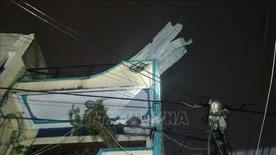
Prolonged heavy rain has caused many new landslides on Truong Son Dong road and Ho Chi Minh road (connecting Da Nang city and Quang Ngai province) - Photo: Vietnam Road Administration
Accordingly, on the Ho Chi Minh road through Lo Xo pass, all landslide points have been opened to one lane of traffic. However, the weather is still raining, the risk of landslides is very high.
Many landslides occurred again, and many new landslides arose.
On the West branch of Ho Chi Minh road, there are still three traffic jams at Km 415+230, Km 415+560 and Km 437+650. It is expected that one lane will be open to traffic at 5:00 p.m. today (November 3).
The Km 437+650 landslide caused a third traffic jam at 9am on November 2nd. Currently, this landslide area is raining heavily and cannot be opened to traffic. Also on this route, 4 new landslides have appeared causing traffic jams at Km 427+500, Km 430+970, Km 431+100, Km 433+620.
The National Highway QLDB III has directed the maintenance unit to mobilize machinery and workers to clean up the road. It is expected that one lane will be open to traffic at 5:00 p.m. on November 3.
This unit added that Truong Son Dong road currently has 14 traffic jams due to landslides.
Of which, there are 10 landslide locations that have not been opened to traffic and 4 new landslide locations at Km 112+890, Km 114+580 - Km 114+780, Km 125+280, Km 126+350 ( Da Nang area).
The Ho Chi Minh Highway section La Son - Hoa Lien (La Son - Hoa Lien Expressway Project) currently has two landslides causing complete traffic jams at Km 41+40 and Km 42+800. In addition, longitudinal cracks have appeared at Km 50+700 - Km 50+800 of this route. This route is currently closed to traffic so that specialized agencies can survey and assess the situation and come up with solutions.

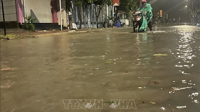
National Highway 1A through Da Nang City has been flooded again - Photo: XD Newspaper

Authorities are on duty 24/7 to guide and assist people traveling through flooded sections on National Highway 1A - Photo: XD Newspaper
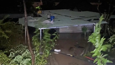
Meanwhile, National Highway 1A through Da Nang City has been flooded again at some locations such as: Km 926+500 - Km 926+930; Km 958+800; Km 957+300 - Km 957+370 (old Ba Ren route) and Km 958+600 - Km 958+670 South of old Ba Ren bridge; Km 984+400 - Km 985+300. Currently, vehicles are moving slowly through flooded sections.
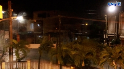
After two days of no rain and floodwaters receding, from the evening of November 2, the water level on the Bo, Huong, Vu Gia - Thu Bon rivers rose again to level three, causing many residential areas in Hue City and Da Nang to be flooded again.
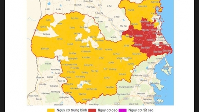
Last night and early morning of November 3, the area from southern Ha Tinh to Da Nang continued to have heavy rain. In 6 hours, the rainfall recorded at Lam Thuy (Quang Tri) was 141 mm, Bach Ma peak (Hue) was 220 mm and Ky Phu (Da Nang) was 301 mm.
Phan Trang
Source: https://baochinhphu.vn/quoc-lo-duong-ho-chi-minh-qua-da-nang-hue-tiep-tuc-sat-lo-nhieu-khu-vuc-ngap-sau-102251103132308938.htm
![[Photo] Closing of the 14th Conference of the 13th Party Central Committee](https://vphoto.vietnam.vn/thumb/1200x675/vietnam/resource/IMAGE/2025/11/06/1762404919012_a1-bnd-5975-5183-jpg.webp)
![[Photo] Prime Minister Pham Minh Chinh receives the delegation of the Semiconductor Manufacturing International (SEMI)](https://vphoto.vietnam.vn/thumb/1200x675/vietnam/resource/IMAGE/2025/11/06/1762434628831_dsc-0219-jpg.webp)


![[Video] The third National Press Award "For the cause of developing Vietnamese culture"](https://vphoto.vietnam.vn/thumb/402x226/vietnam/resource/IMAGE/2025/11/06/1762444834490_giai-bao-chi-vh-3937-jpg.webp)


Comment (0)