
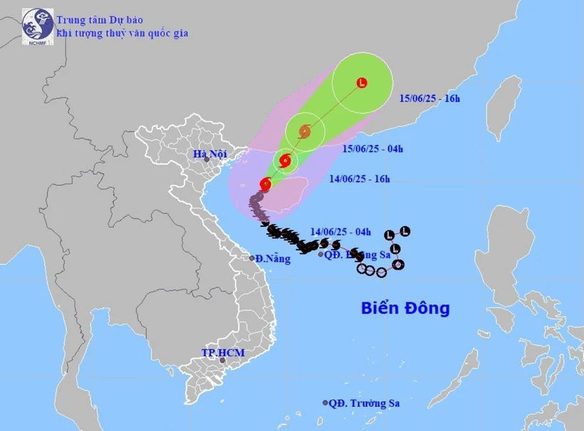
Early morning of June 14, information about the development of storm No. 1, Associate Professor, Doctor, Director of the National Center for Hydro-Meteorological Forecasting Mai Van Khiem said the storm is moving northward in the eastern sea of the Gulf of Tonkin.
Due to the influence of the storm circulation, in Bach Long Vi island district, there are strong winds of level 7, gusting to level 8-9; Con Co island district (Quang Tri) strong winds of level 7, gusting to level 8; Bai Chay and Cua Ong ( Quang Ninh ) strong winds of level 6.
The storm is moving north with winds of level 10-11.
At 4:00 a.m. on June 14, the center of the storm was at about 19.8 degrees North latitude; 108.9 degrees East longitude, in the sea east of the Gulf of Tonkin, about 150km east of Bach Long Vi island.
The strongest wind near the storm center is level 10-11 (89-117 km/h), gusting to level 13; moving north at a speed of 5 km/h.
Commenting specifically on the developments, Director Mai Van Khiem said that as of 4 p.m. on June 14, the storm was moving in a north-northeast direction on the western coastal area of Leizhou Island (China) at a speed of about 10-15 km/h and gradually weakening. The storm's strongest winds were level 9-10, gusting to level 13.
The dangerous area is the sea area of the Gulf of Tonkin and the northwest of the North East Sea. Warning level 3 natural disaster risk.
At 4:00 a.m. on June 15, the storm moved in a north-northeast direction over the northern area of Leizhou Peninsula (China) at a speed of about 15 km/h and gradually weakened.
The storm's strongest wind is level 8-9, gusting to level 12. The dangerous area is the sea area of the Gulf of Tonkin and the northwest of the North East Sea. Disaster risk warning level 3.
At 4:00 p.m. on June 15, the storm moved northeast over the mainland of Guangdong province (China) at a speed of about 20 km/h.
The storm's strongest winds are level 6, gusting to level 8 and gradually weakening into a tropical depression, then weakening into a low pressure area. The dangerous area is the sea area north of the Gulf of Tonkin and northwest of the North East Sea. Disaster risk warning level 3.
Mr. Mai Van Khiem noted that due to the impact of the storm, the sea area of Bac Bo Gulf (including Co To and Bach Long Vi island districts) has strong winds of level 7, the area near the storm's eye has winds of level 8-9, gusts of level 13, waves 2-4m high, especially in the East 4-6m, very rough seas.
Northwest of the North East Sea area has strong winds of level 6, gusts of level 8, waves 2-4m high, rough seas.
Ships operating in the above mentioned dangerous areas are likely to be affected by storms, whirlwinds, strong winds and large waves.
On land, the coastal area of Quang Ninh- Hai Phong has strong winds of level 6, gusting to level 8; the coastal area of Thai Binh-Nam Dinh has strong winds of level 4-5, gusting to level 6-7.
Risk of flash floods and landslides in 6 provinces and cities in the North and Central regions
According to the National Center for Hydro-Meteorological Forecasting, from 3:30 a.m. to 9:30 a.m. on June 14, the provinces from Ha Tinh to Hue city continued to have rain with common accumulated rainfall such as Ha Tinh to Hue city from 10-30mm, some places over 40mm; Lao Cai and Lai Chau from 20-40mm, some places over 60mm.
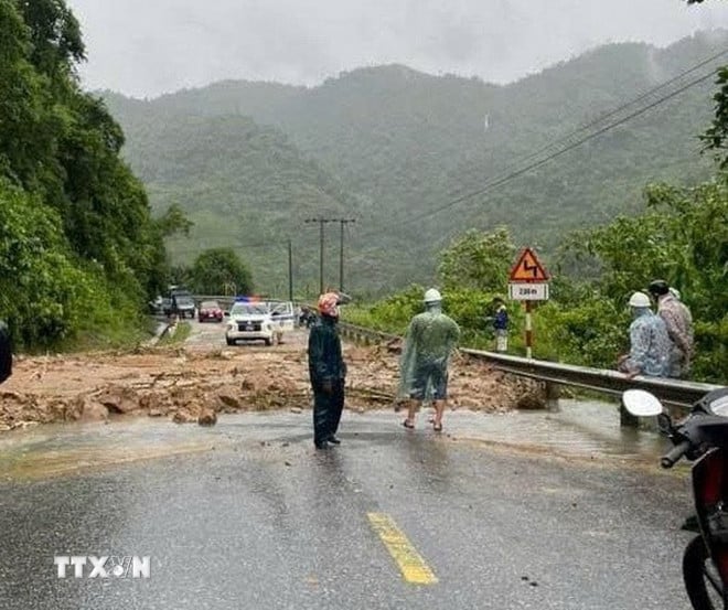
Risk of flash floods on small rivers and streams, landslides on steep slopes in the above provinces and cities, especially in the districts: Muong Te, Nam Nhun, Phong Tho, Sin Ho, Tam Duong, Tan Uyen (Lai Chau province); Bat Xat, Sa Pa town (Lao Cai province); Cam Xuyen, Huong Khe, Ky Anh, Ky Anh town (Ha Tinh province); Bo Trach, Le Thuy, Minh Hoa, Quang Ninh, Quang Trach, Dong Hoi city, Tuyen Hoa, Ba Don town (Quang Binh province); Cam Lo, Dakrong, Gio Linh, Hai Lang, Huong Hoa, Trieu Phong, Quang Tri town, Vinh Linh (Quang Tri province); A Luoi, Phu Xuan, Huong Thuy town, Huong Tra town, Phong Dien town (Hue city).
Warning level of natural disaster risk due to flash floods, landslides, land subsidence due to heavy rain or water flow level 1, Quang Tri level 2.
Flash floods and landslides can have very negative impacts on the environment, threaten people's lives; cause local traffic congestion, affect the movement of vehicles; destroy civil and economic works, causing damage to production and socio-economic activities.
The Hydrometeorological Agency recommends that local authorities pay attention to reviewing bottlenecks and vulnerable locations in the area to take preventive and response measures.
From 2:00 a.m. on June 13 to 2:00 a.m. on June 14, in the provinces and cities from Ha Tinh to Hue, there was moderate to heavy rain, such as: Mac Khe Lake (Ha Tinh) 157mm; Le Thuy (Quang Binh) 247.6mm; Huong Son (Quang Tri) 391.2mm; Hong Van (Hue city) 97.2mm...
From 0-2am on June 14, there was rain in Lao Cai and Lai Chau provinces, some places had moderate rain such as: Nam Ban (Lai Chau) 42.8mm; Ban Khoang (Lao Cai) 26mm...
Soil moisture models show that some areas in the above provinces are close to saturation (over 85%) or have reached saturation.
Weather in regions day and night June 14
Northwest
- There will be showers and thunderstorms in some places, with the possibility of tornadoes, lightning and strong gusts of wind.
Lowest temperature 24-27 degrees Celsius, some places below 23 degrees Celsius. Highest temperature 31-34 degrees Celsius, some places above 34 degrees Celsius.
Northeast
- There will be showers and thunderstorms in some places, with the possibility of tornadoes, lightning and strong gusts of wind. During the day, the wind will be from the North to the Northwest at level 2-3; in coastal areas, it will be level 4-5, gusting to level 6-7, especially in Quang Ninh-Hai Phong, it will be level 6, gusting to level 8; at night, the wind will gradually decrease.
- Lowest temperature 25-28 degrees Celsius, in mountainous areas some places below 24 degrees Celsius. Highest temperature 31-34 degrees Celsius, in some places above 34 degrees Celsius.
Hanoi capital
- There will be showers and thunderstorms in some places, with the possibility of tornadoes, lightning and strong gusts of wind. North to Northwest wind level 2-3.
- Lowest temperature 26-28 degrees Celsius. Highest temperature 32-34 degrees Celsius, some places above 34 degrees Celsius.
Provinces and cities from Thanh Hoa-Hue
- There will be showers and thunderstorms in some places, sunny in the afternoon, with the possibility of tornadoes, lightning and strong gusts of wind during thunderstorms. West to Southwest wind level 2-3, in the northern coastal area on the morning of June 14, level 3-4.
- Lowest temperature 24-27 degrees Celsius. Highest temperature 31-34 degrees Celsius.
Provinces and cities from Da Nang to Binh Thuan
- Sunny day, hot in some places; showers and thunderstorms in the evening and at night, with the possibility of tornadoes, lightning and strong gusts of wind. Southwest wind level 2-3.
- Lowest temperature 25-28 degrees Celsius. Highest temperature 32-35 degrees Celsius, some places above 35 degrees Celsius.
Central Highlands region
- There will be scattered showers and thunderstorms in some places; in the afternoon and evening there will be scattered showers and thunderstorms, with the possibility of tornadoes, lightning and strong gusts of wind. Southwest wind level 2-3.
- Lowest temperature 20-23 degrees Celsius. Highest temperature 28-31 degrees Celsius, some places above 31 degrees Celsius.
Southern Region
- There will be scattered showers and thunderstorms in some places; in the afternoon and evening there will be scattered showers and thunderstorms, with the possibility of tornadoes, lightning and strong gusts of wind. Southwest wind level 2-3.
Lowest temperature 24-27 degrees Celsius. Highest temperature 30-33 degrees Celsius, some places above 33 degrees Celsius.
Source: VNA
Source: https://baophutho.vn/thoi-tiet-ngay-14-6-bao-so-1-di-chuyen-theo-huong-bac-co-kha-nang-suy-yeu-dan-234396.htm


Comment (0)