
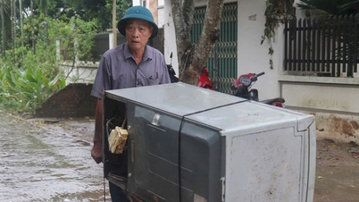
On November 5, the Department of Education and Training of Ho Chi Minh City issued a document requesting the urgent implementation of plans and measures to respond to the impact of storm Kalmaegi at educational institutions in the area.
Faced with the complicated developments of storm Kalmaegi, the Department of Education and Training of Ho Chi Minh City requested leaders of units to focus on implementing measures to prevent and respond to the storm's impacts.
Accordingly, schools must prepare plans to respond to the effects of storms, especially thunderstorms, tornadoes, landslides, and flooding caused by heavy rain combined with high tides.

Educational facilities urgently repair and reinforce structures at risk of being unsafe, coordinate with specialized units to trim trees inside schools, and check drainage systems and power grids to ensure safety.
Units are ready to evacuate students and teachers to safe places, move documents and equipment to dry places before storms and floods. Actively coordinate with local authorities to receive professional support, supplies and equipment when situations arise.
In particular, the Department of Education and Training of Ho Chi Minh City requires heads of educational institutions to closely monitor the developments of storms and floods, maintain regular contact with authorities and local rescue forces to promptly respond in case of incidents. Schools must have plans for online learning and postpone class schedules during days when storms and floods develop complicatedly.
In addition, units proactively coordinate with the local Steering Committee for Natural Disaster Prevention and Search and Rescue to organize propaganda for teachers, students and parents on disaster response skills, first aid and safety in emergency situations. The Department of Education and Training also requires schools to suspend extracurricular educational activities for students before, during and after the storm until safety work returns to normal.
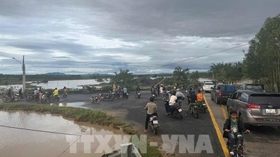
According to the Southern Hydrometeorological Station, due to the influence of the tropical convergence zone and the distant circulation of storm Kalmaegi, Ho Chi Minh City and the Southern region will experience rain for many consecutive days, with some places experiencing moderate to heavy rain, especially from November 6 to 10.
The hydrometeorological agency forecasts that prolonged rain combined with high tides may cause local flooding in some low-lying areas in Ho Chi Minh City, especially wards along the Saigon River, Nha Be area, Binh Thanh, Binh Dong ward, Phu Dinh, etc. People need to closely monitor forecasts of heavy rain and high tides and proactively plan their travel and work.
The National Center for Hydro-Meteorological Forecasting said that on the morning of November 5, storm Kalmaegi entered the eastern part of the central East Sea, becoming the 13th storm in this area in 2025.
Forecast by 7am on November 6, the storm center is about 480km from the coast of Gia Lai province, reaching a maximum speed of 166km/h, reaching level 14, gusting up three levels, maintaining direction but increasing speed to 25km/h. The storm then enters the coastal area of Quang Ngai - Dak Lak with winds of level 13-14 and by 7am on November 7, it is on the mainland of the two above provinces. Wind strength decreases to level 8, gusting to level 10, moving further inland and gradually weakening.
Source: https://tienphong.vn/tphcm-cho-hoc-sinh-o-nha-neu-bao-kalmaegi-phuc-tap-post1793719.tpo
![[Photo] Prime Minister Pham Minh Chinh receives the delegation of the Semiconductor Manufacturing International (SEMI)](https://vphoto.vietnam.vn/thumb/1200x675/vietnam/resource/IMAGE/2025/11/06/1762434628831_dsc-0219-jpg.webp)
![[Photo] Hanoi: Long Bien residents brave the rain to go to work and school amid traffic jams due to bridge closures from early morning](https://vphoto.vietnam.vn/thumb/1200x675/vietnam/resource/IMAGE/2025/11/07/1762485038077_dji-0206-1506-jpg.webp)


Comment (0)