
According to the report of the Department of Dyke Management and Natural Disaster Prevention (Ministry of Agriculture and Environment), by noon on June 11, the Central and Northern Central Highlands regions recorded moderate rain, some places had heavy to very heavy rain, with common amounts of 50-120mm. Some places had extreme rain such as Nhon Hoa (Gia Lai) reaching 204mm, Plei Tho Ga Lake (Gia Lai) 147mm, 3 places in Hue all exceeded 179mm.
It is forecasted that from the afternoon and night of June 11 to June 13, the Central Central region (from Quang Binh to Quang Ngai) will continue to have heavy to very heavy rain, with total rainfall reaching 100-300mm, with some places exceeding 450mm. The Northern Central Highlands is forecast to have rainfall from 70-150mm, with some places exceeding 200mm. The risk of localized rainfall with high intensity of over 200mm in 6 hours, causing flash floods and landslides, is very high. The water levels of rivers are still low, but from the night of June 11 to June 14, there will be a flood on rivers from Quang Binh to Quang Ngai, with the flood peak generally at alert level 1 or higher.
At sea, according to a report from the Border Guard Command, on the morning of June 11, authorities counted and informed 53,792 vessels with a total of 223,054 people about the storm's developments and direction. Of these, 160 vessels with 752 people are operating in the North East Sea, including the Hoang Sa archipelago. The vessels have received warning information and are actively avoiding it.
In the aquaculture sector, the total aquaculture area in coastal provinces from Quang Ninh to Khanh Hoa currently reaches more than 192,000 hectares, including 73,117 hectares of brackish water shrimp farming, 26,047 hectares of tidal mollusk farming and 95,143 hectares of freshwater aquaculture. At the same time, up to 272,367 cages and 3,848 watchtowers are at risk of being affected by storms and floods.

The Department of Dyke Management and Natural Disaster Prevention said that the situation of reservoirs and dykes is also being closely monitored. The South Central and Central Highlands regions have recorded a number of hydroelectric reservoirs discharging water through spillways, including Vinh Son 5 and Dray Hlinh 1 reservoirs. Many irrigation reservoirs in the North Central, South Central and Central Highlands regions are currently at 27-85% of their design capacity, while nearly 90 reservoirs are under construction, posing a potential risk of insecurity if heavy rains continue. Regarding the sea dyke and river dyke systems, from Quang Ninh to Ha Tinh, there are still 20 key weak dyke points and 7 dyke projects under construction, especially in Hai Phong, Thai Binh and Nam Dinh provinces.
The Ministry of Agriculture and Environment assessed that the first storm in the East Sea in 2025 has very complicated developments, long-term impacts and the risk of widespread heavy rain. Ministries, sectors and localities need to continue to seriously implement the Prime Minister's Official Dispatch No. 86/CD-TTg and related instructions to minimize damage.

Updated as of the afternoon of June 11 from the National Center for Hydro-Meteorological Forecasting, the center of storm No. 1 was at about 16.8 degrees North latitude - 112.7 degrees East longitude. The strongest wind near the center of the storm reached level 8 (62-74 km/h), gusting to level 10. The storm moved in a West-Northwest direction at a speed of about 10 km/h (faster than yesterday). It is forecasted that in the next 24 hours, the storm will continue to move in a Northwest direction, then gradually turn North, approaching Hainan Island (China).
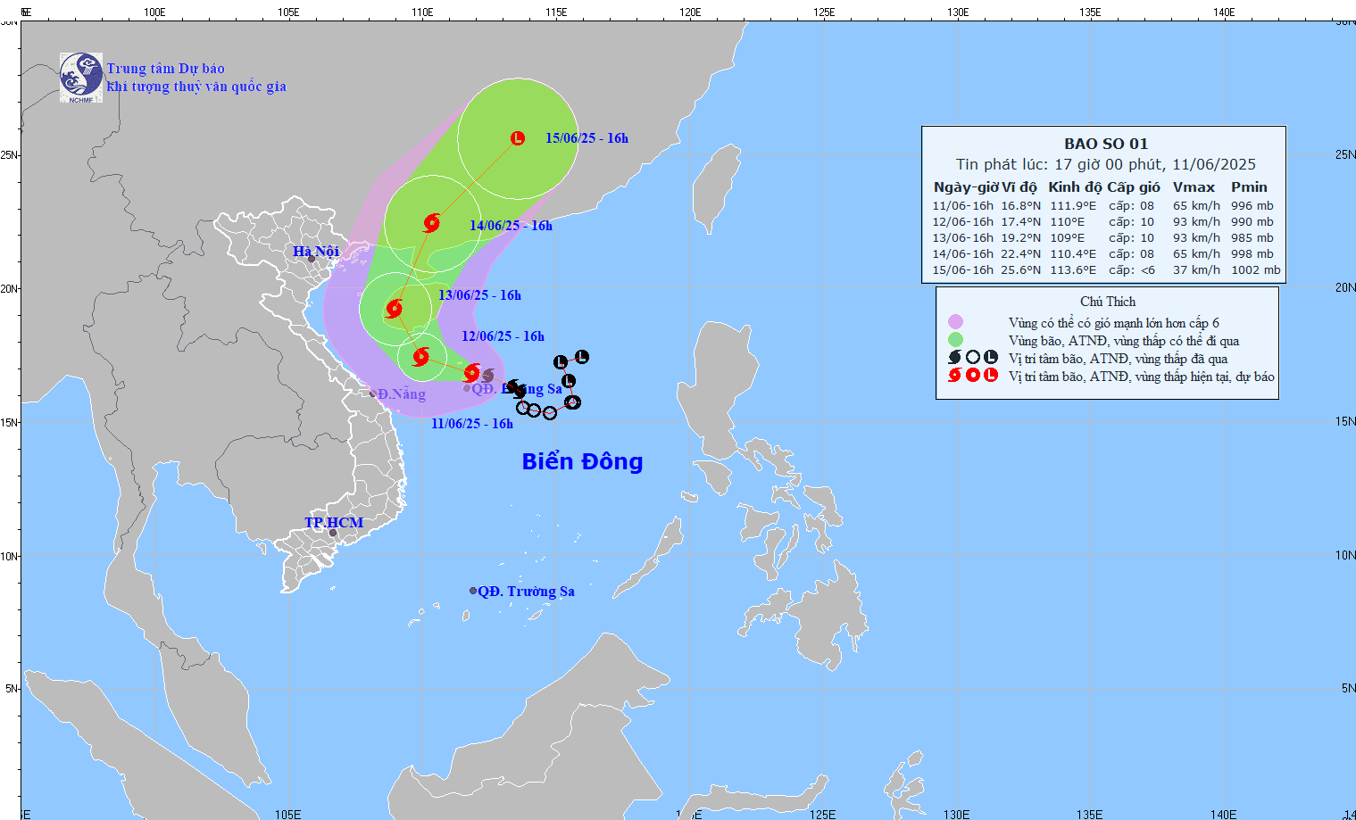
At sea, the danger zone is expanding. In the west of the North East Sea, including the waters of the Hoang Sa archipelago and the north of the central East Sea, there will be thunderstorms, strong winds of level 6-7, near the storm center level 8-9, gusting to level 11. Waves will be 3-5m high. Coastal areas from Quang Ninh to Quang Nam, especially Co To, Hon Ngu, Bach Long Vi, Con Co and the sea area near Hainan Island (China), are forecast to have strong winds of level 6-8, gusting to level 9-11, and rough seas. The sea area from Quang Tri to Quang Ngai is expected to be affected from early tomorrow morning, June 12; and the Gulf of Tonkin from June 13.
On land, with the current storm scenario, the Central region will experience prolonged heavy rain. During the day and night of June 11, the South Central region will experience moderate to heavy rain, with some places experiencing very heavy rain, with the average rainfall ranging from 30-80mm, with the highest rainfall exceeding 150mm. From the night of June 11 to the morning of June 13, the Central Central region (Quang Binh to Quang Ngai) will experience average rainfall of 100-300mm, with some places exceeding 450mm; the North Central Highlands will experience 70-150mm, with the highest rainfall exceeding 200mm.
Source: https://www.sggp.org.vn/ung-pho-con-bao-dau-tien-trong-nam-2025-post799043.html














Comment (0)