
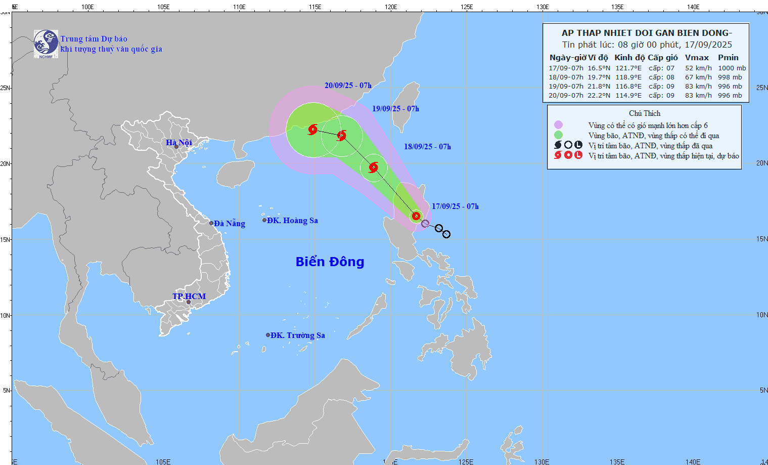
At 7:00 a.m. on September 18, the tropical depression in the northeastern sea of the North East Sea with strong winds of level 8, gusts of level 10; moving northwest at a speed of about 15 - 20 km/h, entering the East Sea and likely to strengthen into a storm. The affected area is the northeastern sea of the North East Sea. Disaster risk level 3.
At 7:00 a.m. on September 19, the tropical depression was in the northeastern sea of the North East Sea, about 300 km east-southeast of Hong Kong (China), with strong winds of level 8-9, gusting to level 11; moving northwest at a speed of about 15 km/h and likely to strengthen. The affected area is the northeastern sea of the North East Sea. Disaster risk level 3.
From the next 48 to 72 hours, the storm will move mainly in the West Northwest direction, about 10 km per hour, with little change in intensity.
Due to the impact of the tropical depression and storm, from the evening of September 17, the northeastern sea area of the North East Sea will have winds gradually increasing to level 6-7, gusting to level 9; near the center of the storm, winds will be level 8, gusting to level 10, with waves 2.5 - 4.5m high. The sea will be rough.
Vessels operating in the above mentioned dangerous areas are susceptible to the impact of storms, whirlwinds, strong winds and large waves.
Source: https://baotintuc.vn/xa-hoi/vung-gan-tam-ap-thap-nhiet-doi-gio-manh-cap-7-giat-cap-9-20250917090927076.htm


![Building a 'fortress' against natural disasters: [Part 2] Changing state from passive to active](https://vphoto.vietnam.vn/thumb/402x226/vietnam/resource/IMAGE/2025/11/06/1762423529917_0242-2223-160125_902.jpeg)


![Dong Nai OCOP transition: [Part 2] Opening new distribution channel](https://vphoto.vietnam.vn/thumb/402x226/vietnam/resource/IMAGE/2025/11/09/1762655780766_4613-anh-1_20240803100041-nongnghiep-154608.jpeg)


Comment (0)