

Continued update...
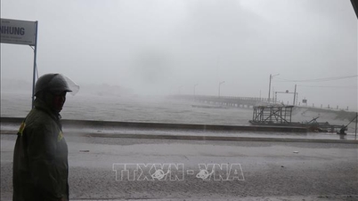
>> On the night of November 6, Deputy Prime Minister Tran Hong Ha inspected the Quy Nhon area the same night after storm No. 13 swept through.
>> On the evening of November 6, Deputy Prime Minister Tran Hong Ha inspected and reviewed response work right before storm No. 13 made landfall.
>> Hue City: Nearly 6,000 officers and soldiers are ready to respond to storm No. 13
>> Storm No. 13 (Kalmaegi) is about to make landfall, Gia Lai will close roads from 5:00 p.m. today
>> 6 airports temporarily closed, many flights canceled before typhoon Kalmaegi makes landfall
>>Deputy Prime Minister Tran Hong Ha held a meeting with the Forward Command Center to deploy emergency response to storm No. 13.
>> URGENT TELEGRAPH: The Prime Minister requests that the evacuation of residents in dangerous areas must be completed before 3:00 p.m. today.
>> Establish a command center to handle the incident of an iron ore ship running aground in Dung Quat waters
>> Viettel activates storm response network No. 13 to ensure information serving rescue command
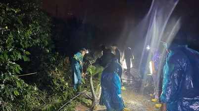
>>Photo series: Armed forces support key areas in responding to storm No. 13
>> Khanh Hoa synchronously deploys measures to protect people from storm No. 13
>> Households in Gia Lai province have been evacuated to safety.
>> Emergency 24/7, ready to admit and treat victims caused by rain and floods
>> Quang Ngai: The entire political system is involved, focusing all its efforts on responding to storm No. 13.
>>Gia Lai and Dak Lak urgently evacuate people to safety
According to the 5am news bulletin this morning, November 7, from the National Center for Hydro-Meteorological Forecasting, early this morning (November 7), the tropical depression (weakened from storm No. 13) has weakened into a low pressure area in the Lower Laos region.
At 4:00 a.m., the low pressure area was located at about 14.6 degrees North latitude; 106.8 degrees East longitude. The strongest wind in the center of the low pressure area was below level 6 (below 39 km/h).
It is forecasted that in the next 12 hours, the low pressure area will continue to move mainly in the West Northwest direction, weakening and gradually dissipating.
Heavy rain forecast for areas from Thanh Hoa to Da Nang and the Central Highlands
Last night and early this morning (November 7), the area from Hue City to Khanh Hoa had heavy to very heavy rain. The rainfall from 7:00 p.m. on November 6 to 0:00 a.m. on November 7 was over 130mm in some places such as: Son Hoi station (Dak Lak) 208mm, Dinh Bach Ma station (Hue City) 204.2mm, Ba Na station (Da Nang City) 141.8mm, Tra Thanh station (Quang Ngai) 138.8mm, Tan An 2 station (Gia Lai) 154.8mm,...
Developments in the next 24–48 hours:
From now until the morning of November 7, the area from South Quang Tri to Da Nang City and the Central Highlands will have moderate rain, heavy rain, and locally very heavy rain with common rainfall of 20-50mm, locally over 80mm.
From November 7 to November 8, the area from Thanh Hoa to Northern Quang Tri will have moderate rain, heavy rain, and locally very heavy rain with common rainfall of 50-150mm, locally over 200mm.
From the night of November 8, heavy rain in the area from Thanh Hoa to Northern Quang Tri tends to decrease.
Current status of tropical depression (2am November 7)
Last night (November 6), after moving deep into the mainland, storm number 13 quickly weakened into a tropical depression.
Due to the influence of the storm after weakening into a tropical depression, at Ly Son station (Quang Ngai) there were strong winds of level 8, gusts of level 10; in the area from Da Nang city to Dak Lak there were strong winds of level 7-9, near the storm center of level 10-11, gusts of level 14.
The area from Hue City to Khanh Hoa had heavy to very heavy rain; the rainfall from 7:00 a.m. on November 6 to 1:00 a.m. on November 7 was locally over 250mm in some places such as: Son Hoi station (Dak Lak) 354mm, Tra Thanh (Quang Ngai) 283mm, Ho Ha Nhe (Gia Lai) 263mm, ...
At 01:00 on November 7, the center of the tropical depression was at about 14.1 degrees North latitude; 107.6 degrees East longitude, on the mainland of the western province of Quang Ngai-Gia Lai. The strongest wind near the center of the tropical depression was level 6 (39-49 km/h), gusting to level 8. Moving in the West Northwest direction, speed about 30 km/h. The strongest wind: level 6 (39-49 km/h), gusting to level 8; Moving in the West Northwest direction, speed 30 km/h.
From November 7-8, the area from Thanh Hoa to Northern Quang Tri will have moderate to heavy rain with common rainfall of 50-150mm, locally very heavy rain over 200mm.
Current status of storm No. 3 (11pm, November 6)
On the evening of November 6, storm No. 13 entered Gia Lai-Dak Lak province.
Due to the impact of the storm, at Ly Son station (Quang Ngai), there were strong winds of level 8, gusts of level 10; Hoi An (Da Nang) strong winds of level 8, gusts of level 10; Dung Quat (Quang Ngai) strong winds of level 8, gusts of level 10; Hoa Nhon Dong (Gia Lai) strong winds of level 8, gusts of level 10; Phu Cat (Gia Lai) strong winds of level 9, gusts of level 13; An Nhon (Gia Lai) strong winds of level 10, gusts of level 14; Hoai Nhon (Gia Lai) strong winds of level 7, gusts of level 9; Quy Nhon (Gia Lai) strong winds of level 10, gusts of level 13; Canh Thuan (Gia Lai) strong winds of level 7, gusts of level 10; Son Hoa (Dak Lak) strong winds of level 7, gusts of level 10; Tuy Hoa (Dak Lak) strong winds of level 6, gusts of level 9; Song Cau (Dak Lak) strong winds of level 9; An Khe (Gia Lai) strong wind level 6, gust level 8; Cheo Reo (Gia Lai) strong wind level 8, gust level 10; M Drak (Dak Lak) strong wind level 7, gust level 10.
In the area from Hue City to Khanh Hoa, there was heavy rain, some places over 170mm such as: Xuan Son Nam station (Dak Lak) 243mm, Dak Pling (Gia Lai) 185mm, Tra Thanh (Quang Ngai) 203mm, ...
Rising water and coastal flooding:
- Coastal areas from Hue City to Dak Lak have storm surges of 0.5-1.0m. Sea levels (according to national benchmarks) are highest at Thuan An (1.0m), Son Tra (1.2m), Hoi An (1.3m), Dung Quat (1.5m), Quy Nhon (1.2m), Tuy Hoa (1.1m).
- Warning: Coastal areas from Hue City to Dak Lak should be on guard against rising sea levels accompanied by large waves causing flooding in low-lying areas, waves overflowing dikes, coastal roads, coastal erosion, slowing down flood drainage in the area. All ships, boats, and aquaculture areas in the above-mentioned dangerous areas are strongly affected by storms, whirlwinds, strong winds, large waves, and rising sea levels.
On the night of November 6, on land from Quang Ngai to Dak Lak, strong winds of level 6-7, near the storm's eye, strong winds of level 8-9, gusting to level 11.
From the night of November 6-7, the area from South Quang Tri to Dak Lak will have very heavy rain with common rainfall of 100-250mm, locally over 300mm; Khanh Hoa and Lam Dong will have heavy rain with common rainfall of 70-150mm, locally over 250mm. From November 8, heavy rain in the above areas will tend to decrease.
- From November 7-8, the area from Thanh Hoa to Northern Quang Tri will have moderate to heavy rain with common rainfall of 50-150mm, locally very heavy rain over 200mm.
Warning of risk of heavy rain (>200mm/3h)..
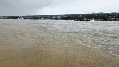
There is a possibility of a flood on rivers from Quang Tri to Lam Dong.
From tonight (November 6) to November 9, there is a possibility of a flood on rivers from Quang Tri to Lam Dong. During this flood, the flood peak on Tra Khuc River, Ve River, Se San River (Quang Ngai); Kon River (Gia Lai); Ba River, Ky Lo River, Srepok River (Dak Lak) will rise to level BĐ2-BĐ3, some rivers will rise above BĐ3; Bo River, Huong River (Hue City); Vu Gia-Thu Bon River (Da Nang City); Kien Giang River (Quang Tri); An Lao River, Lai Giang River (Gia Lai); Dinh Ninh Hoa River (Khanh Hoa), rivers in Lam Dong will rise to level BĐ1-BĐ2, some rivers will rise above BĐ2; Gianh River, Thach Han River (Quang Tri), Cai Nha Trang River (Khanh Hoa) will rise above BĐ1.
Risk of flooding in low-lying areas along rivers, urban areas, and densely populated areas in provinces/cities from Quang Tri to Lam Dong. High risk of flash floods on rivers and streams and landslides on steep slopes in provinces/cities from Quang Tri to Lam Dong.


The Ministry of National Defense mobilized over 268,000 officers and soldiers and 6 aircraft to respond to storm No. 13.
On the evening of November 6, information from the Office of the National Civil Defense Steering Committee stated that in order to be on standby and ready to perform rescue missions when storm No. 13 (storm Kalmaegi) makes landfall, the Ministry of National Defense has directed Military Region 4, Military Region 5 and Military Region 7 and other units to be ready to maintain 268,255 officers and soldiers (68,095 soldiers, 200,160 militiamen), along with 6,723 vehicles of all kinds, including 3,755 cars, 646 ships, 1,790 boats, canoes, 520 special vehicles and 6 airplanes.
Quang Ngai: Three people were swept away at sea, unable to reach shore when the storm was about to make landfall.
On the evening of November 6, the leader of the People's Committee of Ly Son Special Zone (Quang Ngai) said that 3 people were drifting at sea and had not yet reached shore when storm No. 13 was about to make landfall in the Central region.
Earlier that afternoon, Mr. DQC (44 years old) from Tay An Vinh village jumped into the sea for family reasons at Ly Son wharf. Afterwards, Mr. LVS (37 years old) from Tay An Hai village and Mr. PDQ (47 years old) from Tay An Vinh village used a basket to rescue the person who jumped off the bridge.
After rescuing Mr. DQC, due to the big waves, the three of them could not row the boat to shore. Immediately after the incident, the authorities mobilized Thanh Tam ship (VT0035) to search. At nearly 6 p.m., due to big waves and strong winds, the search had to be temporarily suspended.
Many localities let students stay home from school to avoid storm No. 13.
The Chairman of Khanh Hoa Provincial People's Committee requested the Department of Education and Training to direct educational institutions in the area to let students stay home from school on November 6 and 7 and during days of heavy rain and floods.
At the same time, units develop plans to organize make-up classes at appropriate times, ensuring the completion of the school year program as prescribed.
The Department of Education and Training of Quang Ngai province has requested the chairmen of the People's Committees of communes, wards, special zones, and educational institutions in the area to let students stay home from school from the afternoon of November 6 until further notice.
Students in Da Nang City also started their school break from the afternoon of November 6. The Department of Education and Training of Da Nang City requested units to monitor the actual situation to proactively decide on the return to school.
On November 6, the Department of Education and Training of Lam Dong province announced that it had issued a document giving the People's Committees of communes, wards, towns and units and schools under the department the authority to decide to let students stay home from school in places at risk of being unsafe due to the impact of storm No. 13. By the evening of November 6, localities in the Da Lat area (the center of Lam Dong province) had notified students of all levels to stay home from school to prevent and avoid storm No. 13 (international name: KALMAEGI).
Previously, the Department of Education and Training of Gia Lai province requested educational establishments in 58 communes and wards in the East of Gia Lai province and 8 communes in the West, including Dak Po, An Khe, Kong Chro, Kbang, Phu Thien, Ia Pa, Krong Pa, Ayun Pa to let students stay home from the afternoon of November 5 to November 7 to proactively prevent and avoid the storm.
On November 4, the Department of Education and Training of Dak Lak province issued an official dispatch requesting educational institutions in coastal communes and wards such as Song Cau, Xuan Dai, Binh Kien, Tuy Hoa, Phu Yen, Hoa Hiep, Xuan Loc, Xuan Canh, Tuy An Bac, Tuy An Dong, Tuy An Nam, O Loan, Hoa Xuan, Xuan Tho and some neighboring communes and wards to notify students to stay home from Wednesday afternoon (November 5) to the end of Friday (November 7).
Ly Son Special Zone begins to have heavy rain and strong winds
Storm No. 13 is approaching, Ly Son special zone, Quang Ngai province has started to have heavy rain and strong winds; authorities have evacuated many people to avoid the storm.
Information from Ly Son special economic zone, Quang Ngai province at 1:30 p.m. on November 6, said that the special economic zone began to experience heavy rain and strong winds.
The coastal area of Ly Son has heavy rain, wind gusts of level 6-7, sometimes reaching level 9. Waves continuously rise, white foam splashes onto the embankment and port area.
So far, local authorities have evacuated 130 households in dangerous coastal areas and fragile houses to safety.
Temporarily closing a section of the Da Nang – Quang Ngai highway to respond to storm No. 13
To proactively respond to storm No. 13, the Traffic Police Department announced a temporary road closure on the Da Nang - Quang Ngai expressway, from Km64 (Tam Ky intersection) to Km131+500 (Quang Ngai intersection), starting from 6:30 p.m. on November 6, until further notice.
Ships anchor to avoid storms

Proactively ensure safety of ships and reservoirs
According to the Border Guard Command, as of 6:30 a.m. on November 6, 61,475 vehicles/291,384 workers had been notified, counted and instructed about the location and direction of the storm; currently, no vehicles are operating in the danger zone. Localities that have issued sea bans include: Da Nang, Quang Ngai, Khanh Hoa, Gia Lai, Dak Lak and Lam Dong.
Regarding reservoirs, according to the report updated at 5:00 a.m. the same day, the water level at many large lakes in the Central and Central Highlands regions is high, many lakes have had to discharge to ensure safety. Some lakes have large discharge flows such as Huong Dien (Hue) 1,140 m³/s, Song Tranh 2 (Quang Nam) 1,481 m³/s, Ialy (Gia Lai) 939 m³/s, Song Ba Ha (Dak Lak) 440 m³/s.

From the evening of November 5 to the morning of November 6, the Central and Southern regions had moderate rain, heavy rain, and locally very heavy rain, with rainfall generally below 30mm; some places had higher rainfall such as: Xuan Forestry Farm (Can Tho) 126mm, Hiep Hung (Can Tho) 69mm, Dien Huong (Hue) 45mm.
It is forecasted that on November 6-7, from Da Nang to Dak Lak, there is a possibility of very heavy rain of 200-400mm, in some places over 600mm/period; from the area of South Quang Tri to Hue, Khanh Hoa and Lam Dong, there will be rain of 150-300mm, in some places over 450mm/period. From November 7-8, the rain will spread to Thanh Hoa to North Quang Tri, with common rainfall of 50-100mm, in some places over 200mm/period.
Floods on rivers in the Central region are slowly receding. The water level at 6:00 a.m. on November 6 at Le Thuy station (Kien Giang river, Quang Tri) was 2.29 m, 0.09 m above alert level 2; Phu Oc station (Bo river, Hue) was 3.65 m, 0.65 m above alert level 2; Vu Gia river (Da Nang) at Ai Nghia was 7.8 m, 0.2 m below alert level 2. It is forecasted that from November 6-9, many rivers from Quang Tri to Lam Dong are likely to experience a new flood, with the flood peak reaching alert levels 2-3, and in some places exceeding alert level 3.
Emergency response deployment
On November 6, Deputy Prime Minister Tran Hong Ha directly chaired a meeting with ministries, branches and localities from Quang Tri to Khanh Hoa at the Forward Command Center to direct emergency response to storm No. 13.
Previously, the Prime Minister issued Official Dispatch No. 208/CD-TTg (dated November 4) requesting localities from Ha Tinh to Khanh Hoa to proactively develop plans to prevent, avoid, respond, and ensure the safety of dyke systems, reservoirs, coastal and mountainous residential areas.
The National Steering Committee for Civil Defense, the Ministry of Agriculture and Environment, the Ministry of Industry and Trade, the Ministry of Foreign Affairs and relevant ministries and branches have continuously issued urgent dispatches and instructions; at the same time, working delegations of the Ministry of Agriculture and Environment led by Deputy Minister Nguyen Hoang Hiep have inspected the situation in Da Nang, Quang Ngai and Gia Lai.
The Department of Dyke Management and Natural Disaster Prevention and Control organized a 24/7 duty, closely monitoring the developments of storms, floods and rains; coordinated with Zalo Vietnam to send warning messages and boat safety instructions to 6 million people in coastal communes from Ha Tinh to Binh Thuan.
Localities have proactively deployed the work of evacuating people, operating reservoirs, and arranging emergency forces on standby. Gia Lai province has evacuated 2,337 households/7,097 people from dangerous areas; Khanh Hoa and Gia Lai have allowed students to stay home from school on November 6-7 to ensure safety.
On the evening of November 5, Deputy Minister of Agriculture and Environment Nguyen Hoang Hiep and the People's Committee of Gia Lai province held a meeting with departments, branches, sectors and communes and wards on storm prevention work No. 13.
Deputy Minister Nguyen Hoang Hiep informed that storm No. 13 is very strong, moving quickly, increasing in intensity, at present, the wind speed shows no signs of decreasing. The storm's path will be straight towards Quy Nhon. From noon on November 6, heavy rain will begin. It is forecasted that on the evening of November 6, storm No. 13 will make landfall, encountering high tides, so the coastal areas are likely to have a very high water level, up to 7-8 m.
"We require hydropower plants and irrigation reservoirs to discharge water to the maximum level from now until the afternoon of November 6 to ensure the safety of downstream areas during storms and floods. All evacuation activities must be completed before 12 noon on November 6. In particular, from 6 pm on November 6, people are absolutely not allowed to go out on the streets in the Eastern region," Deputy Minister Nguyen Hoang Hiep emphasized.
Also according to Deputy Minister Nguyen Hoang Hiep, in addition to Quy Nhon being directly affected by the storm, in the west of Gia Lai province, the wind can gust to level 9 to level 11. Therefore, this area also needs to immediately deploy timely response solutions.
Source: https://baolamdong.vn/bao-so-13-suy-yeu-thanh-ap-thap-tren-khu-vuc-nam-lao-mua-lon-tu-thanh-hoa-den-da-nang-400916.html
![[Photo] Hanoi: Long Bien residents brave the rain to go to work and school amid traffic jams due to bridge closures from early morning](https://vphoto.vietnam.vn/thumb/1200x675/vietnam/resource/IMAGE/2025/11/07/1762485038077_dji-0206-1506-jpg.webp)


Comment (0)