
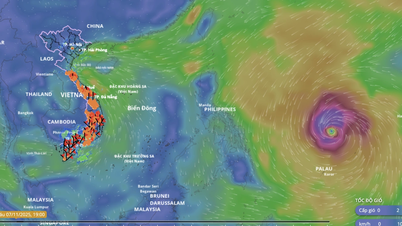
The storm is moving west-northwest at a speed of 30km/h.
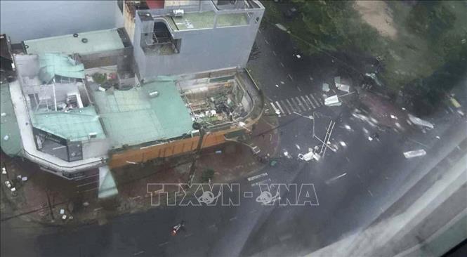
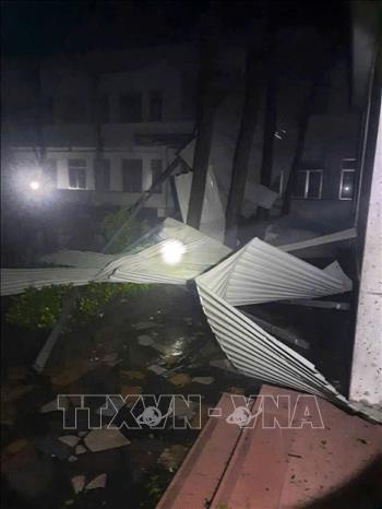
Due to the impact of the storm, at Ly Son station (Quang Ngai), there were strong winds of level 8, gusts of level 10; Hoi An (Da Nang) strong winds of level 8, gusts of level 10; Dung Quat (Quang Ngai) strong winds of level 8, gusts of level 10; Hoa Nhon Dong ( Gia Lai ) strong winds of level 8, gusts of level 10; Phu Cat (Gia Lai) strong winds of level 9, gusts of level 13; An Nhon (Gia Lai) strong winds of level 10, gusts of level 14; Hoai Nhon (Gia Lai) strong winds of level 7, gusts of level 9; Quy Nhon (Gia Lai) strong winds of level 10, gusts of level 13; Canh Thuan (Gia Lai) strong winds of level 7, gusts of level 10; Son Hoa (Dak Lak) strong winds of level 7, gusts of level 10; Tuy Hoa (Dak Lak) strong winds of level 6, gusts of level 9; Song Cau (Dak Lak) strong winds of level 9; An Khe (Gia Lai) strong wind level 6, gust level 8; Cheo Reo (Gia Lai) strong wind level 8, gust level 10; M Drak (Dak Lak) strong wind level 7, gust level 10. In the area from Hue city to Khanh Hoa, there was heavy rain, some places over 170mm such as: Xuan Son Nam station (Dak Lak) 243mm, Dak Pling (Gia Lai) 185mm, Tra Thanh (Quang Ngai) 203mm, ...
At 10 p.m., the eye of the storm was at about 13.8 degrees North latitude; 108.3 degrees East longitude, on the mainland of Gia Lai-Dak Lak province. The strongest wind near the eye of the storm was level 9 (75-88 km/h), gusting to level 11. Moving in the West Northwest direction, speed about 30 km/h.
By 10:00 a.m. on November 7, the storm was moving west-northwest at a speed of 30 km/h, with winds below level 6, and weakening into a low pressure area. The affected area is the sea from South Da Nang to Dak Lak (including Ly Son special zone); the mainland from Quang Ngai to Dak Lak with a level 3 disaster risk level.
Due to the storm's influence, on the night of November 6, the sea area from South Da Nang to Dak Lak (including Ly Son special zone) had strong winds of level 6-8, gusts of level 10, waves 3-5 high; rough seas.
Coastal areas from Hue city to Dak Lak have storm surges of 0.5-1m. The highest sea level is 1m in Thuan An, 1.2m in Son Tra, 1.3m in Hoi An, 1.5m in Dung Quat, 1.2m in Quy Nhon, and 1.1m in Tuy Hoa.
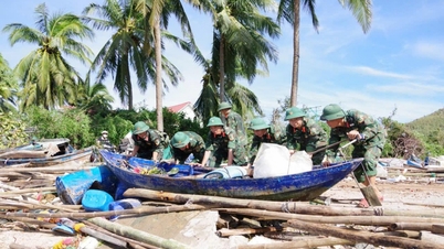
Warning, coastal areas from Hue city to Dak Lak are warned of rising sea levels accompanied by large waves causing flooding in low-lying areas, waves overflowing dikes, coastal roads, coastal erosion, slowing down flood drainage in the area. All ships, boats, and aquaculture areas in the above-mentioned dangerous areas are strongly affected by storms, whirlwinds, strong winds, large waves, and rising sea levels.
On the night of November 6, on land from Quang Ngai to Dak Lak, strong winds of level 6-7, near the storm's eye, strong winds of level 8-9, gusting to level 11.
From the night of November 6-7, the area from South Quang Tri to Dak Lak will have very heavy rain with common rainfall of 100-250mm, locally over 300mm; Khanh Hoa and Lam Dong will have heavy rain with common rainfall of 70-150mm, locally over 250mm. From November 8, heavy rain in the above areas will tend to decrease.
From November 7-8, the area from Thanh Hoa to Northern Quang Tri will have moderate to heavy rain with common rainfall of 50-150mm, locally very heavy rain over 200mm.
Warning of risk of heavy rain over 200mm/3h.
Director of the National Center for Hydro-Meteorological Forecasting Mai Van Khiem said that the path and impact of storm No. 13 is similar to storm No. 12 - (Damrey) in 2017 and storm No. 9 (Molave) in 2020, but storm No. 13 causes heavier rain in the area from Da Nang city to Dak Lak.
Storm No. 12 - (Damrey) in 2017, when making landfall in the provinces of Phu Yen and Khanh Hoa, had a strong intensity of level 9, causing heavy rain in the Hue - Khanh Hoa area from 150 - 250mm, Gia Lai - Dak Lak about 80 - 150mm; some places had heavier rain such as: Nam Dong (Hue) 321mm; Tam Ky, Tien Phuoc (old Quang Nam ) 280mm; Ba To (Quang Ngai) 338mm; Son Giang (Quang Ngai) 382mm; An Nhon (Gia Lai) 296mm, Quy Nhon (Gia Lai) 295mm; An Khe (Gia Lai) 266mm, Krong Pa (Gia Lai) 237mm;...
Storm No. 9 (Molave) in 2020 when making landfall in the Quang Ngai - Da Nang area had a strong intensity of level 11 - 12, gusting to level 14. The storm caused heavy rain from 150-400mm in many places from Nghe An to Dak Lak, some stations measured rainfall of over 550mm.
Beware of flash floods and landslides from Quang Tri to Lam Dong
The National Center for Hydro-Meteorological Forecasting said: From 11:30 p.m. on November 6 to 4:30 a.m. on November 7, the provinces/cities from Quang Tri to Lam Dong will continue to have rain. There is a risk of flash floods and landslides in the above-mentioned areas.
Specifically, the common accumulated rainfall from Quang Tri to Da Nang, Khanh Hoa and Lam Dong is 40-70mm, some places over 110mm; Quang Ngai, Gia Lai and Dak Lak is 50-90mm, some places over 170mm.
Risk warning: flash floods on small rivers and streams, landslides on steep slopes in many communes/wards: Ta Rut; La Lay; A Doi, Ba Long, Dakrong, Khe Sanh, Lia (Quang Tri province).
In Hue city, there are communes and wards at risk of flash floods and landslides including: A Luoi 1, Chan May - Lang Co, Hung Loc, Loc An, Phu Loc; A Luoi 2, A Luoi 3, A Luoi 4, A Luoi 5, Binh Dien, Khe Tre, Long Quang, Nam Dong, Phong Dien Ward, Vinh Loc; Huong Tra, Kim Long, Phong Thai, Phu Bai.
Da Nang City has communes and wards at risk of flash floods and landslides, including: Phuoc Chanh, Phuoc Thanh, Tra Giap, Tra Leng, Tra My, Tra Tap, Tra Van; Ba Na, Ben Giang, Dong Duong, Duc Phu, Ha Nha, Hiep Duc, Kham Duc, Lanh Ngoc, Nam Tra My, Nong Son, Son Tra, Phu Ninh, Phu Thuan, Phuoc Hiep, Phuoc Nang, Phuoc Tra, Que Phuoc, Son Cam Ha, Tam My, Thang Phu, Thanh Binh, Thuong Duc, Tien Phuoc, Tra Lien, Tra Tan, Viet An; Avuong, Ben Hien, Chien Dan, Dac Pring, Dong Giang, Duy Xuyen, Hoa Tien, Hoa Vang, Hung Son, La Dee, La Ee, Nam Giang, Nui Thanh, An Khe, Hai Van, Hoa Khanh, Lien Chieu, Que Son, Que Son Trung, Song Kon, Song Vang, Tam Anh, Tam Xuan, Tay Giang, Tay Ho, Thanh My, Thu Bon, Tra Doc, Tra Linh.
For Quang Ngai province, communes and wards at risk of flash floods and landslides include: Ba Dinh, Ba To, Ba Vinh, Dak Plo, Mang Den, Minh Long, Ngoc Linh, Son Linh, Son Tay, Son Tay Ha, Son Tay Thuong, Tay Tra, Tay Tra Bong, Thanh Bong; Ba Dong, Ba To, Ba Vi, Ba Xa, Ca Dam, Dak Ha, Dak Ro Wa, Dak Ui, Dang Thuy Tram, Dinh Cuong, Ia Chim, Ia Dal, Ia Toi, Khanh Cuong, Kon Braih, Kon Plong, Mang But, Mang Ri, Mo Duc, Mo Rai, Ngok Bay, Ngok Reo, Nguyen Nghiem, Dak Bla, Dak Cam, Duc Pho, Kon Tum, Sa Huynh, Tra Cau, Phuoc Giang, Sa Binh, Sa Thay, Son Ha, Son Ha, Son Ky, Son Mai, Son Thuy, Thien Tin, Tra Bong, Tra Giang, Ve Giang, Xop, Ya Ly; Ba Gia, Binh Chuong, Binh Minh, Bo Y, Dak Koi, Dak Long, Dak Mar, Dak Mon, Dak Pek, Dak Pxi, Dak Rve, Dak Sao, Dak To, Dak To Kan, Dong Tra Bong, Duc Nong, Kon Dao, Lan Phong, Nghia Giang, Ngok Tu, Ro Koi, Sa Loong, Son Tinh, Truong Giang, Tu Mo Rong.
Gia Lai province has communes and wards at risk of flash floods and landslides including: Al Ba, An Hao, An Hoa, An Nhon Tay, Bo Ngoong, Canh Lien, Canh Vinh, Cho Long, Chu A Thai, Chu Prong, Chu Se, Dak Song, Ia Boong, Ia Hiao, Ia Hru, Ia Ko, Ia Le, Ia Pa, Ia Rbol, Ia RSai, Ia Sao, Ia Tor, Ia Tul, Kon Chieng, Kong Chro, Lo Pang, An Binh, An Nhon Nam, Ayun Pa, Bong Son, Quy Nhon Tay, Phu Thien, Phu Tuc, Po To, Sro, Uar, Van Canh, Vinh Quang, Vinh Thinh; An Lao, An Toan, An Tuong, An Vinh, Ayun, Bau Can, Binh An, Chu Krey, Chu Puh, Cuu An, Dak Po, Duc Co, Gao, Hoai An, Hoi Son, Hra, Ia Bang, Ia Dreh, Ia Khuol, Ia Krai, Ia Krel, Ia Ly, Ia Phi, Ia Pia, Ia Puch, KDang, Kim Son, Mang Yang, Ngo May, An Khe, An Phu, Hoai Nhon, Hoai Nhon Bac, Hoai Nhon Dong, Hoai Nhon Nam, Hoai Nhon Tay, Hoi Phu, Pleiku, Quy Nhon, Quy Nhon Bac, Quy Nhon Dong, Quy Nhon Nam, Tam Quan, Phu Cat, Phu My Dong, Tay Son, Tuy Phuoc, Tuy Phuoc Bac, Tuy Phuoc Dong, Tuy Phuoc Tay, Van Duc, Vinh Thanh, Xuan An, Ya Hoi, Ya Ma; An Luong, Bien Ho, Binh Duong, Binh Hiep, Binh Khe, Binh Phu, Cat Tien, Chu Pah, Dak Doa, Dak Rong, Dak Somei, De Gi, Hoa Hoi, Ia Chia, Ia Dok, Ia Dom, Ia Grai, Ia Hrung, Ia Lau, Ia Mo, Ia Nan, Ia O, Ia Pnôn, KBang, Kon Gang, Kong Bo La, Krong, Dien Hong, Thong Nhat, Phu My, Phu My Bac, Phu My Nam, Phu My Tay, Son Lang, To Tung, Vinh Son.
Dak Lak province has communes and wards at risk of flash floods and landslides including: Cu M'gar, Cu Pong, Cu Yang, Cuor Dang, Dak Lieng, Dak Phoi, Dang Kang, Dlie Ya, Dong Xuan, Duc Binh, Ea Ba, Ea Drang, Ea Drong, Ea Hiao, Ea Khal, Ea Knuec, Ea O, Ea Pal, Ea Phe, Ea Rieng, Ea Tul, Ea Wy, Hoa My, Hoa Phu, Hoa Thinh, Hoa Xuan, Krong Bong, Krong Buk, Krong Nang, Krong Pac, Lien Son Lak, Binh Kien, Buon Ho, Buon Ma Thuot, Cu Bao, Ea Kao, Song Cau, Tan An, Tan Lap, Thanh Nhat, Xuan Dai, Phu Hoa 1, Phu Hoa 2, Phu Mo, Pong Drang, Quang Phu, Son Hoa, Son Thanh, Song Hinh, Suoi Trai, Tam Giang, Tan Tien, Tay Son, Tuy An Bac, Tuy An Nam, Tuy An Tay, Van Hoa, Vu Bon, Xuan Canh, Xuan Lanh, Xuan Loc, Xuan Phuoc, Xuan Tho; Buon Don, Cu M'ta, Cu Prao, Cu Pui, Dray Bhăng, Dur KMăl, Ea H'Leo, Ea Kar, Ea Kiết, Ea Kly, Ea Knop, Ea Ktur, Ea Ly, Ea M'Droh, Ea Na, Ea Ning, Ea Nuôl, Ea Rôk, Ea Súp, Ea Wer, Hoa Son, Krông Á, Krông Ana, Krông Nô, M'Drắk, Dong Hoa, Tuy Hòa, Phu Xuan; Ea Bung, Ea Trang, Ia Lộp, Ia RVê, Nam Ka, Yang Mao.
Along with that, Khanh Hoa province has communes and wards at risk of flash floods and landslides including: Dai Lanh, Tu Bong, Van Hung, Van Thang; Bac Ninh Hoa, Dien Dien, Hoa Tri, Nam Ninh Hoa, Bac Nha Trang, Dong Ninh Hoa, Hoa Thang, Nam Nha Trang, Nha Trang, Ninh Hoa, Tay Nha Trang, Tan Dinh, Tay Ninh Hoa, Van Ninh.
In addition, Lam Dong province has communes and wards at risk of flash floods and landslides, including: Dam Rong 3, Dam Rong 4; Cu Jut, Dak Mil, Dak Song, Dak Wil, Dam Rong 1, Dam Rong 2, Duc Lap, Nam Da, Nam Dong, Bac Gia Nghia, Lang Biang - Da Lat, Quang Hoa, Quang Son, Ta Dung, Thuan An; Bao Lam 4, Bao Lam 5, Dak Sak, Duc An, Krong No, Lac Duong, Nam Ban Lam Ha, Nam Ha Lam Ha, Nam Nung, Nhan Co, Cam Ly - Da Lat, Dong Gia Nghia, Lam Vien - Da Lat, Nam Gia Nghia, Xuan Huong - Da Lat, Quang Khe, Quang Phu, Thuan Hanh, Truong Xuan, Tuy Duc.
Level of natural disaster risk due to flash floods, landslides, land subsidence due to heavy rain or level 1 flow.
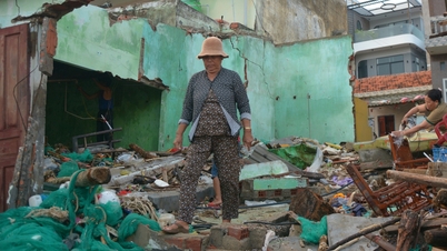
Flash floods and landslides can have very negative impacts on the environment, threaten people's lives; cause local traffic congestion, affect the movement of vehicles; destroy civil and economic works, causing damage to production and socio-economic activities.
The hydrometeorological agency recommends that local authorities pay attention to reviewing bottlenecks and vulnerable locations in the area to have prevention and response measures.
Source: https://baotintuc.vn/xa-hoi/bao-so-13-suy-yeu-tren-dat-lien-gia-lai-dak-lak-nhung-tiep-tuc-gay-mua-rat-to-20251107055526242.htm


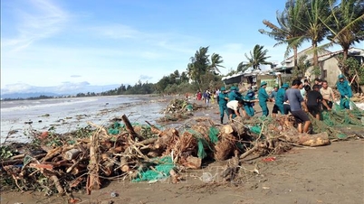
![[Photo] Da Nang: Hundreds of people join hands to clean up a vital tourist route after storm No. 13](https://vphoto.vietnam.vn/thumb/1200x675/vietnam/resource/IMAGE/2025/11/07/1762491638903_image-3-1353-jpg.webp)


Comment (0)