
 |
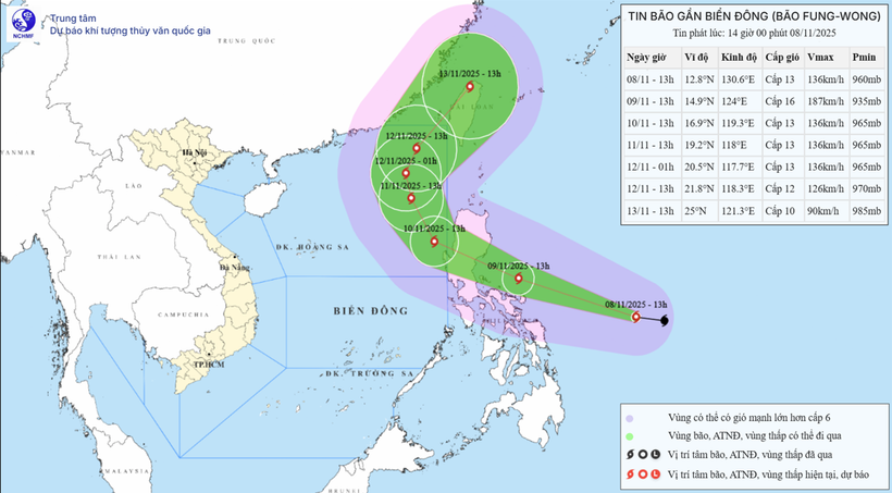
| Storm movement direction. (Source: Center for Hydro-Meteorological Forecasting) |
On the afternoon of November 8, the National Center for Hydro-Meteorological Forecasting informed that a strong storm is currently active in the eastern sea, central Philippines with the international name Fung-wong.
According to forecasts, on January 9, the intensity of this storm is likely to reach super typhoon level and on the morning of November 10, it is likely to move into the East Sea.
To better understand the developments of this storm, VNA reporter spoke with Head of Weather Forecast Department, National Center for Hydro-Meteorological Forecasting Nguyen Van Huong.
- Could you tell us how typhoon Fung-wong is progressing?
Mr. Nguyen Van Huong: At 1:00 p.m. on November 8, the center of the storm was at about 12.8 degrees North latitude; 130.6 degrees East longitude. The strongest wind near the center of the storm was level 13 (134-149 km/h), gusting to level 16. Moving in the West Northwest direction at a speed of about 30 km/h.
It is forecasted that around the morning of November 10, storm Fung-wong is likely to move into the eastern sea area of the North East Sea.
- What are the characteristics of this storm that need to be noted, sir?
Mr. Nguyen Van Huong: Currently, typhoon Fung-wong is operating in a very favorable environment with high sea surface temperatures of 29-30 degrees Celsius, low vertical wind shear... so the storm's intensity will continue to increase and is likely to reach super typhoon level on November 9. When entering the sea area southeast of Luzon Island (Philippines), encountering unfavorable environmental conditions, the storm is likely to weaken in intensity.
Around the morning of November 10, Typhoon Fung-wong is likely to move into the eastern sea of the North East Sea and become the 14th typhoon active in the East Sea in 2025. At this time, the subtropical pressure branch in the north (the guiding stream for the storm to move) weakens in intensity and expands further south of the storm. This leads to the storm tending to move more to the north. When moving to higher latitudes, the storm will enter the guiding stream of the upper westerly wind zone, so it is likely to change direction to the northeast and leave the East Sea.
Normally, at the end of the season, typhoons often move west, even west-southwest, and make landfall in the southern central provinces. However, typhoon Fung-wong moved north and went out. This is the unusual point of this typhoon.
- Can you comment on the impact of this storm?
Mr. Nguyen Van Huong: Due to the influence of the storm combined with the cold air strengthening to the East, from the night of November 8, the eastern sea area of the North East Sea will have strong northeast winds of level 6-7, gusting to level 8-9. From the night of November 9, the wind in this sea area will strengthen to level 8-9; the area near the storm center will be strong at level 10-12, gusting to level 14-15, waves 3-5m high, then increasing to 6-8m, the sea will be very rough.
Around the morning of November 10, storm Fung-wong is likely to move into the East Sea with a level 13 intensity, gusting to level 16, and maintain its intensity as it moves northward. Therefore, during November 10-12, the eastern sea area of the North East Sea is likely to be affected by strong storm winds of level 11-13, gusting to level 16, waves 8-10m high, and rough seas.
All vessels operating in the above mentioned danger zones are susceptible to storms, strong winds and large waves.
Thank you very much!
According to VNA/Vietnam+
Source: https://baoquangtri.vn/xa-hoi/202511/bao-fung-wong-co-kha-nang-di-chuyen-vao-bien-dong-vao-sang-1011-23d4a51/

![[Photo] Cutting hills to make way for people to travel on route 14E that suffered landslides](https://vphoto.vietnam.vn/thumb/1200x675/vietnam/resource/IMAGE/2025/11/08/1762599969318_ndo_br_thiet-ke-chua-co-ten-2025-11-08t154639923-png.webp)


![[Video] Hue Monuments reopen to welcome visitors](https://vphoto.vietnam.vn/thumb/402x226/vietnam/resource/IMAGE/2025/11/05/1762301089171_dung01-05-43-09still013-jpg.webp)


Comment (0)