

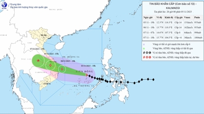
Path of storm KALMAEGI on the morning of October 4
According to the National Center for Hydro-Meteorological Forecasting, at 7:00 a.m. on November 4, the center of the storm was located at about 10.7 degrees North latitude; 123.5 degrees East longitude, in the central region of the Philippines. The strongest wind near the center of the storm was level 13 (134-149 km/h), gusting to level 16. Moving in the West Northwest direction at a speed of about 20 km/h.
The National Center for Hydro-Meteorological Forecasting also stated that after entering the East Sea, the storm will move very quickly, about 20-25 km/h. With a stable direction moving in the West-Northwest direction and a fast speed, it is forecast to make landfall in our country from the night of November 6 to the morning of November 7.
In terms of intensity, after entering the East Sea, the storm will continue to strengthen. By 7am tomorrow morning (November 5), while operating in the central East Sea, the storm will be at level 13, gusting to level 16.
During the day and night of November 5, the storm continued to strengthen. At 7:00 a.m. on November 6, while operating in the Central East Sea, off the coast of Gia Lai province (formerly Binh Dinh), the storm strengthened to level 14, gusting to level 17.
It is forecasted that during the day and night of November 6, the storm will gradually move towards the sea area from Quang Ngai to Dak Lak (formerly Phu Yen ) with a slight decrease in intensity, then enter our mainland with a strong intensity of level 11-12, gusting to level 14-15.
At 7:00 a.m. on November 7, when it entered the mainland from Quang Ngai to Dak Lak , the storm still maintained its intensity of level 10-11, gusting to level 13. During the day and night of November 7, the storm entered the mainland, moved to Southern Laos and Thailand, weakened into a tropical depression, then a low pressure area. At 7:00 a.m. on November 8, the center of the low pressure area was over Eastern Thailand and gradually dissipated.
According to the National Center for Hydro-Meteorological Forecasting, unlike the recent super typhoon RAGASA or typhoon FENGSENG (typhoon No. 12), typhoon KALMAEGI is less likely to encounter unfavorable conditions such as cold, dry air and strong wind shear to weaken quickly. Therefore, this could be the strongest typhoon to make landfall in our country this year.
Due to the strong intensity of the storm, the area of influence is forecast to be very large, the area of strong winds may extend from Da Nang to Khanh Hoa. Meanwhile, the area of heavy rain may extend from Quang Tri to Dak Lak, lasting from the night of November 6 to November 9. In addition, the meteorological agency is paying special attention to the possibility of thunderstorms before the storm arrives.
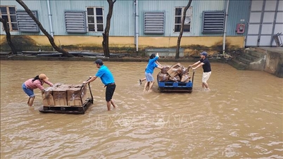
Floods on rivers in the Central region are at high levels, causing widespread flooding.
Currently, floods on rivers in the Central region are at high levels, widespread flooding is occurring in many localities. Through monitoring and analysis of the current state of the weather system and forecast products, it is shown that in the coming days, the mainland as well as the East Sea will continue to be affected by a number of dangerous natural disasters.
Due to the influence of continuously strengthened cold air, combined with many factors (tropical convergence zone, low pressure area in the South China Sea, high-altitude easterly wind disturbance), until the end of November 4, the area from Ha Tinh province to Hue city will continue to have heavy to very heavy rain with common rainfall of 150-250 mm, locally over 400 mm, from the afternoon of November 4, 2025 to November 6, 2025, rain in the above area is likely to decrease.
Regarding the flood situation, by the end of November 4, floods on the Bo River, Huong River (Hue City), Vu Gia-Thu Bon River (Da Nang City) fluctuated at a high level, then gradually decreased and fluctuated at level BĐ2 and above BĐ2; on the Kien Giang River (Quang Tri Province) fluctuated above BĐ3. On the Thach Han River (Quang Tri Province), the possibility of flooding was at level BĐ2-BĐ3.
Thu Cuc
Source: https://baochinhphu.vn/bao-kalmaegi-di-chuyen-nhanh-cuong-do-manh-khi-vao-bien-dong-102251104101922634.htm


![[Photo] Opening of the 14th Conference of the 13th Party Central Committee](https://vphoto.vietnam.vn/thumb/1200x675/vietnam/resource/IMAGE/2025/11/05/1762310995216_a5-bnd-5742-5255-jpg.webp)


![[Photo] Panorama of the Patriotic Emulation Congress of Nhan Dan Newspaper for the period 2025-2030](https://vphoto.vietnam.vn/thumb/1200x675/vietnam/resource/IMAGE/2025/11/04/1762252775462_ndo_br_dhthiduayeuncbaond-6125-jpg.webp)


Comment (0)