
 |
| The movement of storm No. 13 at 5:00 a.m. on November 6. (Photo: VNA) |
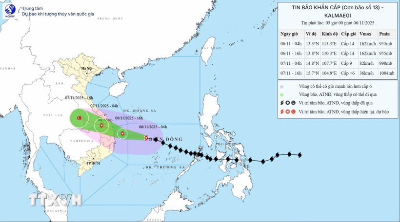
According to the National Center for Hydro-Meteorological Forecasting, storm No. 13 maintains its direction of movement and intensity.
The storm moved faster and was about 450km East Southeast of Quy Nhon ( Gia Lai ).
At 4:00 a.m. on November 6, the center of the storm was at about 13.3 degrees North latitude; 113.3 degrees East longitude, with the strongest wind near the center of the storm at level 14 (150-166 km/h), gusting to level 17. Moving in the West Northwest direction, at a speed of about 30 km/h.
It is forecasted that by 4 p.m. on November 6, the storm will be about 120km east of Quy Nhon (Gia Lai), with the strongest wind at level 14, gusting to level 17, moving in the West Northwest direction at a speed of about 30km/h.
The affected area is the middle of the East Sea, the sea area from Quang Ngai to Dak Lak (including Ly Son special zone), level 4 natural disaster risk.
The sea area from South Quang Tri - Da Nang city (including Cu Lao Cham island) and Khanh Hoa; mainland South Quang Tri - Da Nang city, the East of the provinces from Quang Ngai - Dak Lak to the North of Khanh Hoa province with level 3 natural disaster risk.
Next, at 4:00 a.m. on November 7, the storm in the western border area of Quang Ngai province - Southern Laos, the strongest wind is level 9, gusting to level 11, moving in the West Northwest direction at a speed of about 25 km/h.
The affected area is the sea from Quang Ngai-Dak Lak (including Ly Son special zone), the eastern mainland from Quang Ngai-Gia Lai, level 4 natural disaster risk.
The sea area from South Quang Tri - Da Nang city (including Cu Lao Cham island) and Khanh Hoa; mainland South Quang Tri to Da Nang city, West Quang Ngai province to Gia Lai, East Dak Lak province and North Khanh Hoa province with level 3 natural disaster risk.
 |
| Forces of Regiment 6, Hue City Military Command are ready to respond to storm No. 13. (Photo: Mai Trang/VNA) |
Then, at 4:00 p.m. on November 7, the storm in the eastern region of Thailand, with winds below level 6, moved west-northwest at a speed of about 25 km/h, moved inland and weakened into a tropical depression, then a low pressure area.
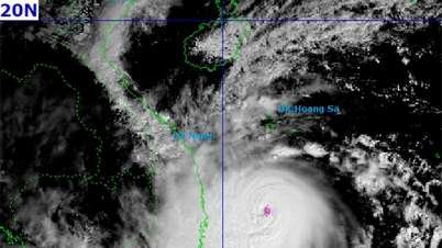
Due to the impact of the storm, the central East Sea area has strong winds of level 8-11, the area near the storm's eye has strong winds of level 12-14, gusts of level 17, waves 5-7m high, the area near the storm's eye has waves of 8-10m high; the sea is very rough.
From the morning of November 6, the sea area from South Quang Tri to Khanh Hoa (including Ly Son special zone, Cu Lao Cham island) will have winds gradually increasing to level 6-7, then increasing to level 8-11, waves 3-6m high, the area near the storm center will have strong winds of level 12-14, gusts of level 17, waves 7-9m high; the sea will be very rough.
Warning from the afternoon of November 6, coastal areas from Hue city to Dak Lak should be on guard against sea level rise of 0.4-0.8m accompanied by large waves causing flooding in low-lying areas, waves overflowing dikes, coastal roads, coastal landslides, slowing down flood drainage in the area.
All ships, boats, and aquaculture areas in the above-mentioned dangerous areas are strongly affected by storms, whirlwinds, strong winds, big waves, and rising sea levels.
On land from the South of Da Nang city to Dak Lak, winds gradually increase to level 6-7, then increase to level 8-9, in the area near the storm's eye, winds will increase to level 10-12 (focusing on the East of Quang Ngai-Gia Lai provinces), gusting to level 14-15; in the area from the South of Quang Tri to the North of Da Nang city and the North of Khanh Hoa province, winds will increase to level 6-7, gusting to level 8-9.
 |
| Soldiers help people put sandbags on their roofs to prevent them from being blown away by storm winds. (Photo: VNA) |
From the evening and night of November 6, in the West of the provinces from Quang Ngai to Gia Lai, the wind will gradually increase to level 6-7, near the storm's eye, it will be level 8-9, gusting to level 11.
From November 6-7, the area from Da Nang city to Dak Lak will have very heavy rain with common rainfall of 200-400 mm/period, locally over 600 mm/period; the area from South Quang Tri to Hue city, Khanh Hoa and Lam Dong will have heavy rain with common rainfall of 150-300 mm/period, locally over 450 mm/period. From November 8, heavy rain in the above areas will tend to decrease.
From November 7-8, the Northern Quang Tri-Thanh Hoa region will have moderate to heavy rain with common rainfall of 50-150 mm/period, locally very heavy rain over 200 mm/period.
Warning of risk of heavy rain over 200 mm/3 hours
Due to the influence of the wide storm circulation, it is necessary to guard against the risk of thunderstorms, tornadoes and strong gusts of wind both before and during the storm's landfall.
Director of the National Center for Hydro-Meteorological Forecasting Mai Van Khiem said the path and impact of storm No. 13 is similar to storm No. 12 (Damrey) in 2017 and storm No. 9 (Molave) in 2020, but storm No. 13 will cause heavier rain in the area from Da Nang city to Dak Lak.
Weather in regions day and night 11/6
Northwest
- Rain in some places, cold morning and night, sunny afternoon. Light wind.
- Lowest temperature 18-21 degrees Celsius, some places below 17 degrees Celsius. Highest temperature 25-28 degrees Celsius.
Northeast
- Rain in some places, cold in the morning and at night, sunny in the afternoon. North to Northeast wind level 2-3.
- Lowest temperature 18-21 degrees Celsius, in mountainous areas some places below 17 degrees Celsius. Highest temperature 24-27 degrees Celsius, some places above 27 degrees Celsius.
Hanoi City
- No rain, cold morning and night, sunny afternoon. North to Northeast wind level 2-3.
- Lowest temperature 19-21 degrees Celsius. Highest temperature 25-27 degrees Celsius.
Provinces and cities from Thanh Hoa to Hue
- In the North, there will be rain in some places during the day and scattered rain at night. In the South, there will be showers and thunderstorms, locally heavy rain in some places. From the afternoon, there will be moderate rain, heavy rain and thunderstorms, locally very heavy rain in some places. During thunderstorms, there is a possibility of tornadoes, lightning and strong gusts of wind. In the morning and at night, the weather will be cold. In the afternoon, the wind will gradually increase to level 6-7, gusting to level 8-9. The wind from the North to the Northwest will be level 3.
- Lowest temperature 19-22 degrees Celsius. Highest temperature 24-27 degrees Celsius.
South Central Coast
- There will be showers and thunderstorms, with some places experiencing heavy rain; from the afternoon there will be heavy to very heavy rain, with the possibility of tornadoes, lightning, and strong gusts of wind during thunderstorms. Northwest wind level 3-4, gradually increasing to level 6-7 in the afternoon, then increasing to level 8-9, near the storm center level 10-12, gusting to level 14-15.
- Lowest temperature 22-25 degrees Celsius. Highest temperature in the North 24-26 degrees Celsius; in the South 27-29 degrees Celsius.
Central Highlands
- There will be showers and thunderstorms, locally heavy rain; from the afternoon there will be heavy to very heavy rain, with the possibility of tornadoes, lightning and strong gusts of wind in thunderstorms. Northwest wind level 3-4, in the North at night the wind will gradually increase to level 6, gusting to level 8.
- Lowest temperature 19-22 degrees Celsius. Highest temperature 23-26 degrees Celsius.
Southern Vietnam
- There will be showers and thunderstorms in some places; in the afternoon and evening there will be scattered showers and thunderstorms, locally heavy rain in some places, in thunderstorms there is a possibility of tornadoes, lightning and strong gusts of wind.
- Lowest temperature 23-26 degrees Celsius. Highest temperature 29-32 degrees Celsius.
Ho Chi Minh City
- There will be showers and thunderstorms in some places; in the afternoon and evening there will be scattered showers and thunderstorms, locally heavy rain in some places, in thunderstorms there is a possibility of tornadoes, lightning and strong gusts of wind.
- Lowest temperature 23-25 degrees Celsius. Highest temperature 30-32 degrees Celsius.
According to VNA/Vietnam+
Source: https://baoquangtri.vn/xa-hoi/202511/bao-so-13-di-chuyen-nhanh-hon-chi-con-cach-quy-nhon-khoang-450km-b507663/


![[Photo] Closing of the 14th Conference of the 13th Party Central Committee](https://vphoto.vietnam.vn/thumb/1200x675/vietnam/resource/IMAGE/2025/11/06/1762404919012_a1-bnd-5975-5183-jpg.webp)


Comment (0)