
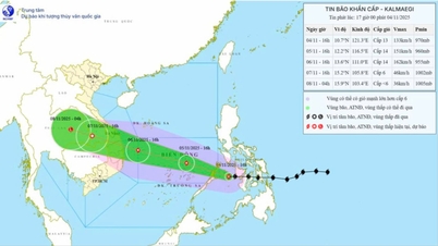
At 7:00 a.m., the center of the storm was at about 11.4 degrees North latitude; 118.9 degrees East longitude, about 500 km east of Song Tu Tay island. The strongest wind near the center of the storm was level 13 (134-149 km/h), gusting to level 16. The storm moved in a West Northwest direction at a speed of about 20 km/h.

Forecast for the next 24–72 hours
- On the sea
From the morning of November 6, the Central East Sea area (including the sea area north of Truong Sa special zone) has strong winds of level 8-11, the area near the storm's eye has strong winds of level 12-14, gusts of level 17, waves 5-7m high, the area near the storm's eye has waves of 8-10m high, and the sea is very rough.
The sea area from Da Nang to Khanh Hoa (including Ly Son special zone) will have winds gradually increasing to level 6-7, then increasing to level 8-11, the area near the storm center will have strong winds of level 12-14, gusting to level 17; waves 4-6m high, the area near the storm center will have waves of 6-8m high.
Storm surge in coastal areas from Thua Thien Hue to Dak Lak could be 0.3–0.6 m high, posing a risk of flooding, dike overtopping and coastal erosion.
- On land
From the evening of November 6, on the mainland along the coast from South Quang Tri to Da Nang, the eastern part of the provinces from Quang Ngai to Dak Lak, the wind will gradually increase to level 6-7, then increase to level 8-9, the area near the storm's center will be strong at level 10-12 (focusing on the eastern part of Quang Ngai - Dak Lak provinces), gusting to level 14-15.
From the evening and night of November 6, in the West of the provinces from Quang Ngai to Dak Lak, the wind will gradually increase to level 6-7, near the storm's eye, it will be level 8, gusting to level 10.
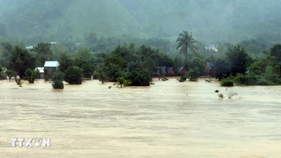
From November 6-7, the area from Da Nang to Dak Lak will have very heavy rain, with rainfall ranging from 200-400mm/period, in some places over 600mm/period; the area from South Quang Tri to Thua Thien Hue, Khanh Hoa and Lam Dong will have heavy rain, with rainfall ranging from 150-300mm/period, in some places over 450mm/period.
From November 7-8, the area from North Quang Tri to Thanh Hoa will have moderate to heavy rain, with average rainfall of 50-150mm/period, and in some places over 200mm/period.
Disaster risk level: Level 4
Applicable to the coastal area from Da Nang to Khanh Hoa (including Ly Son special zone) and the mainland from Quang Ngai to Dak Lak.
The National Center for Hydro-Meteorological Forecasting recommends that localities, units and people proactively monitor the next bulletins, take storm prevention measures, and ensure safety for people and property.
(The next bulletin will be broadcast at 11:00 on November 5, 2025.)
Source: https://quangngaitv.vn/bao-so-13-tren-bien-dong-kha-nang-anh-huong-truc-tiep-den-quang-ngai-dak-lak-6509683.html
![[Photo] Opening of the 14th Conference of the 13th Party Central Committee](https://vphoto.vietnam.vn/thumb/1200x675/vietnam/resource/IMAGE/2025/11/05/1762310995216_a5-bnd-5742-5255-jpg.webp)


![[Photo] Panorama of the Patriotic Emulation Congress of Nhan Dan Newspaper for the period 2025-2030](https://vphoto.vietnam.vn/thumb/1200x675/vietnam/resource/IMAGE/2025/11/04/1762252775462_ndo_br_dhthiduayeuncbaond-6125-jpg.webp)


Comment (0)