

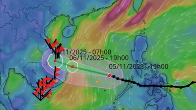
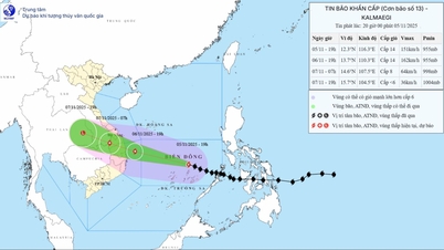
The National Center for Hydro-Meteorological Forecasting said that after entering the East Sea, storm No. 13 will maintain its west-northwest direction at a speed of 20-25km/h until making landfall in the South Central region.
Due to the storm's influence, the sea area east of the central East Sea has winds gradually increasing to level 6-7, then increasing to level 8-10, the area near the storm's center has strong winds of level 11-13, gusting to level 15-16, waves 5-7m high. The sea is very rough.
After that, the sea area off the coast of Da Nang - Khanh Hoa is likely to be affected by strong winds of level 12-14, gusting to level 17, and waves of 8-10m high. The sea will be very rough.
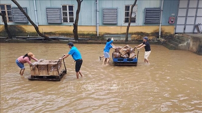
All ships and structures operating in the above-mentioned dangerous areas are strongly affected by storms, whirlwinds, strong winds and big waves.
With the tropical convergence zone active, there will be more rain. In addition, when the storm enters the East Sea, the wide storm circulation will increase the intensity of the southwest monsoon, and the rain will increase even more.
Source: https://quangngaitv.vn/mien-trung-giam-mua-truoc-dot-mua-rat-lon-6509711.html


![[Photo] Opening of the 14th Conference of the 13th Party Central Committee](https://vphoto.vietnam.vn/thumb/1200x675/vietnam/resource/IMAGE/2025/11/05/1762310995216_a5-bnd-5742-5255-jpg.webp)


![[Photo] Panorama of the Patriotic Emulation Congress of Nhan Dan Newspaper for the period 2025-2030](https://vphoto.vietnam.vn/thumb/1200x675/vietnam/resource/IMAGE/2025/11/04/1762252775462_ndo_br_dhthiduayeuncbaond-6125-jpg.webp)


Comment (0)