
The National Center for Hydro-Meteorological Forecasting said that at 4:00 a.m. this morning, November 30, the center of storm No. 15 (storm Koto) was located at about 13.8 degrees north latitude and 112.2 degrees east longitude, in the northwest sea area of the central East Sea.

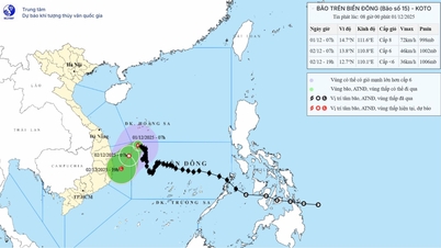
Storm No. 15 changed direction two more times before entering the Central region (PHOTO: VNDMS)
Near the center of the storm, the strongest wind is at level 9, equivalent to a speed of 75 - 88 km/h, gusting to level 11. The storm is moving in a north-northeast direction, at a speed of about 3 km/h. It is forecasted that in the next 24 - 48 hours, storm No. 15 will continue to change direction 2 more times, then head straight for the Central provinces.
Specifically, it is forecasted that by 4:00 a.m. tomorrow, December 1, the center of storm No. 15 will be at about 14.4 degrees north latitude and 112.3 degrees east longitude, located in the northwest sea area of the central East Sea, about 340 km east of Gia Lai - Dak Lak provinces.
At this time, the storm is still at level 9, gusting to level 11, but has changed direction of movement, from northeast to north.
Forecast at 4:00 a.m. on December 2, the storm center is at 13.9 degrees north latitude and 114.0 degrees east longitude, in the northwest sea area of the central East Sea, about 230 km east of the east coast of Gia Lai - Dak Lak provinces and gradually weakening.
It is forecasted that storm No. 15 will be at level 8 intensity, gusting to level 10, moving at a speed of 3 - 5 km/hour, changing direction from north to west southwest, at a speed of 3 - 5 km/hour.
At 4:00 a.m. on December 3, storm No. 15 was still moving west-southwest, increasing its speed from 5-7 km/h, towards Gia Lai - Dak Lak provinces. At this time, the intensity of storm No. 15 continued to weaken, possibly weakening into a tropical depression or low pressure area before moving inland to the Central region.
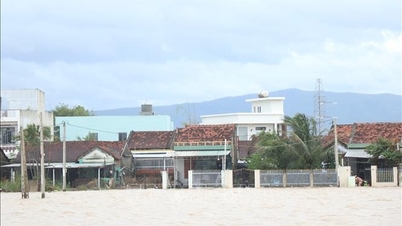
Storm No. 15 causes heavy rain from Hue - Khanh Hoa
The National Center for Hydro-Meteorological Forecasting warns that due to the influence of storm No. 15, the northwest sea area in the central East Sea will have strong winds of level 7. Near the eye of the storm, strong winds of level 8 - 9, gusting to level 11. Waves are 3 - 5 m high, near the eye of the storm, waves are 5 - 7 m high, and the sea is very rough.
Forecast on land from December 2-3, storm No. 15's circulation will cause moderate to heavy rain in the area from Hue City to Khanh Hoa, focusing on the coast, with rainfall in 2 days of about 70-150 mm./.
According to Thanh Nien Newspaper
Source: https://thanhnien.vn/bao-so-15-doi-huong-2-lan-di-thang-vao-mien-trung-gay-mua-lon-185251130072832226.htm
Source: https://baolongan.vn/bao-so-15-doi-huong-2-lan-di-thang-vao-mien-trung-gay-mua-lon-a207487.html


![[Photo] Prime Minister Pham Minh Chinh receives President of Cuba's Latin American News Agency](/_next/image?url=https%3A%2F%2Fvphoto.vietnam.vn%2Fthumb%2F1200x675%2Fvietnam%2Fresource%2FIMAGE%2F2025%2F12%2F01%2F1764569497815_dsc-2890-jpg.webp&w=3840&q=75)


Comment (0)