
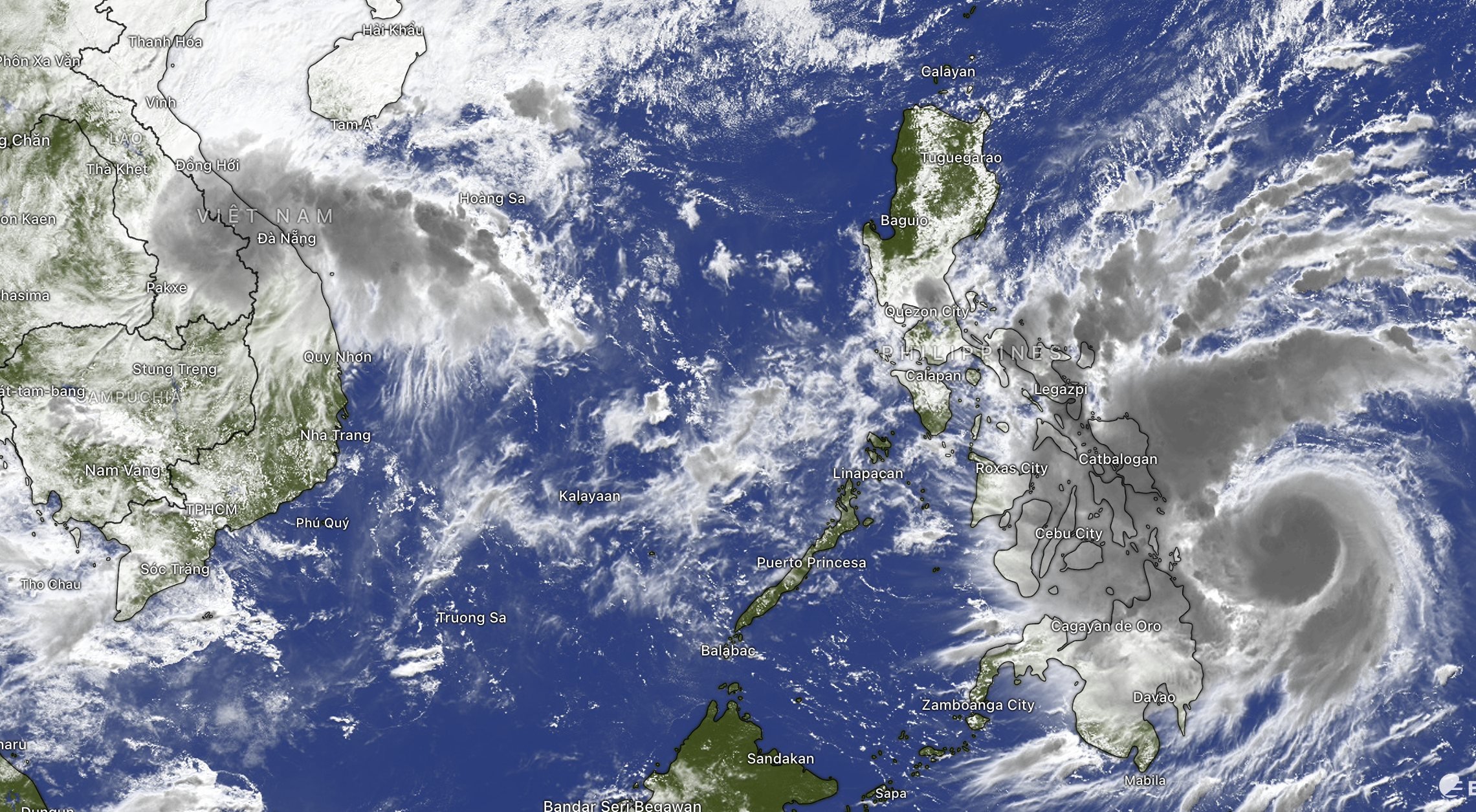
The Southern Hydrometeorological Station said that the Southern region has had moderate rain, heavy rain and thunderstorms in the past 24 hours. The rainfall from 7am yesterday to 7am this morning in Long My - Can Tho was 88.2mm, Dong Ban - Tay Ninh 78.4mm, Thanh Tri - Can Tho 77.4mm, Tay Ninh 73.4mm, Vinh Gia - An Giang 63.8mm...
From 1pm this afternoon to 1pm on November 5, the Southern region will continue to have moderate rain, heavy rain and thunderstorms, with some places experiencing very heavy rain. Total rainfall is generally 70-140mm, with some places experiencing over 140mm.
Rain forecast in provinces and cities as follows: Ho Chi Minh City 70-110mm, Lam Dong, Dong Nai, Vinh Long, Dong Thap 100-150mm, Tay Ninh 70-120mm, Can Tho, An Giang 80-120mm, Ca Mau 90-140mm.
This morning, November 3, many places in Ho Chi Minh City had early rain. Morning rain is not too unusual during days when there is low pressure or tropical convergence zone activity.
Heavy rain continues to occur in the Southern region and Ho Chi Minh City. Total rainfall from 1pm on November 5 to 1pm on November 6 is generally 50-100mm, with some places over 100mm.
Beware of the possibility of heavy rain causing flooding in low-lying areas, urban areas, industrial areas, riverside areas and canals. During thunderstorms there is a possibility of tornadoes, lightning, hail and strong gusts of wind.
At the same time, the high tide in the downstream area of Saigon River also rose rapidly, with peak tide forecast at Phu An station at 1.7-1.71m on November 6, Nha Be station at 1.71-1.75m on November 6, and Thu Dau Mot station at 1.83m on November 6.
Source: https://ttbc-hcm.gov.vn/canh-bao-ngap-nang-tai-tp-hcm-va-nam-bo-do-mua-gian-tiep-tu-bao-va-trieu-cuong-hon-1-8m-1019901.html
![[Photo] Opening of the 14th Conference of the 13th Party Central Committee](https://vphoto.vietnam.vn/thumb/1200x675/vietnam/resource/IMAGE/2025/11/05/1762310995216_a5-bnd-5742-5255-jpg.webp)


![[Photo] Panorama of the Patriotic Emulation Congress of Nhan Dan Newspaper for the period 2025-2030](https://vphoto.vietnam.vn/thumb/1200x675/vietnam/resource/IMAGE/2025/11/04/1762252775462_ndo_br_dhthiduayeuncbaond-6125-jpg.webp)


Comment (0)