
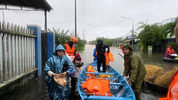
due to deep flooding. Photo: VNA
Due to the influence of cold air strengthening combined with disturbances in the East wind zone, from the night of October 30 to October 31, the Northeastern region will have scattered rain, the provinces from Thanh Hoa to Quang Tri will have moderate rain, heavy rain, locally very heavy rain, common rainfall of 100 - 200 mm, in some places over 350 mm.
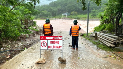
Particularly from Ha Tinh to Da Nang City and the East of Quang Ngai, on the morning of October 30, there was heavy rain, in some places over 80 mm. Warning of the risk of heavy rain over 150 mm/3 hours, with a high risk of flash floods, landslides in mountainous areas and localized flooding in low-lying areas.
In the North, from tonight the temperature will drop significantly, generally 20 - 23 degrees Celsius, in mountainous areas below 20 degrees Celsius. From the night of November 1, the weather will be cold, in mountainous areas of the North it will be cold, the lowest temperature is generally 19 - 22 degrees Celsius, in mountainous areas below 17 degrees Celsius. In the capital Hanoi, from October 30 to November 1, there will be rain, from the night of November 1, the weather will turn cold, the lowest temperature is 20 - 22 degrees Celsius.
On land, strong northeast winds at level 2-3, coastal areas at level 3-4. At sea, from the night of October 30, the northeast winds in the Gulf of Tonkin gradually increase to level 5, sometimes level 6, gusts at level 7-8, rough seas, waves 1.5-2.5 m high; the northern part of the East Sea has strong winds at level 6, gusts at level 7-8, waves 2-4 m high.
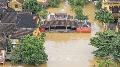
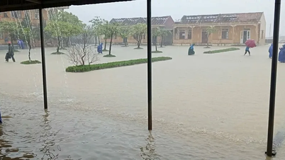
Heavy rains in recent days have caused the water levels of rivers in the Central region to rise. Currently, the flood on the Thu Bon River (Quang Nam) is fluctuating at a high level and above alert level 3 from 1.6 - 1.7 m, higher than the historical flood level in 1964. The flood on the Huong River, Vu Gia River and Tra Khuc River is decreasing but is still above alert levels 2 - 3. It is forecasted that in the next 24 hours, the flood will continue to remain at a high level; deep and widespread flooding from Hue to Quang Ngai may last for a few more days.
Meteorological experts warn that people in mountainous areas need to proactively prevent the risk of flash floods and landslides; low-lying localities need to have plans to respond to floods, ensuring safety for people, especially in areas that are isolated by floods.
Source: https://baohaiphong.vn/khong-khi-lanh-tran-xuong-bac-bo-chuyen-lanh-trung-bo-mua-rat-to-525037.html

![[Photo] General Secretary To Lam attends the Vietnam-UK High-Level Economic Conference](https://vphoto.vietnam.vn/thumb/1200x675/vietnam/resource/IMAGE/2025/10/30/1761825773922_anh-1-3371-jpg.webp)
![[Photo] Touching scene of thousands of people saving the embankment from the raging water](https://vphoto.vietnam.vn/thumb/1200x675/vietnam/resource/IMAGE/2025/10/30/1761825173837_ndo_br_ho-de-3-jpg.webp)
![[Photo] General Secretary To Lam meets former British Prime Minister Tony Blair](https://vphoto.vietnam.vn/thumb/1200x675/vietnam/resource/IMAGE/2025/10/30/1761821573624_tbt-tl1-jpg.webp)
![[Photo] National Assembly Chairman Tran Thanh Man receives foreign ambassadors who came to say goodbye](https://vphoto.vietnam.vn/thumb/1200x675/vietnam/resource/IMAGE/2025/10/30/1761820977744_ndo_br_1-jpg.webp)


![[Photo] Standing member of the Secretariat Tran Cam Tu visits and encourages people in the flooded areas of Da Nang](https://vphoto.vietnam.vn/thumb/1200x675/vietnam/resource/IMAGE/2025/10/30/1761808671991_bt4-jpg.webp)


Comment (0)