
According to the meteorological agency, during the day and night of November 22, the provinces from the East of Quang Ngai to Dak Lak and the North of Khanh Hoa will have moderate rain, heavy rain, and locally very heavy rain of 30-60 mm, with some places exceeding 120 mm. On the day and night of November 23, the rain will spread to Hue City and the East of Da Nang - Gia Lai, with common rainfall of 30-70 mm, and some places may exceed 120-130 mm.
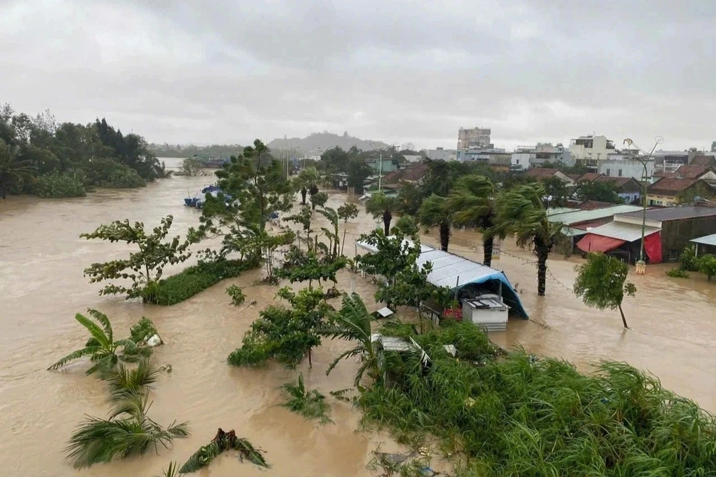
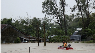
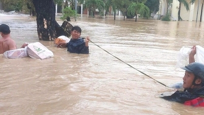
Prolonged heavy rains have caused flooding in many rivers and streams in the Central Highlands and South Central Coast. Currently, water levels on the Krong Ana River, Dong Nai River, Ba River (Dak Lak) and Dinh Ninh Hoa River (Khanh Hoa) are falling.
It is forecasted that in the next 12 hours, flood on Krong Ana River will continue to decrease but still be above alert level 3; flood on Dong Nai River will slowly decrease and remain above alert level 2. In the next 12-24 hours, the decreasing trend will continue on both rivers.
In the next 24 hours, the flood on Dinh Ninh Hoa River will continue to decrease and fluctuate from alert level 2 to alert level 3; the flood downstream of Ba River at Phu Lam station will remain below alert level 1; only Srepok River (Dak Lak) at Ban Don station will still fluctuate above alert level 3. Flooding will continue in many areas from Dak Lak to Khanh Hoa. There is a very high risk of flash floods on small rivers and streams and landslides in steep hilly areas.
At sea, strong winds remain in many areas. In the North East Sea, there are strong northeast winds of level 7, gusts 8-9; in Ly Son, winds of level 6-7, gusts 8; in Huyen Tran area, gusts 8; in Phu Quy, gusts 7. It is forecasted that during the day and night of November 22, the North East Sea (including Hoang Sa sea area) will have strong northeast winds of level 6-7, gusts 8-9, waves 4-6 m high, rough seas.
The sea strip from South Quang Tri to Quang Ngai and the North Central East Sea has strong winds of level 6, sometimes level 7, gusts 8-9; waves 4-6m high; rough seas. The sea area from Gia Lai to Ho Chi Minh City has northeast winds of level 6, gusts 7-8; waves 3-5m high; rough seas. Meanwhile, the sea area from Dong Thap to Ca Mau has winds of level 5, sometimes level 6, gusts 7, waves 2-4m, rough seas.
The Meteorological Agency warns that the central and southern East Sea, the sea area from South Quang Tri to Ca Mau, Ca Mau to An Giang and the southern Gulf of Thailand will have showers and thunderstorms; there is a risk of tornadoes and gusts of wind of level 6-7. People and vessels operating at sea need to closely monitor weather developments to proactively respond.
Weather forecast for regions across the country:
Hanoi capital is cloudy, sunny during the day, no rain at night. Northeast wind level 2-3. Cold in the morning and at night. Lowest temperature 15-17 degrees Celsius. Highest temperature 24-26 degrees Celsius.
The Northwestern provinces are cloudy, sunny during the day, no rain at night. Light wind. Cold in the morning and at night, some places are very cold. Lowest temperature 12-15 degrees Celsius, some places below 11 degrees Celsius. Highest temperature 23-26 degrees Celsius.
The Northeast region is cloudy, no rain at night, sunny during the day. Northeast wind level 2-3. Cold in the morning and at night, some mountainous areas are very cold. Lowest temperature 15-18 degrees Celsius, some places below 14 degrees Celsius. Highest temperature 23-26 degrees Celsius.
Provinces from Thanh Hoa to Hue have cloudy weather, sunny days, and some rain at night; Hue City is cloudy with scattered showers and thunderstorms, with heavy rain in some places. North to northwest wind level 2-3, coastal areas level 3-4. In the north, the morning and night are cold. During thunderstorms, there is a possibility of tornadoes, lightning, and strong gusts of wind. Lowest temperature 16-19 degrees Celsius. Highest temperature 22-25 degrees Celsius.
The South Central Coast region is cloudy with moderate to heavy rain, locally very heavy rain and thunderstorms; in the East of Da Nang City and Lam Dong, there are scattered showers and thunderstorms, locally heavy rain. Northeast to north wind level 2-3, coastal areas level 3-4, some places gust level 6. During thunderstorms, there is a possibility of tornadoes, lightning and strong gusts. The lowest temperature in the North is 19-22 degrees Celsius, in the South is 22-25 degrees Celsius. The highest temperature in the North is 23-26 degrees Celsius, in the South is 26-29 degrees Celsius.
The Central Highlands is cloudy with scattered showers and thunderstorms, with heavy rain in some places. Northeast wind level 3. There is a possibility of tornadoes, lightning and strong gusts of wind in thunderstorms. Lowest temperature 17-20 degrees Celsius. Highest temperature 23-26 degrees Celsius, some places above 26 degrees Celsius.
The South is cloudy with scattered showers and thunderstorms. Northeast wind level 2-3. There is a possibility of tornadoes, lightning and strong gusts of wind during thunderstorms. Lowest temperature 23-26 degrees Celsius. Highest temperature 28-31 degrees Celsius.
Ho Chi Minh City is cloudy with scattered showers and thunderstorms; in the late afternoon and evening, there may be showers and thunderstorms. Northeast wind level 2-3. There is a possibility of tornadoes and lightning during thunderstorms. Lowest temperature 23-25 degrees Celsius. Highest temperature 29-31 degrees Celsius.
Source: https://baohaiphong.vn/mien-bac-ret-keo-dai-trung-trung-bo-va-tay-nguyen-tiep-tuc-mua-527418.html
![[Photo] General Secretary To Lam receives President of the Senate of the Czech Republic Milos Vystrcil](/_next/image?url=https%3A%2F%2Fvphoto.vietnam.vn%2Fthumb%2F1200x675%2Fvietnam%2Fresource%2FIMAGE%2F2025%2F11%2F21%2F1763723946294_ndo_br_1-8401-jpg.webp&w=3840&q=75)


![[Photo] Visit Hung Yen to admire the "wooden masterpiece" pagoda in the heart of the Northern Delta](/_next/image?url=https%3A%2F%2Fvphoto.vietnam.vn%2Fthumb%2F1200x675%2Fvietnam%2Fresource%2FIMAGE%2F2025%2F11%2F21%2F1763716446000_a1-bnd-8471-1769-jpg.webp&w=3840&q=75)

![[Photo] President Luong Cuong receives Speaker of the Korean National Assembly Woo Won Shik](/_next/image?url=https%3A%2F%2Fvphoto.vietnam.vn%2Fthumb%2F1200x675%2Fvietnam%2Fresource%2FIMAGE%2F2025%2F11%2F21%2F1763720046458_ndo_br_1-jpg.webp&w=3840&q=75)


Comment (0)