
Mr. Nguyen Hong Truong, Director of Khanh Hoa Province Hydrometeorological Station, said: The center of storm No. 13 (Kalmaegi) at 3 p.m. is at about 13.4 degrees North latitude; 110.2 degrees East longitude, about 120km east-southeast of Quy Nhon ( Gia Lai ). This storm is carrying the strongest wind up to level 14 (150-166km/h), gusting to level 17, posing a huge threat to the mainland. It is forecasted that in the next 3 hours, the storm will move mainly in the west-northwest direction, at a fast speed of about 30km/h.

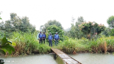
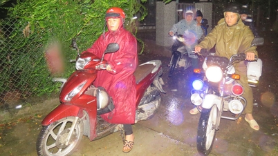
The authorities of Nam Nha Trang ward went door to door to encourage people in the mountain village to move to a safe place to avoid the risk of landslides. Photo: Kim So.
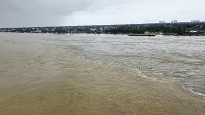
According to Mr. Truong, due to the influence of storm Kalmaegi, the rain situation in Khanh Hoa province is forecast to be very complicated from this afternoon to the end of the morning of November 7. The recorded rainfall at 3 p.m. is generally from 30 to 60mm; Dai Lanh 94.2mm; Van Binh 66.2mm, Hoa Son lake 103.4mm. The southern part of the province has rain from 20-40mm.
“From this afternoon until the morning of November 7, the whole Khanh Hoa province will have moderate rain, heavy rain and thunderstorms, and very heavy rain in some places. The rain will be concentrated tonight and early morning of November 7,” Mr. Truong shared.
The total rainfall forecast in the western and northern areas of the province is generally from 80 - 200 mm, especially in some places the rainfall may exceed 250 mm. The southern area of the province reaches from 70 - 120 mm. During thunderstorms, the risk of tornadoes, lightning and strong gusts of wind is very high. The western and northern areas of the province are warned of the risk of rain with intensity greater than 80 mm/3 hours.
In this situation, Mr. Truong also warned that a flood would occur due to hydrological conditions. Rivers and streams in the north of the province are at risk of reaching alert level 2-3, while rivers and streams in the south of the province are at alert level 1-2. Particularly, the southern edge of storm No. 13 will cause strong winds in coastal communes including: Dai Lanh, Tu Bong, eastern Ninh Hoa, northern Nha Trang.

Mountain villagers gather their belongings and move to safety. Photo: Kim So.
The risk of flash floods and landslides is warned in: Van Hung, Van Thang, Dai Lanh, west Ninh Hoa, east Ninh Hoa, Nha Trang (and the West, North, South areas), Suoi Hiep, Cam Lam, Cam An, Suoi Dau, Cam Hiep, South Cam Ranh, the entire area of Khanh Vinh, Khanh Son, and neighboring communes such as Bac Ai, Ninh Son, My Son, Phuoc Dinh, Ca Na, Cong Hai, Thuan Bac, Vinh Hai.
The risk of flooding is concentrated in communes and wards such as: Ninh Hoa, Tan Dinh, Hoa Thang, Nam Ninh Hoa, Dien Khanh, Dien Dien, Dien Lac, communes/wards in Nha Trang area (north, west, south), Cam Ranh, Nam Cam Ranh, Ba Ngoi, Phan Rang, Bao An, Ninh Chu, Dong Hai, Ninh Hai, Ninh Phuoc, Thuan Nam.
Source: https://nongnghiepmoitruong.vn/nhieu-dia-phuong-tinh-khanh-hoa-canh-bao-nguy-co-lu-quet-sat-lo-dat-d782735.html


![[Photo] Closing of the 14th Conference of the 13th Party Central Committee](https://vphoto.vietnam.vn/thumb/1200x675/vietnam/resource/IMAGE/2025/11/06/1762404919012_a1-bnd-5975-5183-jpg.webp)

![[Photo] Prime Minister Pham Minh Chinh receives the delegation of the Semiconductor Manufacturing International (SEMI)](https://vphoto.vietnam.vn/thumb/1200x675/vietnam/resource/IMAGE/2025/11/06/1762434628831_dsc-0219-jpg.webp)


![Building a 'fortress' against natural disasters: [Part 2] Changing state from passive to active](https://vphoto.vietnam.vn/thumb/402x226/vietnam/resource/IMAGE/2025/11/06/1762423529917_0242-2223-160125_902.jpeg)


Comment (0)