
Storm No. 3 increased in intensity very quickly, in just 24 hours, the storm's intensity increased by 8 levels and maintained super storm level for a long time. When it made landfall on Hainan Island (China), it still maintained super storm intensity.
Storm No. 3 (Storm Yagi ) and its circulation caused severe damage to many provinces in the northern delta and mountainous areas.
According to Director of the National Center for Hydro-Meteorological Forecasting Mai Van Khiem, storm No. 3 is the strongest storm in the past 30 years in the East Sea region.
Storm No. 3 is also a storm that increases in intensity very quickly, in just 24 hours the storm's intensity increased by 8 levels and maintained super storm level for a long time. When it landed in the East of Hainan Island (China), it still maintained the intensity of a super storm.
Notably, the rate of deterioration along the storm's path does not follow a regular pattern.
The storm forced Hai Phong, Quang Ninh and Thai Binh cities to issue a level 4 disaster risk warning, which is close to a disaster level.
Yen Bai and Lao Cai provinces must warn of natural disaster risk at level 3 for flash floods and landslides, which is the highest level.
Specifically, normally when passing Hainan Island (China) into the Gulf of Tonkin, storms often weaken quickly, but with storm No. 3, the intensity did not decrease quickly, when approaching the coast of Quang Ninh-Hai Phong, it still maintained the intensity of level 12-13. In addition, the time the storm stayed on land was long (12 hours).
Storm No. 3 moved deep inland and weakened into a tropical depression in the Northwest region.
")
However, the heaviest rains caused by storm No. 3 were mainly in the East of Hoang Lien Son mountain range, although they were not in the storm's path and were not directly affected by the storm's winds. Most storms with similar trajectories in the past often caused heavy rains in the West of Hoang Lien Son mountain range.
Very heavy rain over a large area (including many provinces) in the basins of Thao, Chay, Lo, and Gam rivers with high intensity (over 200 mm/day), lasting for many days after the storm dissipated; in which, there were areas with rainfall of over 200 mm within just 2 hours.
“In the online discussion sessions between the staff of the National Center for Hydro-Meteorological Forecasting and international experts from the Regional Typhoon Forecasting Center of Japan and the China Meteorological Agency, they all agreed on the unusual characteristics of storm No. 3 and the heavy rain caused by the storm circulation in the Gulf of Tonkin, the Northern Midlands and Mountains and the Southern region of China,” the Director of the National Center for Hydro-Meteorological Forecasting shared.
Numbers on historical flood peaks
Regarding floods, according to the Director of the National Center for Hydro-Meteorological Forecasting, due to heavy rains, since September 8, water levels on many rivers and streams in the North have risen rapidly. In particular, water levels on Thao River, Lo River, Thuong River, Gam River, Thai Binh River, the lower reaches of the Red River, Luc Nam River, Hoang Long River... have all exceeded alert level 3, some rivers have exceeded alert level 3 by 3-4m.
“In particular, the flood on Thao River in Lao Cai and Yen Bai has exceeded the historical flood peak that existed for 53 years. The flood peak in Yen Bai reached 35.73m at 4 p.m. on September 10, 3.73m above the alarm level 3 and 1.31m above the historical flood level in 1968. The peak water level at Lao Cai station was 86.97m, 3.47m above the alarm level 3; at Bao Ha it was 61.95m, 4.95m above the alarm level 3, 1.02m above the historical flood level in 2008 (60.93m); at Yen Bai it reached its peak at 35.73m, 3.73m above the alarm level 3, 1.31m above the historical flood level in 1968,” Mr. Mai Van Khiem informed.
In Hanoi, the water level of the Red River also recorded its highest level in 20 years.
")
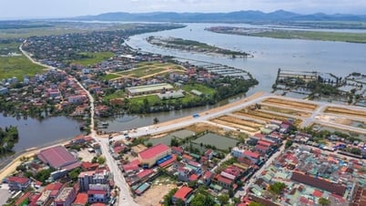
Rivers in the Red and Thai Binh river basins - the largest river system in the North - have experienced floods and inundation on a large scale with many levels exceeding the threshold, which is also rare.
According to statistics, 20/25 northern provinces and cities experienced serious flooding.
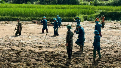
Regarding flash floods and landslides: due to heavy rains, landslides and flash floods have occurred in many localities, causing very heavy damage to people and property. Some areas have experienced serious flash floods and landslides, such as in the provinces of Cao Bang, Hoa Binh, Lao Cai, Yen Bai, Quang Ninh, etc.
In particular, in Lang Nu village, Phuc Khanh commune, Bao Yen district, Lao Cai province, landslides caused particularly serious human damage.
The main reason is that the northern mountainous region has had a lot of rain in the past 3 months, 40-60% higher than the average of many years.
In Lao Cai in August there were 23/31 rainy days and in Yen Bai 21/31 rainy days, which is also rare.
In most areas, the soil is saturated with water, so when there is a very heavy rain that lasts for many days with high intensity like recently, landslides have occurred in many places.
Lao Cai experienced flash floods and large-scale landslides. Yen Bai experienced smaller-scale landslides but they occurred in many places (in Yen Bai city alone, over 1,000 landslides were recorded).
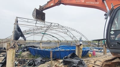
According to a quick report from the Department of Dyke Management and Natural Disaster Prevention and Control (Ministry of Agriculture and Rural Development), as of 5:00 p.m. on September 16, the number of dead and missing people due to storm No. 3 and floods in the northern provinces reached 329 (291 dead, 38 missing); 1,922 injured.
Total economic damage is estimated at over 32,787 billion VND.
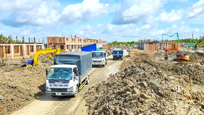
On September 15, chairing the Government Standing Committee meeting with localities affected by storm No. 3, Prime Minister Pham Minh Chinh requested that, in the spirit of "all for the people, for the development of the country," ministries, branches and localities urgently overcome the consequences of storms and floods, quickly stabilize people's lives, restore production and business activities, and promote economic growth. Prime Minister Pham Minh Chinh pointed out that branches and localities continue to count the damage of the state and people; organize temporary and safe accommodation for people who have lost their homes; at the same time, organize resettlement for all people who have lost their homes or been buried to safe places, to be completed before December 31, 2024 with safer and better conditions than their old places; organize traffic restoration; ensure social security, not leaving anyone behind; count the damage to have policies to support affected families, and reduce tuition fees for students affected by storms and floods.
Regarding production and business, the Prime Minister requested to review and count the damage to restore cultivation, livestock, and service business; especially credit policies, support for seedlings and fertilizers for agriculture, support for the restoration of services, and industrial production, to avoid disruption of supply chains and production chains. Along with that, there are plans to strengthen transportation, reduce transportation fares, restore warehouses for goods gathering; and regulate hydroelectric and irrigation works in flood discharge and water storage.
Vietnamplus.vn
Source: https://www.vietnamplus.vn/nhung-diem-bat-thuong-cua-bao-yagi-con-bao-manh-nhat-30-nam-qua-post977216.vnp


![[Photo] President Luong Cuong receives US Secretary of War Pete Hegseth](https://vphoto.vietnam.vn/thumb/1200x675/vietnam/resource/IMAGE/2025/11/02/1762089839868_ndo_br_1-jpg.webp)

![[Photo] Lam Dong: Images of damage after a suspected lake burst in Tuy Phong](https://vphoto.vietnam.vn/thumb/1200x675/vietnam/resource/IMAGE/2025/11/02/1762078736805_8e7f5424f473782d2162-5118-jpg.webp)


Comment (0)