
In order to concretize the overall development plan of Tam Chuc National Tourist Area to 2030, the general urban plan of Kim Bang, the regional plan of Ha Nam province; exploit the potential, advantages of location, natural landscape values combined with conservation and embellishment of natural ecosystems in the area; create momentum for sustainable socio -economic development,... recently, the Provincial People's Committee has issued decisions approving the tasks of zoning construction planning at a scale of 1/2000 for functional areas of Tam Chuc National Tourist Area.
Planning of functional areas
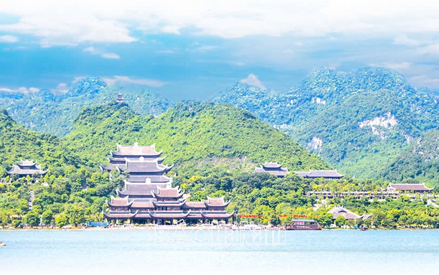
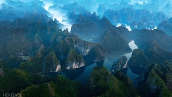
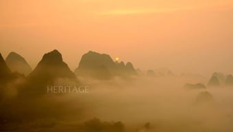
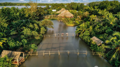
The first functional area is the Spiritual Cultural Area of Tam Chuc National Tourist Area with a planning study area of about 1,213 hectares. Of which, 1,005 hectares is the Tam Chuc Spiritual Cultural Area (according to Decision No. 526/QD-TTg, dated May 15, 2018 of the Prime Minister approving the Master Plan for the development of Tam Chuc National Tourist Area, Ha Nam Province to 2030) and 208 hectares is the additional area to the planning study area belonging to the combined interspersed land between Ha Nam and Hanoi, Hoa Binh as a natural mountainous landscape conservation area. Forming a large-scale spiritual cultural center in the Capital region, the Red River Delta region in general and Ha Nam in particular, associated with the main functions: Visiting, making pilgrimages, practicing beliefs, worshiping religious works, organizing short-term courses on Buddhism; Preserve and maintain traditional culture of the Red River Delta and Northeastern coastal regions; organize synchronous cultural, artistic, sports and entertainment events.
The logistics service center area serves tourism activities in Tam Chuc National Tourist Area. This is a place to provide resort tourism services, entertainment tourism, adventure tourism, shopping tourism, culinary tourism, etc. associated with urban development, combined with renovation and embellishment of existing residential areas, ensuring synchronous social infrastructure and technical infrastructure systems to serve the needs of people in the area and the activities of the National Monument of Tam Chuc Scenic Landscape Complex - Tam Chuc National Tourist Area. Forming a functional area with the role of a logistics service center providing tourism services on the basis of investing in a new urban area associated with upgrading, renovating and embellishing the existing urban area, ensuring harmony between the old area and the newly built area, serving the activities of Tam Chuc National Tourist Area. The scale of the planning research area is about 502 hectares. The expected population size is about 15,000 people; of which, the current population is about 6,000 people.
The resort, health care and community tourism area of Tam Chuc National Tourist Area has a planning study area of about 605 hectares. It is expected to serve about 10.2 to 16.7 million visitors/day (according to Decision No. 526/QD-TTg, dated May 15, 2018 of the Prime Minister), not including the number of service personnel. The permanent population is about 3,500 people; of which, the current population is about 2,500 people, the newly developed and developing population is about 1,000 people. Forming a medical examination and treatment center for the elderly combined with tourism, health care resorts, and community tourism. This is one of the regional health care, resort and community tourism (homestay) centers; is a center for accommodation services, commercial services associated with the preservation and restoration of old residential areas and has synchronous technical infrastructure and social infrastructure works.
The reception center of Tam Chuc National Tourist Area has a planning research area of about 168 hectares. Serving about 10.2 to 16.7 million visitors/day (also according to Decision No. 526/QD-TTg, dated May 15, 2018 of the Prime Minister) and not including the number of service staff. The nature is a place to welcome, coordinate activities, provide information, guide tourists and is a center for organizing large-scale, modern, and synchronous conferences, seminars, exhibitions, and product introductions of Tam Chuc National Tourist Area.
Kim Bang Golf Course and Ba Hang Lake have a planning study area of about 859 hectares. Here, resorts, entertainment, sports (golf, mountain climbing, ...) with synchronous facilities are formed on the basis of maximizing the advantages of terrain and natural landscape of the area. Determining the protection zone, embellishing the rare natural flora and fauna habitats in the area and surrounding areas, becoming an endemic buffer zone, a green lung for the entire region. It is the legal basis for implementing detailed planning projects 1/500, managing construction investment projects, managing the construction and development process. At the same time, this is also one of the resort centers combining entertainment, sports with synchronous, high-class facilities at the regional level; it is an area with preserved and embellished natural landscapes. During the project research process, when there are new elements that play a role in increasing the value of the architectural landscape space, serving the community and promoting socio-economic development, it is possible to consider proposing adjustments and additions to the properties accordingly.
Requirements on planning research content
In the decisions approving the 1/2000 scale construction zoning planning tasks of the functional areas of Tam Chuc National Tourist Area, the Provincial People's Committee requested the Ha Nam Department of Construction - the investor and the planning agency (a consulting unit with suitable capacity, selected according to current legal regulations) when developing the planning project to assess the natural conditions, current status of landscape architecture, technical infrastructure and environment. In particular, assessing the natural characteristics of the study area (in terms of terrain, geomorphology, climate, hydrology, irrigation, engineering geology, etc.), the ecological landscape characteristics of the area in connection with adjacent surrounding areas; assessing the situation of land use, architectural works, housing in the planning area (agricultural, forestry areas, existing residential areas, religious works, cultural history that need to be protected, national defense and security, etc.). In particular, it is necessary to clearly determine the land area, area scale, and height of existing religious buildings in the research area.
In addition, it is also necessary to assess the current status of tourism development in the research area, population and labor statistics; assess the development history, socio-culture in the area, the impacts on the cultural environment, history, economic development process, culture and life of the residents in the area... then, synthesize the current issues, make an analysis of strengths, weaknesses, opportunities, challenges in the research and development area, comprehensively propose issues that need to be solved and advantages that need to be exploited as a basis for the planning scheme. At the same time, there must be forecasts of population, labor, and tourists as a basis for assessing the demand for land use scale on the basis of economical and effective exploitation of land resources, natural landscape values, improving the efficiency of infrastructure use and meeting the needs of long-term development reserves; select land use indicators suitable to the nature and function of each area; Forecasting the scale of public works, technical infrastructure, social infrastructure... is the driving force for socio-economic development of the area; selecting economic and technical indicators suitable to the nature and function of the planning area, as a basis for forecasting the scale of development of functional works...
On the basis of the master plan, the general plan has been established, inheriting and linking the projects that have been and are being implemented within the planning scope and adjacent to the architectural space as well as the technical infrastructure, forming a complex of modern architectural works with rich identity. In which, ensuring the overallity and development capacity of the unified planning structure, creating a tourist area space of national and international scale; ensuring the rationality of the spatial organization of functional areas, as well as the sustainability of the environment and natural landscape. The architectural planning space must meet the requirements of spatial organization, environment, and have its own identity.
Organizing the space of functional areas according to the characteristics of each project with solutions to limit construction density, architectural blocks suitable for use, harmonious in color, local climate, energy saving; forming open spaces with favorable viewpoints to exploit the value of landscape architectural space. Focusing on green space, water surface combined with the scale of blocks and architectural forms of the project. Organizing and arranging functional works according to the principle of organizing a hierarchical network, according to hierarchy, ensuring accessibility for visitors, convenient service radius and enhancing public utilities.
Identify and forecast environmental impacts caused by planning schemes and socio-economic development activities. Determine measures to prevent and minimize impacts and manage and monitor the environment to ensure sustainable development. The planning of functional areas must comply with conservation, respect for ecosystems, natural flora and fauna and promote the integrity of the ecosystem according to conservation planning projects in the area.
Chu Binh
Source: https://baohanam.com.vn/du-lich/quy-hoach-khu-du-lich-tam-chuc-huong-toi-la-khu-du-lich-quoc-gia-146620.html

![[Photo] Prime Minister Pham Minh Chinh receives a bipartisan delegation of US House of Representatives](https://vphoto.vietnam.vn/thumb/1200x675/vietnam/resource/IMAGE/2025/5/28/468e61546b664d3f98dc75f6a3c2c880)
![[Photo] General Secretary To Lam works with the Central Policy and Strategy Committee](https://vphoto.vietnam.vn/thumb/1200x675/vietnam/resource/IMAGE/2025/5/28/7b31a656d8a148d4b7e7ca66463a6894)
![[Photo] 12th grade students say goodbye at the closing ceremony, preparing to embark on a new journey](https://vphoto.vietnam.vn/thumb/1200x675/vietnam/resource/IMAGE/2025/5/28/42ac3d300d214e7b8db4a03feeed3f6a)
![[Photo] Vietnamese and Hungarian leaders attend the opening of the exhibition by photographer Bozoky Dezso](https://vphoto.vietnam.vn/thumb/1200x675/vietnam/resource/IMAGE/2025/5/28/b478be84f13042aebc74e077c4756e4b)


Comment (0)