
Currently (November 17), the strong cold air mass is continuing to move south.
It is forecasted that around the afternoon and night of November 17, this cold air mass will affect the Northeast and North Central regions, then affect the Northwest, Central Central regions and some places in the South Central region. On land, strong Northeast winds will be level 3-4, coastal areas will be level 4-5, some places will be level 6.
From the afternoon and night of November 17-18, in the Northern region there will be rain, showers and thunderstorms in some places.
From the evening and night of November 17, in the midlands, deltas of the North and North Central regions, the weather will turn cold. In the mountainous areas of the North, it will be very cold, and in some places in the high mountains it will be extremely cold.
The lowest temperature in this cold air mass in the midlands, Northern Delta and North Central regions is generally from 12-15 degrees Celsius, in mountainous areas from 9-12 degrees Celsius, in high mountainous areas in some places below 8 degrees Celsius.
Hanoi area from afternoon and night of November 17-18 will have rain, showers, from evening and night of November 17 the weather will turn cold. The lowest temperature in this cold air mass is commonly 13-15 degrees Celsius.
At sea from the evening and night of November 17, in the Gulf of Tonkin, the Northeast wind gradually increases to level 7, sometimes level 8, gusts to level 9, rough seas, waves 3.0-5.0m high; in the North East Sea, the Northeast wind gradually increases to level 7-8, gusts to level 9-10, rough seas, waves 4.0-6.0m high; from early morning of November 18, in the area from Quang Tri to Quang Ngai and the sea area north of the Central East Sea, the Northeast wind gradually increases to level 6, sometimes level 7, gusts to level 8-9, rough seas, waves 4.0-6.0m high. From November 18, in the sea area from Gia Lai to Khanh Hoa, the Northeast wind gradually increases to level 6, gusts to level 7-8, rough seas, waves 3.0-5.0m high, rough seas.
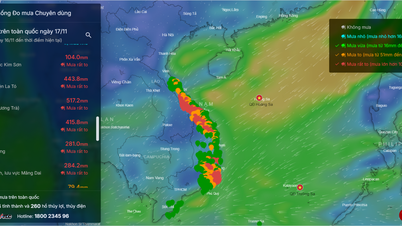
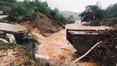
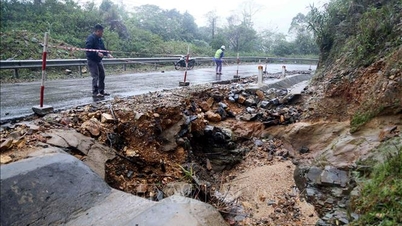
Due to the influence of cold air combined with disturbances in the upper easterly wind zone, there is widespread heavy rain in the area from Ha Tinh to Khanh Hoa.
Accordingly, from early morning of November 17 to night of November 18, the area from Quang Tri to Da Nang city, the east of Quang Ngai and Gia Lai provinces will have heavy to very heavy rain with common rainfall from 200-450mm, locally over 700mm.
Ha Tinh area, eastern Dak Lak province, Khanh Hoa has heavy rain, locally very heavy rain with common rainfall of 100-300mm, locally over 400mm.
In the West of the provinces from Quang Ngai to Dak Lak, Lam Dong area has moderate rain, heavy rain with common rainfall from 50-100mm, locally very heavy rain over 200mm.
Warning of risk of heavy rain (>200mm/3h).
In addition, on the day and night of November 17, the Southern region will have moderate rain and thunderstorms, locally heavy to very heavy rain with common rainfall from 20-40mm, locally over 80mm.
Thunderstorms may contain tornadoes, lightning, hail and strong winds.
Warning, on the day and night of November 19, in Hue City, Da Nang City, the eastern part of Quang Ngai to Dak Lak and Khanh Hoa provinces, there will be heavy to very heavy rain with average rainfall of 70-150mm, locally over 250mm; in Quang Tri area, the western part of Quang Ngai to Dak Lak provinces, there will be moderate to heavy rain with average rainfall of 20-50mm, locally over 100mm.
From November 20, widespread heavy rain continued to occur in Da Nang city and provinces from Quang Ngai to Khanh Hoa; from November 22, heavy rain tended to decrease.
Weather forecast for day and night November 17:
Hanoi City
Lowest temperature: 14-16 degrees Celsius.
Highest temperature: 26-28 degrees Celsius.
Cloudy, no rain, sunny in the afternoon, rain, showers and thunderstorms in the afternoon and at night. Northeast wind level 2-3. Cold at night and morning.
Northwest
Lowest temperature: 12-15 degrees Celsius, some places below 12 degrees Celsius.
Highest temperature: 25-28 degrees Celsius.
Cloudy, rain in some places, from afternoon and night there will be rain, showers and thunderstorms in some places. Light wind. Cold at night, freezing in some places.
Northeast
Lowest temperature: 13-16 degrees Celsius, mountainous areas 11-13 degrees Celsius, high mountainous areas in some places below 19 degrees Celsius.
Highest temperature: 25-28 degrees Celsius.
Cloudy, rain in some places, from afternoon and night there will be rain, showers and thunderstorms in some places. Northeast wind level 3-4, coastal areas level 4-5. Cold in the morning, from evening and night the weather will turn cold, mountainous areas will be very cold, high mountains will have some places with severe cold.
Thanh Hoa - Hue
Lowest temperature: North 13-16 degrees Celsius; South 19-22 degrees Celsius.
Highest temperature: 23-26 degrees Celsius.
Cloudy, in the North (Thanh Hoa - Nghe An) there will be rain in some places, from the evening and at night there will be rain, showers and thunderstorms in some places, in Nghe An in some places there will be moderate to heavy rain; in the South there will be heavy to very heavy rain and thunderstorms. North to Northwest wind level 3-4, coastal areas level 4-5. In the North it will be cold in the morning; from the evening and at night it will turn cold. In thunderstorms there is a possibility of tornadoes, lightning and strong gusts of wind.
South Central Coast
Lowest temperature: 22-25 degrees Celsius.
Highest temperature: North 25-27 degrees Celsius, South 28-30 degrees Celsius.
Cloudy, heavy to very heavy rain and thunderstorms in the North; moderate rain and thunderstorms in the South, locally heavy to very heavy rain. Northeast wind level 2-3. Thunderstorms may cause tornadoes, lightning and strong gusts of wind.
Central Highlands
Lowest temperature: 18-21 degrees Celsius.
Highest temperature: 25-28 degrees Celsius, some places above 28 degrees Celsius.
Cloudy, moderate rain, heavy rain and thunderstorms in the North, locally very heavy rain; moderate rain and thunderstorms in the South, locally heavy to very heavy rain. Northeast wind level 2-3. Thunderstorms may cause tornadoes, lightning and strong gusts of wind.
Southern Vietnam
Lowest temperature: 22-25 degrees Celsius, some places below 21 degrees Celsius.
Highest temperature: 28-31 degrees Celsius.
Cloudy with moderate rain and thunderstorms, locally heavy to very heavy rain. Northeast wind level 2-3. Thunderstorms may cause tornadoes, lightning and strong gusts of wind.
Ho Chi Minh City
Lowest temperature: 23-26 degrees Celsius.
Highest temperature: 29-32 degrees Celsius.
Cloudy with moderate rain and thunderstorms, locally heavy to very heavy rain. Northeast wind level 2-3. Thunderstorms may cause tornadoes, lightning and strong gusts of wind.
Source: https://baophapluat.vn/thoi-weather-ngay-17-11-tu-dem-nay-mien-bac-chuyen-mua-ret.html

![[Photo] General Secretary To Lam and National Assembly Chairman Tran Thanh Man attend the 80th Anniversary of the Traditional Day of the Vietnamese Inspection Sector](https://vphoto.vietnam.vn/thumb/1200x675/vietnam/resource/IMAGE/2025/11/17/1763356362984_a2-bnd-7940-3561-jpg.webp)


Comment (0)