
 |
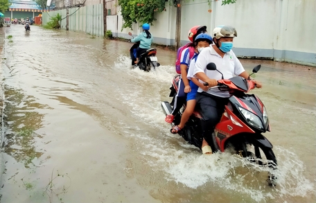
| Beware of the impact of La Nina phenomenon causing unusual rain, storms, tornadoes, and floods in the last months of 2024. Photo: Archive |
Dry season: Temperatures hit record highs, less rain than usual
According to monitoring data from the Vinh Long Province Hydrometeorological Station , in the first 5 months of this year's dry season, the temperature in all months in the province exceeded the average of many years, equivalent to or exceeding the highest temperature value in the past 46 years, since 1978.
April was the sunniest month with an average monthly temperature of 30.5 degrees Celsius, 0.9 degrees Celsius and 1.3 degrees Celsius higher than the same period last year and the average for the same period, respectively, equivalent to the historical average temperature recorded in April 1988. In addition, the absolute maximum temperature in April reached a new record of 38.5 degrees Celsius, surpassing the historical highest value of 38.3 degrees Celsius in 2010.
Along with the heat is a sharp decrease in rainfall. In February and March, there was almost no rain anywhere in the province, with total rainfall significantly lower than the same period last year, from 32-120mm, and 11-18mm lower than the average. In March, rainfall was 6-27mm short.
In April, there were 2 days of unseasonal rain concentrated in the southern and western regions of the province with insignificant rainfall, the largest being 12.6mm. In the rest of the month, there was almost no rain, the total monthly rainfall was 40-60mm lower than the average. In the first week of May, the heat wave above 38 degrees Celsius continued, but some places had seasonal rains, which somewhat reduced the heat wave.
Saltwater intrusion in our province this year's dry season came earlier than last year's dry season, but was not as severe as the dry seasons of 2015-2016 and 2019-2020. From December 7-15, 2023, saltwater intrusion appeared on the Co Chien River in Vung Liem district with salinity measured from 0.2-0.3‰.
The salinity period from March 7-15 (coinciding with the high tide period in early February of the lunar calendar) is the highest salinity period in the dry season, with the peak occurring from March 11-12, 2024 (February 2-3 of the lunar calendar) with the 4‰ salinity boundary encroaching deep into the Co Chien River branch to An Phuoc commune (Mang Thit district), about 65km from the river mouth, and on the Hau River to Tich Thien commune (Tra On district), 55km from the river mouth.
Salinity on the Co Chien River, in Vung Liem District, ranges from 3.8-5.9‰; on the Hau River, in Tra On District, ranges from 0.8-3.8‰; on the Tien River, in Dong Phu and Binh Hoa Phuoc Communes, Long Ho District, ranges from 0.2-0.3‰.
Rainy season: Beware of La Nina's effects
This El Nino phenomenon is too short-lived, from the last months of 2023 and ending at the end of the dry season in 2024, to make way for the La Nina phenomenon to return from 2022.
According to the National Center for Hydro-Meteorological Forecasting (May 10, 2024), the ENSO (El Nino-Southern Oscillation) phenomenon is maintaining a neutral state until June 2024 with a probability of 80-85%. From July to September, ENSO will shift to La Nina (cold phase) state with a probability of 60-65% and is likely to maintain this state until the end of this year.
The transition from El Nino to La Nina will cause this year's rainy and stormy season to come late, with storms and tropical depressions appearing in a short period of time. Specifically, there are forecasts for 11-13 storms and tropical depressions in the East Sea, of which 5-7 will affect Vietnam's mainland this year.
From now until the first half of June, there is little chance of storms and tropical depressions appearing, but they will be concentrated in the second half of the storm season, from September to November 2024. Due to storms and tropical depressions, rainfall in the last 6 months of the year is forecast to be approximately equal to or higher than the average.
For our country, years with La Nina often record storms and tropical depressions operating in the East Sea and affecting the mainland more than usual and the storm season often lasts until the last months of the year. Rain tends to increase more than the average in the Central and Southern regions, notably the Central Highlands and the South, during the dry season when affected by La Nina, there is often more unseasonal rain. The annual flow of rivers is often greater than the average.
The La Nina phenomenon affected our country in general and the Mekong Delta in particular in 2000-2002, 2006, 2010-2011 and most recently from 2020-2022 with the peak in 2022. La Nina in 2000-2002 caused 3 consecutive years of major floods from 2000-2002 and La Nina in 2010-2011 caused major floods in 2011 in the Mekong Delta.
2006 alone was the year with the most tropical cyclones with 16 storms and tropical depressions, especially 3 consecutive strong storms that made landfall at the end of that year: storm No. 1 (Chan Chu storm), storm No. 6 (Xangsane) in September devastated the Central region, storm No. 9 (Durian) in December devastated the South Central and Southwest regions.
In Vinh Long, the most obvious impact of La Nina in 2022 is heavy rain, record high tides and more unusual storms and tornadoes. The total annual rainfall at Vinh Long meteorological station reached 1,605.4mm, 261mm higher than the same period in 2021 and 312mm higher than the average.
The high tide rose to a new record level with the highest water level at My Thuan station (Tien River) reaching 2.17m (5cm higher than the historical high tide in 2019), at Can Tho station (Hau River) reaching 2.27m (2cm higher than the 2019 high tide), causing flooding of nearly 376ha of rice, 186ha of crops, 286ha of orchards, 5,454 houses, 10 schools, 9 markets, 26 agency headquarters; causing overflow of 47,027m of embankments, 23 dams (287m long), 60.3km of roads... causing property damage of more than 7 billion VND. Storms and tornadoes damaged 126 houses, 4,209.61ha of crops... causing damage of nearly 40 billion VND.
Weather, hydrometeorology, and natural disasters in the province in the last months of 2024 are still complicated, which is the peak period of the rainy and stormy season. Therefore, sectors and localities need to closely monitor developments to promptly develop plans and solutions to prevent, combat, and respond to unusual natural disasters.
• Article and photos: THANH THANG
Source


Comment (0)