

Location and trajectory of Typhoon No. 2. (Source: nchmf.gov.vn)
According to the National Center for Hydro-Meteorological Forecasting, at 4 PM on July 22nd, the typhoon's center was located at approximately 20.2 degrees North latitude and 108.4 degrees East longitude, in the northern part of the Gulf of Tonkin, about 80km east of Bach Long Vi Island and about 170km east-southeast of Quang Ninh - Hai Phong . The strongest winds near the center of the typhoon reached level 10 (89-102 km/h), with gusts up to level 13. The typhoon was moving northwest at a speed of approximately 10 km/h.
As of 4:00 AM on July 23rd, the storm's center was located at approximately 21.1 degrees North latitude and 107.8 degrees East longitude, over the sea off Quang Ninh - Hai Phong. The strongest winds near the storm's center were at force 9-10, with gusts up to force 13. The storm was moving northwest at a speed of about 10 km/hour.
As of 4 PM on July 23rd, the typhoon's center was located at approximately 21.7 degrees North latitude and 107.2 degrees East longitude, in the border area between Vietnam and China. The strongest winds near the center of the typhoon were at level 6, with gusts up to level 8. The typhoon was moving northwest at a speed of about 5-10 km/hour.
As of 4:00 AM on July 24th, the typhoon's center was located at approximately 22.1 degrees North latitude and 106.4 degrees East longitude, over the northern mountainous region. The strongest winds near the center of the typhoon had decreased to below level 6. The typhoon was moving in a west-northwest direction at a speed of about 5-10 km/hour.
Due to the influence of typhoon No. 2, the sea area of the Gulf of Tonkin (including Bach Long Vi and Co To islands) will experience strong winds of force 6-8, with winds near the center of the typhoon reaching force 9-10, gusting to force 13, and very rough seas.
On land, from the night of July 22nd, the Quang Ninh - Hai Phong area is likely to be affected by strong winds of level 7, near the storm's center level 8, gusting to levels 10-11; the Lang Son , Bac Giang, Thai Binh, and Nam Dinh areas will experience strong winds of levels 5-6, in some places level 7, gusting to levels 8-9.
Warning: In the Gulf of Tonkin (including Bach Long Vi and Co To islands), wave heights will be 2.5 - 4.5m, while in the coastal waters of Quang Ninh and Hai Phong provinces, wave heights will be 2 - 3m.
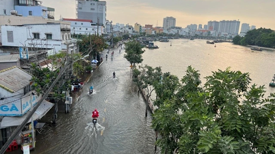
Coastal areas of Quang Ninh and Nam Dinh provinces experienced high tides (in the afternoon of July 22-23). The high tides, combined with storm surges, caused water levels at Hon Dau to reach 3.9-4.1m and at Cua Ong 4.7-4.9m, accompanied by large waves that could cause flooding in low-lying coastal and riverside areas and slow down flood drainage on rivers in the region.
Tra Vinh Online Newspaper
Source: https://www.baotravinh.vn/trong-nuoc/bao-giat-cap-13-cach-quang-ninh-hai-phong-khoang-170km-38805.html

![[Photo] Conference announcing the Politburo's Decision on organizational and personnel matters](https://vphoto.vietnam.vn/thumb/1200x675/vietnam/resource/IMAGE/2026/04/01/1775017881825_bnd-2410-1472-jpg.webp)


![[Photo] Conference on the transfer and reception of Party organizations and Party members between the Party Committee of the Government and the Party Committees of the Central Party Agencies](https://vphoto.vietnam.vn/thumb/1200x675/vietnam/resource/IMAGE/2026/04/01/1775036784472_ndo_br_bnd-2620-jpg.webp)


![[Photo] Prime Minister Pham Minh Chinh receives the Ambassador of the Russian Federation to Vietnam](https://vphoto.vietnam.vn/thumb/402x226/vietnam/resource/IMAGE/2026/04/01/1775046774818_anh-man-hinh-2026-04-01-luc-19-32-33.png)


Comment (0)