
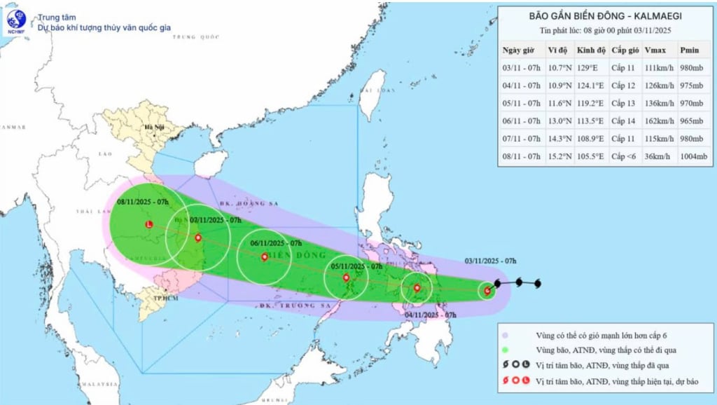
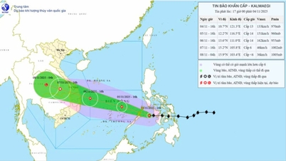
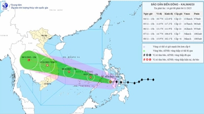
It is forecasted that in the next 24-48 hours, storm Kalmaegi will continue to move in a West-Northwest direction, at a speed of 20-25 km/h, and is likely to strengthen. By the morning of November 5, the storm's center will enter the East Sea, with strong winds of level 13, gusts of level 15, with the range of strong winds and large waves expanding over the central area of the East Sea, including the Truong Sa special zone.
From the afternoon of November 4, the sea area in the East Sea will have winds gradually increasing to level 6-7, then increasing to level 8-9; the area near the storm center will have winds of level 10-12, gusts of level 14-15, waves 5-7m high, and rough seas. On November 5-6, the sea area off the coast of Da Nang - Khanh Hoa is likely to be affected by strong winds of level 12-14, gusts above level 17, waves 8-10m high.
The National Center for Hydro-Meteorological Forecasting warns that all ships and structures operating in the above-mentioned dangerous area are strongly affected by storms, whirlwinds, strong winds, and large waves.
Source: https://quangngaitv.vn/bao-kalmaegi-kha-nang-manh-len-truoc-khi-vao-bien-dong-6509552.html
![[Photo] Ho Chi Minh City Youth Take Action for a Cleaner Environment](https://vphoto.vietnam.vn/thumb/1200x675/vietnam/resource/IMAGE/2025/11/04/1762233574890_550816358-1108586934787014-6430522970717297480-n-1-jpg.webp)

![[Photo] Panorama of the Patriotic Emulation Congress of Nhan Dan Newspaper for the period 2025-2030](https://vphoto.vietnam.vn/thumb/1200x675/vietnam/resource/IMAGE/2025/11/04/1762252775462_ndo_br_dhthiduayeuncbaond-6125-jpg.webp)
![[Photo] Ca Mau "struggling" to cope with the highest tide of the year, forecast to exceed alert level 3](https://vphoto.vietnam.vn/thumb/1200x675/vietnam/resource/IMAGE/2025/11/04/1762235371445_ndo_br_trieu-cuong-2-6486-jpg.webp)

![[Photo] The road connecting Dong Nai with Ho Chi Minh City is still unfinished after 5 years of construction.](https://vphoto.vietnam.vn/thumb/1200x675/vietnam/resource/IMAGE/2025/11/04/1762241675985_ndo_br_dji-20251104104418-0635-d-resize-1295-jpg.webp)


Comment (0)