
According to the National Center for Hydro-Meteorological Forecasting, at 1 p.m. on November 4, the center of storm Kalmaegi was located in the central region of the Philippines. The strongest wind near the center of the storm was level 13 (133-149 km/h), gusting to level 16.
In the next 12 hours, the storm will move west-southwest at a speed of about 25km/h. It is forecasted that tomorrow morning, November 5, the storm will enter the East Sea, becoming the 13th storm of the year with a level 13 intensity.
At 1:00 p.m. on November 5, the storm in the central East Sea was at level 13, gusting to level 16, moving mainly in the West Northwest direction at a speed of about 25km/h.
The following afternoon (November 6), the storm was in the middle of the East Sea, about 320km east-southeast of the coast of Gia Lai province, with a level 14 intensity, gusting to level 17 and likely to strengthen, moving in a West-Northwest direction at a speed of about 25km/h.
The Hydrometeorological Agency warned on November 6 that the central East Sea area (including the sea area north of Truong Sa special zone), the sea area from Da Nang to Khanh Hoa (including Ly Son special zone) will be directly affected by storm Kalmaegi with a natural disaster risk level of level 4.
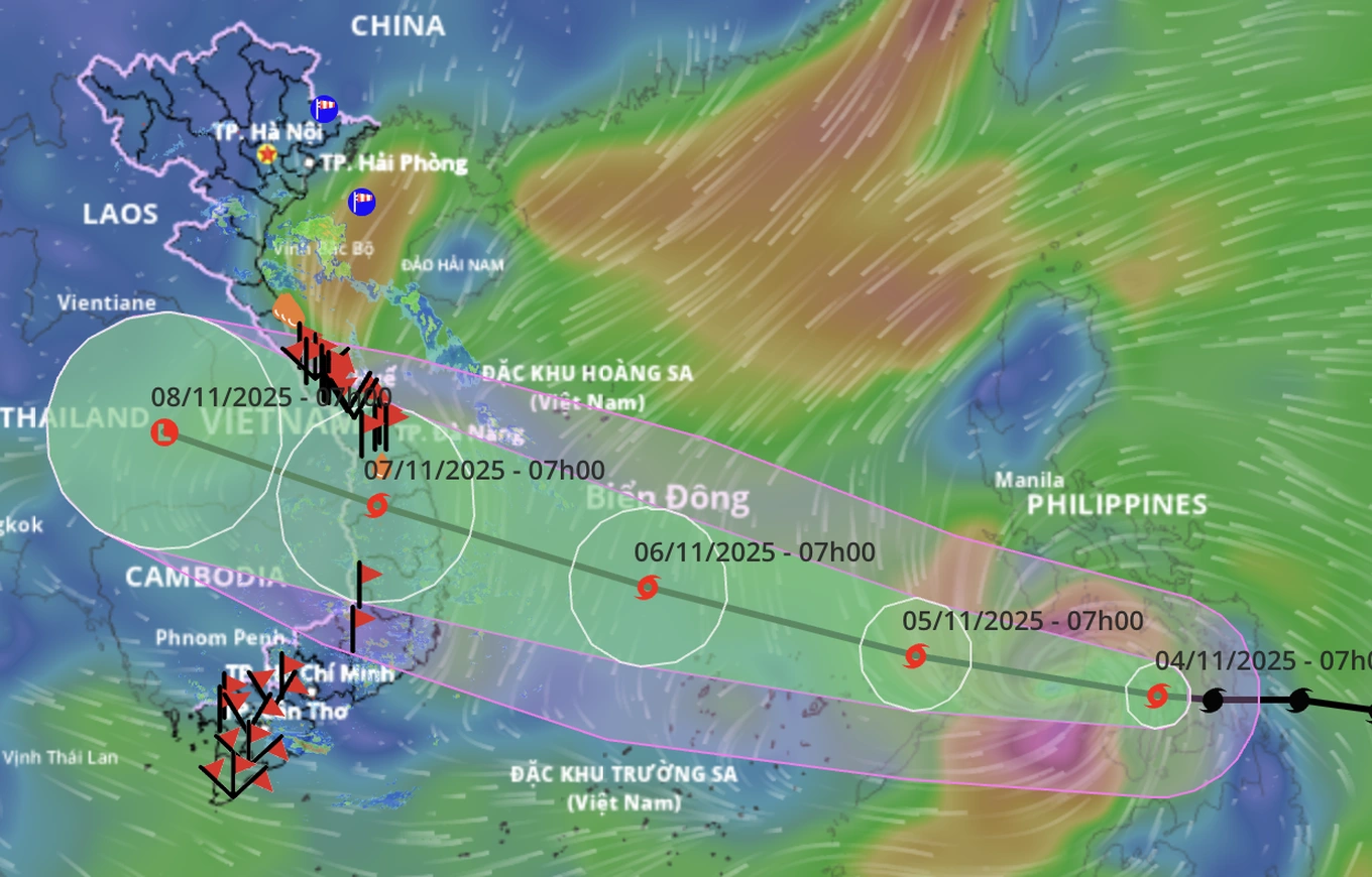
The movement of storm Kalmaegi (Photo: Vietnam Disaster Monitoring System).
After making landfall, Typhoon Kalmaegi is expected to weaken rapidly.
By 1 p.m. on November 7, the storm gradually weakened into a tropical depression with wind speed of level 7, gusting to level 8, on the mainland of Southern Laos.
The Japan Meteorological Agency said that Typhoon Kalmaegi currently has winds of about 128 km/h. By the afternoon of November 5, the storm could reach winds of 140 km/h and by the afternoon of November 6, the next day, the wind speed will be up to about 157 km/h.
According to the Hong Kong Meteorological Department, the strongest wind near the center of Typhoon Kalmaegi is maintaining at 145km/h. The station forecasts the storm will hit Gia Lai with winds of about 155km/h.
According to the National Center for Hydro-Meteorological Forecasting, due to the influence of storm Kalmaegi, the eastern sea area in the central East Sea will have winds gradually increasing to level 6-7, then increasing to level 8-10; near the center of the storm, winds will be level 11-13, gusting to level 15-16, with waves 5-7m high. The sea will be very rough.
From November 5 to 6, the central East Sea area (including the sea area north of Truong Sa special zone), the sea area off the coast of Da Nang - Khanh Hoa is likely to be affected by strong winds of level 12-14, gusting to level 17, and waves of 8-10m high. The sea will be very rough.
All ships and structures operating in the above-mentioned dangerous area are strongly affected by storms, whirlwinds, strong winds and big waves.
Dantri.com.vn
Source: https://dantri.com.vn/thoi-su/du-bao-rang-sang-mai-bao-kalmaegi-vao-bien-dong-voi-cuong-do-cap-13-20251104145126137.htm
![[Photo] Ca Mau "struggling" to cope with the highest tide of the year, forecast to exceed alert level 3](https://vphoto.vietnam.vn/thumb/1200x675/vietnam/resource/IMAGE/2025/11/04/1762235371445_ndo_br_trieu-cuong-2-6486-jpg.webp)

![[Photo] Panorama of the Patriotic Emulation Congress of Nhan Dan Newspaper for the period 2025-2030](https://vphoto.vietnam.vn/thumb/1200x675/vietnam/resource/IMAGE/2025/11/04/1762252775462_ndo_br_dhthiduayeuncbaond-6125-jpg.webp)
![[Photo] Ho Chi Minh City Youth Take Action for a Cleaner Environment](https://vphoto.vietnam.vn/thumb/1200x675/vietnam/resource/IMAGE/2025/11/04/1762233574890_550816358-1108586934787014-6430522970717297480-n-1-jpg.webp)
![[Photo] The road connecting Dong Nai with Ho Chi Minh City is still unfinished after 5 years of construction.](https://vphoto.vietnam.vn/thumb/1200x675/vietnam/resource/IMAGE/2025/11/04/1762241675985_ndo_br_dji-20251104104418-0635-d-resize-1295-jpg.webp)


Comment (0)