

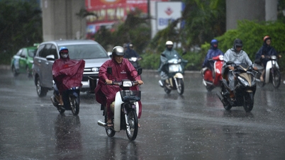
On the afternoon of November 6th, Mr. Mai Van Khiem, Director of the National Center for Meteorological and Hydrological Forecasting, stated that the western circulation of Typhoon No. 13 (Kalmaegi) is beginning to collide with the central mainland. Due to friction with the land surface, the typhoon's wind intensity will decrease by 1-2 levels compared to when it was still active at sea.
According to the National Center for Meteorological and Hydrological Forecasting, updated at 4 PM , the center of Typhoon No. 13 has moved to approximately 13.5 degrees North latitude and 110 degrees East longitude, about 90km east-southeast of Quy Nhon ( Gia Lai ). At this time, the typhoon is still at level 14, with gusts up to level 17.
The National Center for Meteorological and Hydrological Forecasting predicts that when the storm's center makes landfall this evening and tonight, it will weaken, but the strongest winds will still reach levels 11 to 13, with gusts up to levels 15-16. Mr. Mai Van Khiem warned that this is a very strong intensity, enough to cause violent gusts of wind, large waves, and exceptionally heavy rain in coastal areas of Central Vietnam.
. Source: Z.E")
According to the Director of the National Center for Meteorological and Hydrological Forecasting, the most dangerous areas are the eastern part of Quang Ngai province and Gia Lai province, where strong winds could exceed level 12. Heavy rain began from the afternoon to the night of November 6th, continuing into the morning of November 7th, with a high risk of flash floods and landslides in the western mountainous areas.

Localities from Quang Ngai to Khanh Hoa and the Central Highlands need to closely monitor the storm's developments and proactively respond to heavy rain, strong winds, and high tides. People in these areas should avoid going outside from this afternoon until tomorrow morning. At the same time, households living in areas at risk of landslides and flash floods should evacuate immediately to safer locations.
Source: https://www.sggp.org.vn/bao-so-13-do-bo-dat-lien-co-the-giat-cap-15-16-post822105.html


![[Image] National Assembly discusses the implementation of the socio-economic development plan.](https://vphoto.vietnam.vn/thumb/1200x675/vietnam/resource/IMAGE/2026/04/20/1776696707422_ndo_br_img-20260420-185419-jpg.webp)
![[Photo] General Secretary and President To Lam meets with National Assembly delegates from ethnic minorities.](https://vphoto.vietnam.vn/thumb/1200x675/vietnam/resource/IMAGE/2026/04/20/1776696701056_a1-bnd-8331-3342-jpg.webp)


Comment (0)