
Storm No. 13 Kalmaegi moves at a very fast speed of 30km/h, its intensity is still very strong, causing heavy rain from today in a series of central provinces.
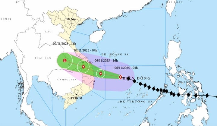
According to the National Center for Hydro-Meteorological Forecasting, at 6:00 a.m. today, November 6, Storm No. 13 Kalmaegi about 360km East Southeast of Quy Nhon ( Gia Lai ).
The storm remains very strong, level 14 (150-166km/h), gusting to level 17. It is forecasted that in the next 3 hours, the storm will move quickly, mainly to the West, at a speed of about 30km/h.
With a fast moving speed of 25-30km/h in the West Northwest direction, at about 4:00 p.m. the same day, the storm center was about 120km east of Quy Nhon (Gia Lai), the intensity showed no signs of decreasing with the strongest wind near the storm center at level 14, gusting.
The meteorological agency warned of a level 4 natural disaster risk (very dangerous) in the central East Sea area, the sea area from Quang Ngai to Dak Lak (including Ly Son special zone).
Level 3 natural disaster risk in the sea area from South Quang Tri to Da Nang City (including Cu Lao Cham Island) and Khanh Hoa. The mainland from South Quang Tri to Da Nang City, the East of the provinces from Quang Ngai to Dak Lak and the North of Khanh Hoa province.
Around the night of November 6 to early morning of November 7, storm No. 13 Kalmaegi made landfall in the provinces of Quang Ngai - Gia Lai, with its intensity decreasing.
At 4am on November 7, storm number 13 Kalmaegi in the western border area of Quang Ngai province - Southern Laos, moving rapidly in the West-Northwest direction, about 25km per hour. The storm intensity decreased to level 9, gusting to level 11.
The meteorological agency still warns of level 4 natural disaster risk in the sea area from Quang Ngai to Dak Lak (including Ly Son special zone); the eastern mainland area from Quang Ngai to Gia Lai.
Level 3 disaster risk warning in the sea area from South Quang Tri to Da Nang City (including Cu Lao Cham Island) and Khanh Hoa; mainland from South Quang Tri to Da Nang City, west of Quang Ngai and Gia Lai provinces, east of Dak Lak province and north of Khanh Hoa province.
At 4:00 p.m. on November 7, storm No. 13 Kalmaegi in the eastern region of Thailand, moving in the West-Northwest direction at a speed of about 25km/h, moved deep into the mainland and weakened into a tropical depression, then a low pressure area.
Impact of storm No. 13 Kalmaegi, the central East Sea area has strong winds of level 8-11, the area near the storm's eye has strong winds of level 12-14, gusts of level 17, waves 5-7m high, the area near the storm's eye has waves of 8-10m high, the sea is very rough.
From the morning of November 6, the sea area from South Quang Tri to Khanh Hoa (including Ly Son special zone, Cu Lao Cham island) will have winds gradually increasing to level 6-7, then increasing to level 8-11, waves 3-6m high, the area near the storm center will have strong winds of level 12-14, gusts of level 17, waves 7-9m high, and very rough seas.
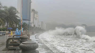
Coastal areas from Hue City to Dak Lak are experiencing storm surges of 0.4-0.8m. From the afternoon of November 6, coastal areas from Hue City to Dak Lak are on alert for rising sea levels accompanied by large waves causing flooding in low-lying areas, waves overflowing dikes, coastal roads, coastal erosion, and slowing down flood drainage in the area.
All ships, boats, and aquaculture areas in the above-mentioned dangerous areas are strongly affected by storms, whirlwinds, strong winds, big waves, and rising sea levels.
From the evening of November 6, on the mainland from the South of Da Nang City to Dak Lak, the wind gradually increased to level 6-7, then increased to level 8-9, the area near the storm's eye passed through level 10-12 (focusing on the East of Quang Ngai - Gia Lai provinces), gusting to level 14-15. From the South of Quang Tri to the North of Da Nang City and the North of Khanh Hoa province, the wind increased to level 6-7, gusting to level 8-9.
From the evening and night of November 6, in the West of the provinces from Quang Ngai to Gia Lai, the wind will gradually increase to level 6-7, near the storm's eye, it will be level 8-9, gusting to level 11.
On November 6-7, from Da Nang City to Dak Lak, there will be very heavy rain, with rainfall ranging from 200-400mm/period, and over 600mm/period in some places. From Quang Tri Province to Hue City, Khanh Hoa Province and Lam Dong Province, there will be heavy rain, with rainfall ranging from 150-300mm/period, locally. very heavy rain over 450mm/batch.
From November 8, heavy rain in the above areas tends to decrease.
On November 7-8, from North Quang Tri to Thanh Hoa, there will be moderate to heavy rain, with rainfall of 50-150mm/period, and in some places, very heavy rain over 200mm/period.
Risk of heavy rain, over 200mm in 3 hours.
In addition, the impact of the wide storm circulation, the risk of thunderstorms, tornadoes and strong gusts of wind both before and during the storm.
Source: https://baolangson.vn/bao-so-13-kalmaegi-tang-toc-giat-cap-17-tu-hom-nay-mien-trung-mua-nhu-trut-5064065.html


![[Photo] Closing of the 14th Conference of the 13th Party Central Committee](https://vphoto.vietnam.vn/thumb/1200x675/vietnam/resource/IMAGE/2025/11/06/1762404919012_a1-bnd-5975-5183-jpg.webp)


Comment (0)