
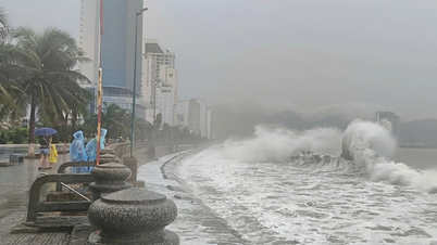
At 10am this morning (November 6), storm number 13 had strengthened to level 15, gusting to level 17 and was about 270km east-southeast of Quy Nhon ( Gia Lai ).
. Photo: NCHMF.")
The location of storm No. 13 at 10am this morning was 270km from Quy Nhon (Gia Lai). Photo: NCHMF .
According to the National Center for Hydro-Meteorological Forecasting, along with very strong and dangerous winds, it is forecasted that from November 6 to the end of November 7, the area from Da Nang to Dak Lak will have very heavy rain, with rainfall ranging from 200-400mm, in some places exceeding 600mm. The areas from southern Quang Tri to Hue City, Khanh Hoa and Lam Dong will have heavy to very heavy rain, with rainfall ranging from 150-300mm, in some places exceeding 450mm.
During the day and night of November 7, rain will spread to the area from Thanh Hoa to northern Quang Tri , generally 50-100mm, in some places over 150mm. The hydrometeorological agency warns that heavy rain of over 200mm may occur within 3 hours. During thunderstorms, there is a possibility of tornadoes, lightning, hail and strong gusts of wind. Heavy rain can cause flash floods, landslides in mountainous areas and flooding in low-lying areas.

Forecast of rain areas in the next 24 hours due to storm No. 13 across the central provinces, the red area has the heaviest rain. Photo: NCHMF .
From November 8, heavy rain in the area from southern Quang Tri to Lam Dong tends to decrease. On November 8, the area from Thanh Hoa to northern Quang Tri will still have moderate to heavy rain (20-50mm), locally very heavy rain over 80mm. From the night of November 8, the rain will decrease completely.
Floods rising on rivers, risk of landslides and flash floods
Currently, floods on rivers in Hue City and Da Nang City are receding. Water levels on other rivers from Quang Tri to Lam Dong are fluctuating.
Due to heavy rain, floods are forecasted to occur on rivers from Quang Tri to Lam Dong. Flood peaks on Bo and Huong rivers (Hue); Vu Gia - Thu Bon rivers (Da Nang); Tra Khuc, Ve and Se San rivers (Quang Ngai); Kon river (Gia Lai); Ba, Ky Lo and Srepok rivers (Dak Lak) may reach alert levels 2-3 and above alert level 3.
Kien Giang River (Quang Tri), An Lao and Lai Giang (Gia Lai), Dinh Ninh Hoa (Khanh Hoa), and rivers in Lam Dong are likely to exceed alert level 2.
Gianh River, Thach Han River (Quang Tri), Cai Nha Trang River (Khanh Hoa) exceeded alert level 1.
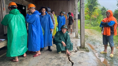
With this flood level, the hydrometeorological agency warned of a high risk of flooding in low-lying areas along rivers, urban areas, and residential areas from Quang Tri to Lam Dong; flash floods and landslides in mountainous areas of the above provinces.
Heavy rains can cause flooding in low-lying areas, urban areas, industrial zones; there is a risk of flash floods on small rivers and streams and landslides on steep slopes. People and local authorities need to monitor and update real-time warning information on flash floods and landslides on the website of the Department of Hydrometeorology: https://luquetsatlo.nchmf.gov.vn, to proactively respond in the coming time.
Currently, the Department of Dyke Management and Natural Disaster Prevention and Control has organized a 24/7 duty, closely monitoring the developments of storms and floods to promptly advise on direction and response; coordinated with Zalo Vietnam to send text messages instructing on boat safety in response to storms to 6 million people in coastal communes from Ha Tinh to Binh Thuan.
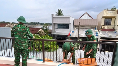
Coastal provinces and cities from Ha Tinh to Lam Dong deploy storm response measures according to Official Dispatch No. 208/CD-TTg dated November 4, 2025 of the Prime Minister; Official Dispatches No. 25/CD-BCĐ-BNNMT dated November 2, 2025; No. 26/CD-BCĐ-BNNMT dated November 4, 2025 of the National Civil Defense Steering Committee, of which 9 provinces and cities have issued official dispatches and directive documents.
Provinces and cities have proactively deployed response measures, operated and regulated reservoirs to ensure safety; developed plans and scenarios for evacuating people in areas affected by storms, floods, inundation, flash floods, and landslides. In particular, Gia Lai province has organized the evacuation of 2,337 households/7,097 people. Khanh Hoa and Gia Lai provinces have allowed students to stay home from school on November 6-7. Da Nang city and Gia Lai province have established a forward command committee to focus on commanding storm prevention work.
Source: https://nongnghiepmoitruong.vn/bao-so-13-manh-len-cap-15-du-bao-gay-mua-het-dai-mien-trung-d782624.html


![[Photo] Closing of the 14th Conference of the 13th Party Central Committee](https://vphoto.vietnam.vn/thumb/1200x675/vietnam/resource/IMAGE/2025/11/06/1762404919012_a1-bnd-5975-5183-jpg.webp)


![Building a 'fortress' against natural disasters: [Part 2] Changing state from passive to active](https://vphoto.vietnam.vn/thumb/402x226/vietnam/resource/IMAGE/2025/11/06/1762423529917_0242-2223-160125_902.jpeg)


Comment (0)