
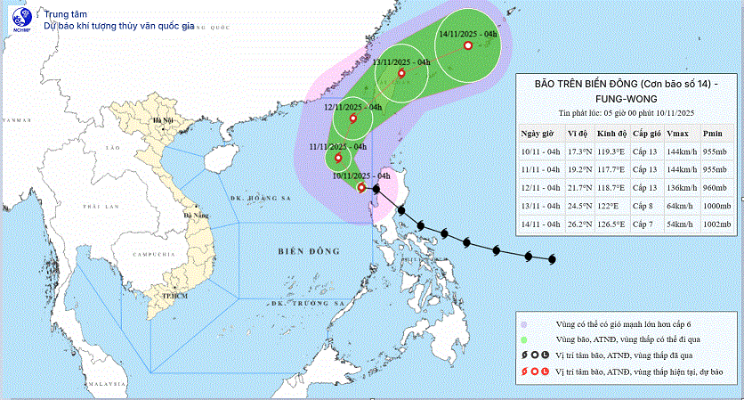
According to the National Center for Hydro-Meteorological Forecasting, early on the morning of November 10, storm Fung-wong entered the eastern sea area of the northern East Sea, becoming storm number 14 in 2025.
At 4:00 a.m., the center of the storm was at about 17.3 degrees north latitude; 119.3 degrees east longitude, in the sea area east of the northern East Sea. The strongest wind near the center of the storm was level 13 (134-149 km/h), gusting to level 16. The storm moved west-northwest at a speed of about 25 km/h.
In the next 24 hours, the storm is forecast to move northwest at a speed of 10-15 km/h. At 4:00 a.m. on November 11, the center of the storm was at about 19.2 degrees north latitude; 117.7 degrees east longitude, in the eastern sea area of the northern East Sea. The storm intensity is level 13, gusting to level 16.
Danger zone from about 15 to 21 degrees north latitude; east of longitude 116 degrees east. Disaster risk level 3 for the sea area east of the northern East Sea.
Forecast in the next 48 hours, the storm will move in a north-northeast direction, speed 10-15 km/h. At 4:00 a.m. on November 12, the center of the storm will be at about 21.7 degrees north latitude; 118.7 degrees east longitude, in the northeastern sea area of the northern East Sea. Storm intensity level 13, gust level 16.
Danger zone from about 17.5 to 23.5 degrees north latitude; east of longitude 116 degrees east. Disaster risk level 3 for the sea area east of the northern East Sea.
In the next 72 hours, the storm is forecast to move northeast at a speed of 15-20 km/h. At 4:00 a.m. on November 13, the center of the storm was at about 26.2 degrees north latitude; 126.5 degrees east longitude, on the northeastern coastal area of Taiwan. The storm gradually weakened to level 8, gusting to level 10.
Danger zone north of latitude 19.5 degrees north; east of longitude 117 degrees east. Natural disaster risk level 3 for the northeastern sea area of the northern East Sea.
From the next 72 to 96 hours, the storm continued to move in the east-northeast direction, traveling 20-25 km per hour and continued to weaken.
Warning of strong winds and high waves at sea . The eastern sea area of the northern East Sea has strong winds of level 8 - 10; the area near the storm's eye has strong winds of level 11 - 13, gusting to level 16. Waves are 5 - 8m high; the area near the storm's eye is 8 - 10m. The sea is very rough.
All vessels operating in the above mentioned dangerous sea areas are susceptible to storms, whirlwinds, strong winds and large waves, and should take precautions.
According to Lao Dong Newspaper
Source: https://baotuyenquang.com.vn/xa-hoi/202511/bao-so-14-fung-wong-giat-cap-16-tren-bien-dong-cuong-do-rat-manh-2-ngay-toi-25a7e88/


![Dong Nai OCOP transition: [Article 3] Linking tourism with OCOP product consumption](https://vphoto.vietnam.vn/thumb/402x226/vietnam/resource/IMAGE/2025/11/10/1762739199309_1324-2740-7_n-162543_981.jpeg)


Comment (0)