
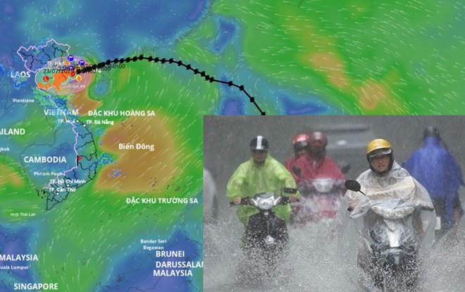
Storm No. 3 Wipha is forecast to make landfall in Hai Phong - Thanh Hoa from noon to afternoon today, July 22. Storm location source: Vietnam Disaster Monitoring System
Due to the impact of storm No. 3, in Bach Long Vi special zone, there were strong winds of level 10, gusts of level 12; Co To special zone had strong winds of level 8, gusts of level 11; Cat Ba (Cat Hai special zone) had strong winds of level 6, gusts of level 8; Cua Ong had strong winds of level 9, gusts of level 12; Bai Chay had strong winds of level 8, gusts of level 9; Quang Ha had strong winds of level 8; Tien Yen had strong winds of level 7, gusts of level 9; Thai Binh station had strong winds of level 7, gusts of level 8; Mong Cai had strong winds of level 6, gusts of level 9; Phu Lien had strong winds of level 6, gusts of level 8.
In the Northern Delta and coastal areas, Thanh Hoa and Nghe An, there will be moderate rain, heavy rain, and in some places very heavy rain with common rainfall of 50-100 mm, in some places over 130 mm.
Storm No. 3 is level 8 with level 10 gusts when making landfall.
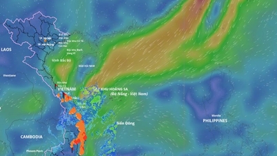
At 4:00 a.m. on July 22 , the center of the storm was at about 20.5 degrees north latitude; 107.2 degrees east longitude, about 140 km from Quang Ninh, 70 km from Hai Phong, about 80 km from Hung Yen, and about 100 km from Ninh Binh. The strongest wind near the center of the storm was level 9-10 (75-102 km/h), gusting to level 13. The storm moved west-southwest at a speed of about 15 km/h.
In the next 12 hours, the storm is forecast to move west-southwest at a speed of about 10-15 km/hour. At 4:00 p.m. on July 22, the storm's center will be at about 20.3 degrees north latitude; 106.1 degrees east longitude, on the mainland from Hai Phong to Thanh Hoa. The strongest wind near the storm's center is at level 8, gusting to level 10.
The danger zone is north of 18.5 degrees north latitude, west of 109 degrees east longitude. The level of natural disaster risk due to storm level 3 with the affected area including the Gulf of Tonkin, coastal waters and mainland provinces from Quang Ninh to Thanh Hoa.
Forecast in the next 24 hours , the storm will move west-southwest at a speed of about 10-15 km/hour. At 4:00 a.m. on July 23, the center of the low pressure area will be at about 20.1 degrees north latitude; 104.7 degrees east longitude, on the Vietnam - Laos border area. Wind force below level 6.
The strongest storm today 7/22
At sea , the northern Gulf of Tonkin, including the special zones of Bach Long Vi, Co To, Van Don, Cat Hai, and Hon Dau Island, has strong winds of level 7-8, and near the eye of the storm, level 9-10, gusting to level 13. Waves are 2-4 m high, and 3-5 m near the eye of the storm, with very rough seas. The southern Gulf of Tonkin, including Hon Ngu Island, has strong winds of level 6-7, and near the eye of the storm, level 8, gusting to level 11. Waves are 2-4 m high, and rough seas.
Coastal areas from Hung Yen to Quang Ninh have storm surges of 0.5-1.0 m. Water levels in Ba Lat (Hung Yen) are 2.4-2.6 m high, in Hon Dau (Hai Phong) are 3.9-4.1 m high, in Cua Ong (Quang Ninh) are 4.6-5.0 m high and in Tra Co (Quang Ninh) are 3.6-4.0 m high. There is a high risk of flooding in coastal areas and river mouths at noon and afternoon on July 22.
Warning, the weather at sea and in coastal areas during the storm is extremely dangerous, unsafe for any vehicle or structure operating in the danger zone such as cruise ships, passenger ships, transport ships, cages, aquaculture areas, dykes, embankments, coastal routes. Vehicles are highly likely to be capsized, destroyed, flooded due to strong winds, storms, whirlwinds, big waves and rising sea levels.
On land , coastal areas from Quang Ninh to Nghe An have strong winds of level 7-8, near the storm center level 9-10, gusting to level 13. Inland areas of the provinces and cities of Hai Phong, Hung Yen, Bac Ninh, Hanoi, Ninh Binh and Thanh Hoa have strong winds of level 6, gusting to level 7-8. Level 9-10 winds can knock down trees, electric poles, and blow off roofs, causing very heavy damage.
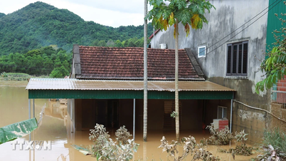
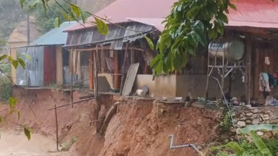
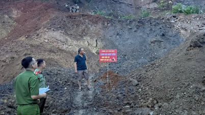
Regarding heavy rain , from early morning of July 22 to July 23, in the Northern Delta, Thanh Hoa and Nghe An, there will be heavy to very heavy rain and thunderstorms with common rainfall of 200-300 mm, locally over 500 mm. Other places in the Northern region and Ha Tinh will have moderate rain, heavy rain, some places very heavy rain and thunderstorms with common rainfall of 70-150 mm, locally over 250 mm. Warning of the risk of heavy rain over 150 mm in 3 hours. Heavy rain in a short period of time can cause flash floods, landslides in mountainous areas, and flooding in low-lying areas.
Laodong.vn
Source: https://laodong.vn/moi-truong/bao-so-3-wipha-sap-do-bo-du-bao-thoi-gian-gay-mua-to-gio-manh-nhat-1544409.ldo
![[Photo] Prime Minister Pham Minh Chinh attends the opening of the 47th ASEAN Summit](https://vphoto.vietnam.vn/thumb/1200x675/vietnam/resource/IMAGE/2025/10/26/1761452925332_c2a-jpg.webp)

![[Photo] Enjoy the Liuyang Fireworks Festival in Hunan, China](https://vphoto.vietnam.vn/thumb/1200x675/vietnam/resource/IMAGE/2025/10/26/1761463428882_ndo_br_02-1-my-1-jpg.webp)

![[Photo] General Secretary To Lam received the delegation attending the international conference on Vietnam studies](https://vphoto.vietnam.vn/thumb/1200x675/vietnam/resource/IMAGE/2025/10/26/1761456527874_a1-bnd-5260-7947-jpg.webp)


Comment (0)