
PV: Can you give an overview of the recent heavy rains in Ha Tinh and storm Kalmaegi (storm number 13)?
Mr. Tran Duc Ba: Due to the influence of the cold air combined with the high-altitude easterly wind, from the night of October 29 to November 4, Ha Tinh experienced moderate rain, heavy rain, and in some places very heavy rain. The amount of rain measured at automatic rain gauge stations from 7 p.m. October 29 to 7 a.m. November 4 was generally from 600 to 1,500 mm. Prolonged heavy rain and the overflow of Ke Go Lake caused flooding in many localities.
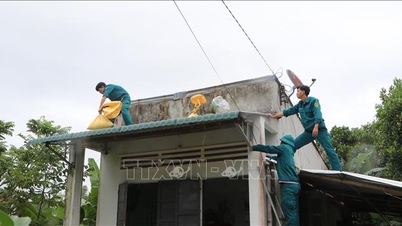
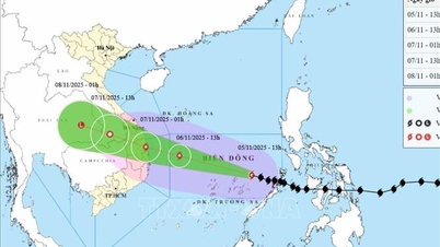
Currently, floodwaters in some localities such as Cam Binh, Cam Due, Ha Huy Tap ward... have not yet receded, but this morning (November 5), storm Kalmaegi entered the eastern sea area of the central East Sea, becoming the 13th storm in 2025 and is having many complicated developments. It is forecast that this storm will make landfall directly in the South Central region; Ha Tinh is likely to be affected by the storm circulation, with heavy rain concentrated in the southern plains and coastal areas.
It is forecasted that in the next 24 hours, storm No. 13 will move in the West Northwest direction at a speed of about 25 km/hour. At 4:00 a.m. on November 6, the center of the storm will be at about 12.8 degrees north latitude; 113.9 degrees east longitude, about 550 km east southeast of the coast of Gia Lai province.

Many households in Cam Due commune - downstream of Ke Go lake, are still flooded.
PV: In your opinion, what is the reason for this year's extreme and unusual weather with many big storms and high rainfall?
Mr. Tran Duc Ba: 2025 is a year of extreme weather and dangerous natural disasters in most regions of the country. Ha Tinh in particular has been directly affected by 3 storms since the beginning of the year (number 5, number 6, number 10). Notably, this is the first year in history that storms number 5 and number 10 both had wind gusts of level 13-14, making landfall just 1 month apart, causing heavy damage.
In addition to direct impacts, Ha Tinh is also affected by many other extreme weather conditions, causing many heavy rains. In the first 10 months of 2025, rainfall in the area reached 2,200 - 3,970 mm, 15 - 44% higher than the average of many years; in the southern coastal area alone, it was 70 - 80% higher. In addition to high rainfall, the number of rainy days was also high, and the rain lasted continuously.

In the 10 months of 2025, rainfall in Ha Tinh reached 2,200 - 3,970 mm, 15 - 44% higher than the average of many years.
Through monitoring, the unusual weather developments this year are dominated by neutral Enso conditions. In the ocean-atmosphere system, Enso (El Niño - Southern Oscillation) is often divided into 3 phases: the hot phase is El Nino, the cold phase is La Nina and the neutral Enso phase. The neutral Enso phase is an intermediate state with weather manifestations that do not lean towards hot or cold, having a balance between the two remaining phases.
This state of equilibrium makes the weather more volatile and difficult to predict. Along with the impact of climate change, extreme weather events with increased frequency and intensity have appeared more often. This makes forecasting more difficult, requiring localities to be proactive and improve their response capacity.

Early this morning, Typhoon Kalmaegi entered the eastern sea area of the central South China Sea, becoming the 13th typhoon in the South China Sea in 2025.
PV: Given the complicated weather developments, what solutions should Ha Tinh implement to proactively respond to storm No. 13?
Mr. Tran Duc Ba: After the recent prolonged heavy rain, soil moisture in many areas has reached saturation, causing a sharp decrease in water absorption capacity. Meanwhile, storm No. 13 is forecast to continue causing rain in the plains and coastal areas in the south of the province, with rainfall ranging from 50 - 150 mm, locally over 200 mm/period, mainly concentrated on November 7 - 8. Therefore, the risk of flooding, landslides and flash floods in mountainous areas, slopes, riverbanks and streams is increasing.
Relevant departments, branches, sectors and units need to coordinate closely in information, flood regulation, and flexible and safe reservoir operation, based on the development of rain, high tides and upstream water flow. Local authorities must carefully review areas at high risk of landslides, deep flooding, and downstream areas of reservoirs to proactively take preventive measures; ensure traffic safety on key routes, especially unfinished construction projects that are prone to landslides during heavy rains.

The risk of flooding, landslides and flash floods in mountainous areas, steep slopes, riverside and stream areas is very high, especially in the southern localities of the province.
Information and warning work needs to be carried out regularly, directly notified to each household in high-risk areas to detect early signs of abnormalities and proactively evacuate to ensure safety.
The hydrometeorological sector continues to closely monitor the developments of storm No. 13, providing timely information to serve the direction and management of authorities at all levels. We also recommend that people regularly update forecasts and warnings, and not be subjective in the face of extreme weather situations.
Source: https://baohatinh.vn/chuyen-gia-canh-bao-nguy-co-anh-huong-cua-bao-so-13-den-ha-tinh-post298806.html


![[Photo] Opening of the 14th Conference of the 13th Party Central Committee](https://vphoto.vietnam.vn/thumb/1200x675/vietnam/resource/IMAGE/2025/11/05/1762310995216_a5-bnd-5742-5255-jpg.webp)


![[Photo] Panorama of the Patriotic Emulation Congress of Nhan Dan Newspaper for the period 2025-2030](https://vphoto.vietnam.vn/thumb/1200x675/vietnam/resource/IMAGE/2025/11/04/1762252775462_ndo_br_dhthiduayeuncbaond-6125-jpg.webp)


Comment (0)