
What is special about the Nha Trang City Master Plan Adjustment Project?
Nha Trang will promote its brand as a coastal resort city nationally and internationally, through upgrading the quality of urban space and tourism, attracting international-class tourism investors.
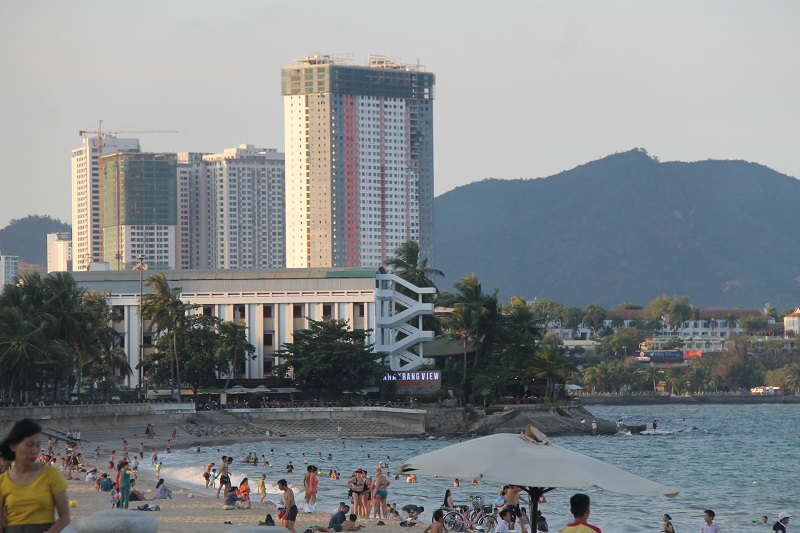 |
| Nha Trang City is a core urban area, attracting international-class tourism investors. |
Nha Trang City is a core urban area, attracting international-class tourism investors.
The Prime Minister has just approved the Project to Adjust the General Planning of Nha Trang City, Khanh Hoa Province to 2040. Accordingly, the planning scale has a total natural land area of about 26,736 hectares, an increase of about 189 hectares compared to the research scope area in Decision No. 1456/QD-TTg dated September 25, 2020 of the Prime Minister of 26,547 hectares.
Of which, Nha Trang city has an area of about 25,422 hectares, an increase of 162 hectares compared to the research scope of 25,260 hectares due to updating according to the area of Nha Trang city in the Khanh Hoa Provincial Planning for the period 2021 - 2030, with a vision to 2050 approved in Decision No. 318/QD-TTg dated March 29, 2023 of the Prime Minister; Dien Khanh district has an area of about 1,314 hectares, an increase of 27 hectares compared to the research scope of 1,287 hectares due to updating the current topographic map at a scale of 1/10,000 appraised by competent authorities.
The objective of the Project to Adjust the General Planning of Nha Trang City, Khanh Hoa Province to 2040 is to promote the brand of a coastal resort city to the national and international community, through upgrading the quality of urban space and tourism, attracting international-class tourism investors, diversifying tourism products, sustainably exploiting existing tourism resources, with the unique highlight of the coastal space chain, island space and ecological space; supporting the development of maritime logistics services, trade - tourism services combined with environmental protection; investing in new and continuing to complete and improve the quality of key technical infrastructure works (seaports, warehouses, railways, key bus stations) and key traffic routes; completing and upgrading the urban social - technical infrastructure system; moving towards enhancing the international brand position of a coastal resort city; initially become a financial and commercial city of national and regional stature in Southeast Asia.
The Project to Adjust the General Planning of Nha Trang City, Khanh Hoa Province to 2040 also specifies the goals and orientations for the construction and development of Khanh Hoa Province to 2030, with a vision to 2045 according to Resolution No. 09-NQ/TW dated January 28, 2022 of the Politburo and the Planning of Khanh Hoa Province for the period 2021 - 2030, with a vision to 2050 approved in Decision No. 318/QD-TTg dated March 29, 2023 of the Prime Minister: Nha Trang City is a core urban area, an economic, political, cultural, social, scientific, technological, and human resource training center; further effectively promoting the role of an important growth pole and international integration gateway of Khanh Hoa Province.
In terms of nature, Nha Trang city is the economic, scientific, technical, educational and medical center of the South Central Coast and Central Highlands; the administrative, political, economic, cultural, scientific and technical center of Khanh Hoa province; the center of tourism, trade - finance, seaport tourism services of the South Central Coast and the whole country; a national and international sea and island tourist city; has an important role and position in national security and defense and marine environmental protection. In terms of population size, by 2030: about 630,000 - 640,000 people; by 2040: about 750,000 - 780,000 people. In terms of land size, by 2030: the entire urban construction land is about 9,981 hectares (average about 156 m2/person); Of which, civil land is about 5,873 ha (average about 92 m2/person); by 2040, the total urban construction land is about 11,792 ha (average about 151 m2/person); of which, civil land is about 6,713 ha (average about 86 m2/person).
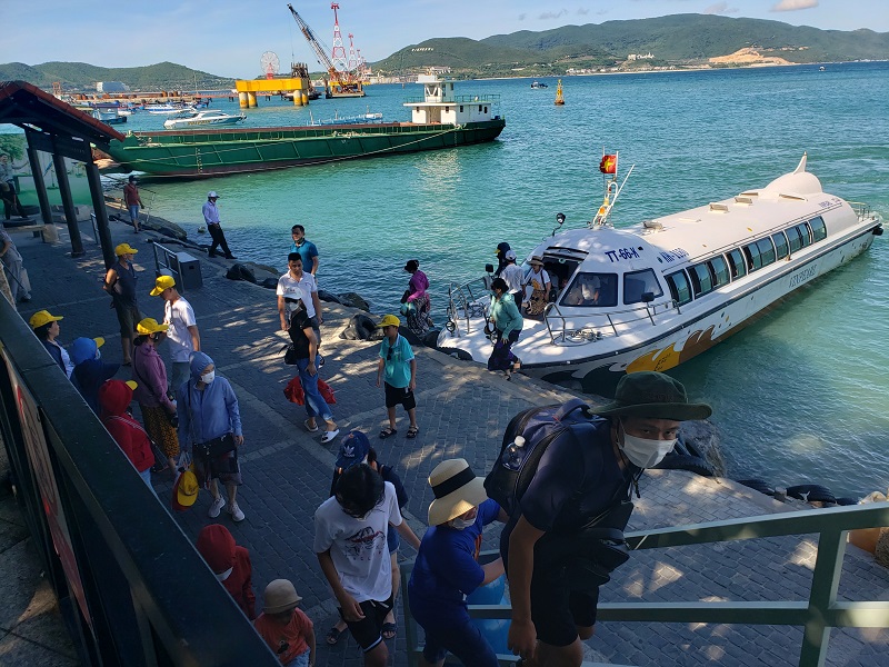 |
| Nha Trang is a national and international sea and island tourist city. |
Development orientation of 14 regions
Regarding the development orientation of urban zones, the Project to Adjust the General Planning of Nha Trang City, Khanh Hoa Province to 2040 orients the development of Nha Trang City to include 14 areas.
Zone 1 - The central coastal area and the southern part of Cai River, with an area of about 676 hectares and an estimated population of about 140,000 people; is the national tourist center; the administrative - cultural - commercial center at the provincial and municipal levels. Zone 1 will develop a coastal park, attracting entertainment activities, public exchanges, and serving swimming activities well; renovating the Nha Trang railway station area to develop it into a park associated with a museum at Nha Trang Station and service and resettlement streets; building a new public park and a new urban center along the southern part of Cai River; renovating and upgrading the provincial administrative center on Tran Phu Street.
Zone 2 - The old Nha Trang airport area and surrounding areas, with an area of about 263 hectares, an estimated population of about 23,200 people; is the center of tourism services, offices, trade and finance in the South Central region. This area will develop a new central urban area (CBD), focusing on trade and finance services and tourism services; encourage the development of underground construction space; organize convenient traffic connections from Vo Nguyen Giap Street to the main urban axis, ending at Dai Duong Square integrating museum, exhibition, and multi-purpose cultural services functions into a complex of key works, safely and conveniently connected to the coastal park space.
Zone 3 - Phuoc Long, Vinh Truong, Vinh Nguyen area, area of about 640 hectares, estimated population of about 60,500 people; is the center of sea tourism services, seaport tourism services in the South Central region. This area is oriented to build Nha Trang port combined with international tourist port; renovate and upgrade Vinh Truong coastal residential area, add infrastructure facilities and develop walking street, combine community tourism services; develop and complete tourist areas, urban areas on Chut Mountain, comply with regulations in National Technical Regulations on construction planning.
Zone 4 - Area west of Le Hong Phong Street, area of about 501 hectares, estimated population of about 70,000 people; is a new urban area interspersed with existing residential areas for renovation and refurbishment. This area encourages the integration of land plot areas, building blocks, raising building heights, reducing construction density, mixed land use, increasing land use efficiency, creating conditions for the development of service economy and urban economy; supplementing solutions to ensure the quality of living environment and active drainage for existing residential areas with lower ground elevations than the new urban area.
Zone 5 - Coastal urban area, east of the railway - from the North of Cai River to Mui Ke Ga, area of about 1,212 hectares, estimated population of about 108,800 people; is the existing urban center, coastal tourism services. Zone 5 will continue to promote the value of the coastal urban strip, develop a number of high-rise coastal highlight works and clusters, in areas with remaining land funds that can be converted to function or architectural form; renovate and expand beaches and public parks in the area from the North end of Tran Phu Bridge to Vinh Hoa beach area; plan to build parks and cultural and artistic centers in the Nhat Tri islet area, combined with urban embellishment along 2/4 Street; renovate and upgrade Ngoc Thao islet residential area, add a number of new urban functions and resettlement (from Nhat Tri islet area), develop ecological urban areas.
Zone 6 - The area from the south of Co Tien Mountain (small) to the north of Hon Ngang Mountain (large Co Tien Mountain), with an area of about 1,631 hectares, an estimated population of about 16,100 people; is the existing urban center, coastal tourism services. This area will be upgraded, renovated existing urban areas and supplemented with service and tourism functions in the area west of Vinh Hoa Lake, connecting with the area west of National Highway 1; developing thematic parks, public parks for experience, mountain climbing, sightseeing..., at locations with beautiful views, arranging public sightseeing spots, with small-scale utilities and services; developing mountain service and eco-tourism areas, complying with the regulations in the National Technical Regulations on construction planning.
Zone 7 - Urban area north of Cai River and Hon Nghe area, area of about 1,316 ha, estimated population of about 47,600 people; is the center of education, health care, hot mineral water services. Zone 7 will preserve the landscape and build a riverside park convenient for people and tourists to access and use; organize the urban area associated with the professional education center in Hon Nghe area; develop the urban area associated with the landscape of the park - regulating lake and hot mineral water services in Vinh Phuong, ensuring the role of supporting flood drainage; renovate and upgrade the infrastructure and landscape of the current residential area; guide the community to proactively preserve and improve the quality of the living environment and participate in community tourism services.
Zone 8 - Urban area west of Nha Trang, area of about 1,584 hectares, estimated population of about 109,300 people; is a new center for science and technology, research and training. Zone 8 will organize a system of parks and public open spaces along Cai River, along other rivers in the area and in the areas of Vinh Trung, Dien An and Vinh Thanh communes; minimize the organization of motor vehicle roads close to the river or close to riverside parks; organize and complete the system of urban centers along Vo Nguyen Giap Street and along park spaces and water surfaces; develop a creative, high-tech urban area interspersed with professional education centers, medical centers, and business incubators; Organizing a new railway station connecting with other types of transport on Vo Nguyen Giap Street, the works in the station area can be combined with commercial and service functions to develop the entire station area into a central area - a highlight in terms of space as well as commercial and service activities.
Zone 9 - The area south of Phong Chau Street and the mountainous area west of Tac River, with an area of about 1,966 hectares and an estimated population of about 82,300 people; is a new urban area - administrative center, mountain eco-tourism services, medical services in the South Central Coast and Central Highlands. This area will organize a modern, bustling urban center with identity and a public square park along the water surface, a thematic park associated with the expanded water surface system; arrange land for construction of agencies and land for public works - services in the area south of Phong Chau Street; develop a number of service, tourism and thematic parks in the mountainous area, complying with the provisions of the National Technical Regulations on construction planning; supplement forest protection and development activities combined with eco-tourism in the form of leasing the forest environment, complying with the provisions of the law on forestry.
Zone 10 - Phuoc Dong - Hon Ro area - north of Cu Hin mountain, area of about 4,626 ha, estimated population of about 64,100 people; is a center for education, sports and eco-tourism services. This area will organize mixed urban centers associated with urban parks, along Nguyen Tat Thanh street; invest in Khanh Hoa province's Sports Complex combined with urban and auxiliary functions; develop eco-tourism areas, thematic parks in Cu Hin and Hon Ro mountain areas, complying with regulations in the National Technical Regulations on construction planning; supplement forest protection and development activities combined with eco-tourism in the form of forest environment leasing, complying with forestry laws; build a new tourist wharf at the Quan Truong river mouth area, adjacent to Hon Ro mountain.
Zone 11 - Dong Bo - Trang E area, area of about 810 hectares, estimated population of about 11,000 people; is an industrial and logistics service area. This area will supplement land for industrial development, small-scale industry, warehouses; upgrade infrastructure and living environment in existing residential areas; plan a strip of parks along Dong Bo River; supplement some urban development areas to meet housing and resettlement needs; plan some service areas, mountain eco-tourism, complying with regulations in National Technical Regulations on construction planning.
Area 12 - Northwest area of National Highway 1 - Vinh Phuong commune, area of about 2,522 ha, estimated population of about 8,900 people; is an area of renovated villages, industry - handicrafts; complete the space of residential areas, add public functions, services; add forest protection and development activities combined with eco-tourism in the form of forest environment leasing, comply with forestry laws and comply with regulations in National Technical Regulations on construction planning; strictly manage environmental treatment issues, especially wastewater treatment of Dac Loc industrial cluster.
Area 13 - Vinh Luong Commune area - North of Hon Ngang Mountain, area of about 3,828 hectares, estimated population of about 28,200 people; is an existing residential area, renovated, embellished combined with mountain ecotourism; renovated, expanded public parks and beaches, combined with tourism services in coastal residential areas; planning to build medical service facilities, health care, rehabilitation; upgrading infrastructure and living environment in existing residential areas; adding a number of urban areas to meet the housing needs suitable to affordability and/or resettlement to the west of National Highway 1; developing tourist service areas, thematic parks, golf courses, picnic spots, mountain ecotourism experiences, complying with the provisions of the National Technical Regulations on construction planning; Supplement forest protection and development activities combined with eco-tourism in the form of forest environment leasing, complying with forestry laws; encourage the development of a number of items supporting sea tourism services, creating a spatial highlight for the northern gateway and becoming an economic exchange center, a connecting point between Van Phong Bay, Nha Phu Lagoon and Nha Trang Bay.
Zone 14 - Sea area of Nha Trang Bay, coastal sea of Vinh Luong commune and islands of Nha Trang city, area of about 3,848 ha, estimated population of about 10,000 people; is a national and international sea and island tourism service center combined with national defense and security; developing sea and island tourism services; embellishing the landscape and natural ecosystem underwater and on the islands; renovating and developing residential areas with open structure associated with community tourism on Tri Nguyen and Bich Dam islands; combining national defense and security functions and protecting the marine environment.
Source
![[Photo] General Secretary To Lam works with the Central Policy and Strategy Committee](https://vphoto.vietnam.vn/thumb/1200x675/vietnam/resource/IMAGE/2025/5/28/7b31a656d8a148d4b7e7ca66463a6894)
![[Photo] Vietnamese and Hungarian leaders attend the opening of the exhibition by photographer Bozoky Dezso](https://vphoto.vietnam.vn/thumb/1200x675/vietnam/resource/IMAGE/2025/5/28/b478be84f13042aebc74e077c4756e4b)
![[Photo] Prime Minister Pham Minh Chinh receives a bipartisan delegation of US House of Representatives](https://vphoto.vietnam.vn/thumb/1200x675/vietnam/resource/IMAGE/2025/5/28/468e61546b664d3f98dc75f6a3c2c880)

![[Photo] 12th grade students say goodbye at the closing ceremony, preparing to embark on a new journey](https://vphoto.vietnam.vn/thumb/1200x675/vietnam/resource/IMAGE/2025/5/28/42ac3d300d214e7b8db4a03feeed3f6a)


Comment (0)