
According to the National Center for Hydro-Meteorological Forecasting, at 7:00 a.m. this morning, the center of the storm was located at 20.2°N; 109.0°E, in the eastern sea of the northern Gulf of Tonkin, about 150km east of Bach Long Vi Island.
Intensity: level 10-11 (89-117km/h), gust level 13; storm moving north, speed 5km/h.
Due to the influence of storm circulation No. 1: Bach Long Vi island district has strong winds of level 7, gusting to level 8-9.
Con Co Island District ( Quang Tri ): strong wind level 7, gust level 8.
Bai Chay, Cua Ong, Co To ( Quang Ninh ): strong wind level 6, gust level 7.
Storm forecast (in the next 36 hours):
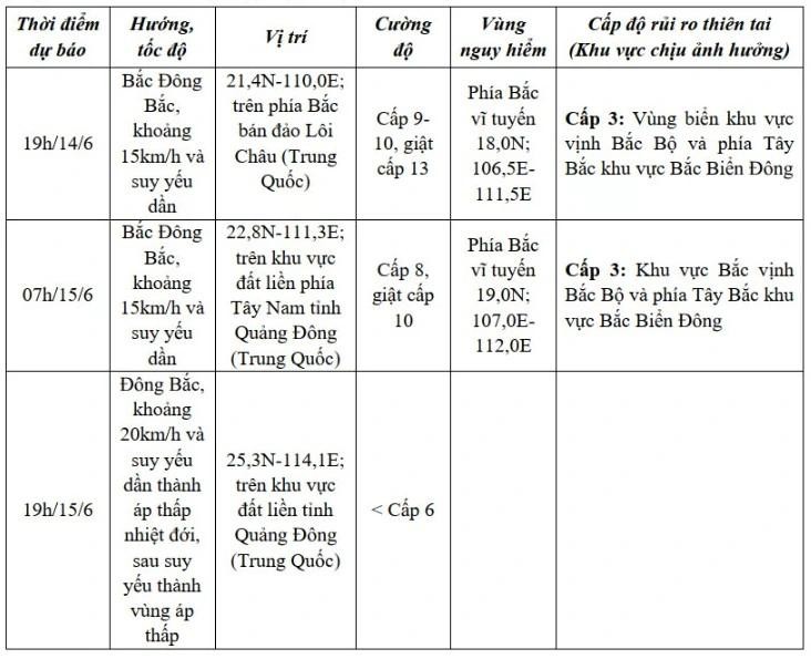
Due to strong winds and large waves at sea, the Gulf of Tonkin (including Co To and Bach Long Vi island districts) has strong winds of level 7, near the storm center of level 8-9, gusting to level 13. Waves are 2.0-4.0m high, especially in the East 3.0-5.0m. The sea is very rough.
Northwest of the North East Sea area has strong winds of level 6, gusts of level 8, waves 2.0-4.0m high. Rough seas.
Ships in danger zones are at risk of storms, whirlwinds, strong winds and large waves.
Coastal area of Quang Ninh - Hai Phong : Strong wind level 6, gust level 8.
Coastal area of Thai Binh - Nam Dinh : Strong wind level 4-5, gust level 6-7.
Source: https://baolaocai.vn/hoan-luu-bao-so-1-co-gio-manh-cap-7-giat-cap-8-tren-dao-bach-long-vi-post403290.html


Comment (0)