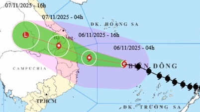
Specifically, according to Mr. Mai Van Khiem, Director of the National Center for Hydro-Meteorological Forecasting, at 11:40 a.m. on September 19, storm No. 4 was located on the coast of Quang Binh - Quang Tri with an intensity of level 8 - 9, gusting to level 11.
“It is expected that from 13:00 to 15:00 today, September 19, storm No. 4 will make landfall in the provinces of Quang Binh - Quang Tri, due to the impact of storm No. 4, the area near the center of the storm will be level 8 - 9, gusting to level 10. Strong winds from level 6 and above will be recorded from Thua Thien Hue to Ha Tinh ,” said Mr. Khiem.

Mr. Mai Van Khiem, Director of the National Center for Hydro-Meteorological Forecasting, said that around 13-15 o'clock today, September 19, storm No. 4 will make landfall in the provinces of Quang Binh - Quang Tri . Photo: nchmf.
According to Mr. Khiem, from Thua Thien Hue to Da Nang, strong winds are not too worrisome, but heavy rains will cause many impacts.
Accordingly, from September 19 to September 20, in the North Central and Central Central regions, there will be heavy to very heavy rain with common rainfall from 100-300mm, locally over 500mm.
Beware of heavy rain (>150mm/6 hours) in the area from Quang Tri to Da Nang on September 19.
On September 19, the Central Highlands and the South will have moderate rain, heavy rain and thunderstorms, locally very heavy rain with common rainfall from 20-40mm, in some places over 70mm.
Heavy rains lead to flooding in densely populated urban areas because the water cannot drain quickly.
It is known that landslides have appeared in mountainous areas of Quang Nam province, and people were urgently evacuated at night.
 ") // // .removeAttr("style"); el.find(".first").show(); el.find("a.second").html(""); el.find("a.second").removeAttr("data-out"); $('.comment-account').html(`
 ") // // .removeAttr("style"); el.find(".first").show(); el.find("a.second").html(""); el.find("a.second").attr("data-out", "0"); $('.comment-account').html(` ") // .removeAttr("style"); //el.find("a.second").html(""); }); }; fnPopupBindAction(); //login Facebook var otherLogin = { init: function() { var me = this; //gapi.load('auth2', function () { // gapi.auth2.init({ // client_id: '678720187862-08lendtdt5h3nr4j2he534p15b13aieg.apps.googleusercontent.com', // scope: 'email profile', // fetch_basic_profile: true // }); //}); $("#cmt-account-social button[data-type]").on('click', function() { me[$(this).attr("data-type")](function(response) { $("#cmt-account-header .tabs .close, #cmt-account .tabs .close") .click(); }); }); try { fbClient.appId = '1304555827613749'; //'211029740744825'; fbClient.version = "v14.0"; fbClient.init(); setTimeout(FB.AppEvents.logPageView, 5000); } catch (e) { // ignore } }, loginFacebook: function(cb) { var me = this; function reloginFacebook(callback) { FB.api('/me', { fields: 'id, name, email' }, function(profile) { //console.debug(profile); if (typeof callback === "function") callback(profile); }); }; FB.login(function(response) { if (response.authResponse) { reloginFacebook(function(info) { console.log(info); info.social = "facebook"; info.accessToken = response.authResponse.accessToken; var user = { email: info.email, name: info.name, } let now = new Date(); lgSetCookie('my_dv',JSON.stringify(user), new Date(now.getTime() + (30 * 12 * 60000))); authLogin(user.name, true); }); } else { $("#cmt_alert").html( "You have denied permission to access your Facebook account"); } }, { scope: 'public_profile,email' }); }, loginGoogle: function(callback) { var me = this; function callSocialApi(data, cb) { data.social = "google"; var user = { email: data.email, name: data.name, } let now = new Date(); lgSetCookie('my_dv',JSON.stringify(user), new Date(now.getTime() + (30 * 12 * 60000))); authLogin(user.name, true); } // API call for Google login if (gapi.auth2.getAuthInstance().isSignedIn.get()) { //console.debug('[VCC] GAPI Process'); var profile = gapi.auth2.getAuthInstance().currentUser.get().getBasicProfile(); //var id_token = gapi.auth2.getAuthInstance().currentUser.get().getAuthResponse().id_token; var access_token = gapi.auth2.getAuthInstance().currentUser.get().getAuthResponse() .access_token; var params = { id: profile.getId(), name: profile.getName(), email: profile.getEmail(), accessToken: access_token } //console.log('params: ', params); callSocialApi(params, callback); } else { //console.debug('[VCC] GAPI Login'); gapi.auth2.getAuthInstance().signIn().then( function(success) { var profile = gapi.auth2.getAuthInstance().currentUser.get() .getBasicProfile(); //var id_token = gapi.auth2.getAuthInstance().currentUser.get().getAuthResponse().id_token; var access_token = gapi.auth2.getAuthInstance().currentUser.get() .getAuthResponse().access_token; var params = { id: profile.getId(), name: profile.getName(), email: profile.getEmail(), accessToken: access_token } //console.log('params: ', params); callSocialApi(params, callback); }, function(error) { $("#cmt_alert").html( "You have refused to grant Dan Viet Newspaper permission to access your Google account" ); } ); } } } otherLogin.init(); });
Source: https://danviet.vn/hot-chuyen-gia-du-bao-thoi-diem-nao-bao-so-4-di-vao-dat-lien-cac-tinh-quang-binh-quang-tri-20240919121738708.htm


![[Photo] Opening of the 14th Conference of the 13th Party Central Committee](https://vphoto.vietnam.vn/thumb/1200x675/vietnam/resource/IMAGE/2025/11/05/1762310995216_a5-bnd-5742-5255-jpg.webp)