

Authorities of Co To special zone ( Quang Ninh ) propagate to people to bring boats to storm shelters - Photo: Dong Bac
Although the meteorological agency forecasts that super typhoon Ragasa (storm No. 9) will weaken to level 11-12 when it moves into the Gulf of Tonkin on the morning of September 25 and is likely to make landfall in Quang Ninh - Hung Yen from noon to afternoon of the same day, Prime Minister Pham Minh Chinh requested that people not be negligent or subjective.
In the telegram on storm Ragasa prevention on September 23, the Prime Minister also requested ministries, departments, branches and provinces from Ha Tinh to the North to respond to storm Ragasa with the most determined spirit, proactively respond at the highest level, anticipate the worst scenario, not be passive and surprised, and put the goal of ensuring people's safety first and foremost.
From tonight, the North, Thanh Hoa and Nghe An will have heavy rain.
According to the National Center for Hydro-Meteorological Forecasting, as of 6 p.m. on September 23, super typhoon Ragasa was about 640 km east of Leizhou Peninsula (China); the strongest wind near the storm's center was level 16 (184 - 201 km/h), gusting to level 17.
The Vietnam Meteorological Agency said that by the afternoon of September 23, the forecasts of international and Vietnamese storm forecasting centers were in high agreement on the direction of Ragasa storm. Around noon to the afternoon of September 25, the eye of the storm will make landfall in our country, and the area from Quang Ninh to Hung Yen is the area with a high possibility of the eye of the storm making landfall.
Meanwhile, the Japanese and Chinese meteorological agencies said that the storm will affect Vietnam in the afternoon and evening of September 25, focusing on the Quang Ninh - Hai Phong area, with a level 9 intensity and gusts of level 12. Hong Kong Radio said that the storm will affect Vietnam in the morning of September 25, focusing on the Quang Ninh area, with a level 11 intensity and gusts of level 14. The US forecast said that the storm will affect Vietnam in the morning and afternoon of September 25, focusing on the Quang Ninh area, with a level 10 intensity and gusts of level 12.
Regarding the impact of storm Ragasa (forecast at 5:00 p.m. on September 23), from early morning on September 25, coastal areas from Quang Ninh to Ninh Binh will have winds gradually increasing to level 6 - 7, areas near the storm center will have winds of level 8 - 9, gusting to level 11. Inland areas in the Northeast will have strong winds of level 5, in some places level 6, gusting to level 7 - 8.
Heavy rains will be concentrated in Thai Nguyen, southern Tuyen Quang, Lao Cai, Phu Tho, the Northern Delta, and Thanh Hoa. On September 25, rain will be concentrated in Cao Bang, Thai Nguyen, Lang Son, Quang Ninh, Hai Phong, Bac Ninh, and Hung Yen. On September 26 and 27, heavy rains will occur in Phu Tho, the Northern Delta, and Thanh Hoa. Heavy rains concentrated in a short period of time pose a special risk of flash floods and landslides, concentrated in the mountainous and midland areas of the North, Thanh Hoa, and Nghe An from September 25 to 27.

Boats were brought to Ngoc Hai fishing port, Do Son (Hai Phong) to avoid the storm - Photo: Tien Nguyen
Hai Phong: Top priority for storm prevention
Hai Phong and Quang Ninh localities are focusing on preventing Ragasa storm, ensuring the safety of people's lives and property when the storm arrives.
According to the Hai Phong City Civil Defense Command, as of September 23, units and localities in the city have coordinated to count and notify 1,604 vehicles/4,481 workers, 271 rafts/233 workers operating and anchored to know the storm's developments so that they can proactively take precautions.
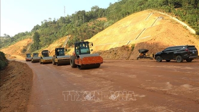
The work of evacuating and ensuring safety for tourists in Cat Hai special zone, Do Son ward was carried out promptly. Critical locations of dykes, embankments, culverts, dams, degraded apartment buildings, low-lying areas, bridges, warehouses, factories... were inspected, reviewed and specific prevention plans were developed.
Hai Phong City Party Secretary Le Tien Chau said the city is focusing on organizing the City Party Congress for the 2025-2030 term. However, the task of preventing storm Ragasa must not be subjective, negligent, or lose vigilance and must be given top priority.
According to the Secretary of the Hai Phong City Party Committee, local authorities and functional agencies need to grasp and have timely response measures according to the "4 on-site" motto, minimizing damage caused by storms and their impacts on Hai Phong.
Mr. Dao Minh Dong, Chairman of the People's Committee of Bach Long Vi Special Zone, said that as of September 23, the special zone had called on 198 boats to take shelter from the storm. At the same time, it was preparing a plan to evacuate households in vulnerable areas to shelter from the storm at the multi-purpose gymnasium and was ready to implement a plan to protect livestock and crops to ensure safety.
According to Tuoi Tre newspaper, in Cat Ba special zone, Do Son ward... the "head of the storm", storm prevention work is being urgently deployed.

Forecast of the location and direction of storm Ragasa Source: nchmf - Graphics: TAN DAT
Quang Ninh: ensuring people's lives and property
Mr. Bui Van Khang, Chairman of the People's Committee of Quang Ninh province, said that the province has synchronously deployed response solutions with a drastic spirit, early and from afar, with the goal of absolutely not allowing human casualties and minimizing property damage.
As of September 23, more than 4,100 fishing boats and nearly 500 tourist boats had received information and moved to safe anchorages. 7,900 aquaculture facilities, including 800 at sea, had reinforced and relocated workers ashore. Large reservoirs in the area were proactively lowered to prevent floods; dyke works, landslide and inundation prevention, tree trimming, reinforcement of high-rise buildings, telecommunication poles, etc. were vigorously implemented.
More than 3,000 officers and soldiers along with hundreds of vehicles have been mobilized, ready for rescue missions. Localities in the province are continuing to promote information, resolutely evacuate people in dangerous areas, increase patrols of reservoirs and proactively take all measures to ensure the safety of people's lives and property from the impact of the storm.
According to Mr. Nguyen Sinh Luong - Vice Chairman of the People's Committee of Van Don Special Economic Zone, as of September 23, all fishing boats in the special economic zone have been contacted and informed in a timely manner about the location and direction of storm Ragasa and have moved to a safe anchorage.
The leaders of Mong Cai 2 ward also said that they had directly inspected residential areas, boat mooring areas and the construction area of the road project to Van Ninh port, and directed the construction unit to strictly implement plans to protect works and equipment, ensuring safety for workers.
"No storm is gentle"
On September 23, Deputy Prime Minister Tran Hong Ha chaired a meeting in person and online with relevant units on response plans for super typhoon Ragasa.
Deputy Minister of Agriculture and Environment Nguyen Hoang Hiep noted that although the storm has weakened in strength when it makes landfall, it is still active at sea, so it is necessary to be on the highest alert, limit ships going out to sea, and protect aquaculture areas.
When the storm hits the shore, it will combine with cold air to cause many dangerous thunderstorms on September 25 and 26, which cannot be accurately predicted. Many reservoirs in the North are full of water due to the end of the season accumulation, so localities must be "on duty" to monitor and operate the reservoirs safely.
In particular, large lakes such as Thac Ba, Son La, Hoa Binh, Tuyen Quang are near normal water level, high risk of flooding. Pay attention to the dyke system at river mouths, high tide areas, harvest rice early.
Emphasizing the principle of storm response that "no storm is mild", Deputy Prime Minister Tran Hong Ha said that each storm is accompanied by many abnormal factors and impacts before, during and after making landfall. Storm Ragasa is considered a "super storm" at sea, so timely issuance of warning bulletins and dispatches by competent agencies is necessary.
Therefore, localities tighten the "4 on-site" mechanism, especially ensuring electricity, gasoline, and communications, and even having to prepare generators and backup vehicles to maintain operations when incidents occur.
It is especially important to note that although the storm has been downgraded, Ragasa still has the potential to cause tornadoes, heavy rains, and safety risks. Therefore, meteorological agencies must increase forecasts with images and easy-to-understand warning information so that people can clearly understand and proactively prevent it.
East Sea likely to welcome storm No. 10 right after storm Ragasa
The National Center for Hydro-Meteorological Forecasting said that a tropical depression has just appeared in the eastern region of the Philippines. It is forecasted that on September 24, the tropical depression will likely strengthen into a storm and on September 27, this storm will likely move into the East Sea and become storm number 10.
Currently, European and Japanese forecasts predict that storm No. 10 will move north, towards the North or the southern region of China. However, the US forecast predicts that the storm will move into the Central region (focusing on the provinces from Ha Tinh to Quang Ngai).
Vietnam Meteorological Forecasting: The possibility of a storm moving into the Central region is the scenario with the highest probability because during this period, according to the climate law, the storm will move into the Central region. The possibility of strengthening to a super storm or a storm stronger than level 13 is not high.
Countries are working together to cope
Philippines: According to the Bangkok Post, on September 23, in the Philippines, super typhoon Ragasa - also known as Nando - devastated the Philippines. This is the strongest super typhoon recorded in 2025, causing dangerous high waves, widespread power outages and forcing thousands of people to evacuate.
According to the Philippine Disaster Management Agency, at least two people were killed, nine injured and about 10,000 people were forced to flee their homes. The transportation system in the northern Philippines was cut off, many roads were eroded, and houses were severely damaged.
The extent of damage in the Babuyan archipelago is still unknown, while the Philippine weather agency warned of "life-threatening" risks from continued flash floods and landslides.
China: The country has raised the emergency alert level and deployed a variety of response measures in more than 11 cities and localities as the typhoon is approaching the coast of Guangdong. According to Reuters on September 23, the Guangdong Emergency Management Bureau said that typhoon Ragasa is expected to make landfall in the central and western coastal areas of the province in the next 24 hours with waves up to 7 meters high.
Schools, offices and public transport across Guangdong were shut down. In Shenzhen, authorities set up more than 800 emergency shelters, cut down large trees and ordered the evacuation of 400,000 residents in low-lying and coastal areas.
In Hong Kong , 46 emergency shelters were opened. All schools and businesses were closed, while most commercial flights were canceled from September 23 to 25.
The meteorological department warned of a huge storm surge: 2 meters along the coast and reaching 4-5 meters in some areas, similar to the super typhoons Hato (2017) and Mangkhut (2018), which caused billions of dollars in damage. Hong Kong authorities distributed sandbags to low-lying residents to reinforce their homes, while people rushed to stock up on food.
Other major regions including Macau, Zhuhai, Dongguan and Foshan have also imposed school and business closures. In Taiwan, authorities issued warnings on both land and sea, canceled 273 flights, halted all ferry and rail services, and evacuated more than 7,600 people in the mountainous south and east. Heavy rains have injured 25 people due to landslides and strong winds.
Thailand : Although not in the storm's direct path, Thailand was heavily affected by the Ragasa circulation combined with the southwest monsoon. The Thai Department of Disaster Prevention and Mitigation said that on the morning of September 23, flooding had been recorded in 16 provinces.
Authorities warned people to be on guard against flash floods, landslides, and inundation in low-lying areas, along rivers, and in the foothills. Thailand also warned of rough seas: waves 2-3m high in the North Andaman Sea, which could exceed 3m during thunderstorms; waves 1-2m high in the Gulf of Thailand and the South Andaman Sea. The country's Meteorological Department advised small boats not to set sail from September 24 to 26.
Source: https://tuoitre.vn/khong-chu-quan-voi-bao-ragasa-20250924075546392.htm


![Dong Nai OCOP transition: [Part 2] Opening new distribution channel](https://vphoto.vietnam.vn/thumb/402x226/vietnam/resource/IMAGE/2025/11/09/1762655780766_4613-anh-1_20240803100041-nongnghiep-154608.jpeg)


Comment (0)