

On the night of October 31 and November 1, cold air continued to strengthen, expanding its influence to other places in the North Central and Northwest regions, then affecting the Central Central region. On land, the Northeast wind was strong at level 2-3, and in coastal areas at level 3. Due to the influence of cold air combined with disturbances in the East wind zone, there was rain in many places in the North, Thanh Hoa and Northern Nghe An .
In the North and North Central regions, the weather is cold, in the mountainous areas of the North, it is cold in some places. The lowest temperature in this cold air mass is generally from 18-21 degrees Celsius, in the mountainous areas of the North, it is below 17 degrees Celsius in some places.
Hanoi area has rain, cold weather. The lowest temperature in this cold air mass is commonly 19-21 degrees Celsius.
At sea: In the Gulf of Tonkin, the sea area from South Quang Tri to Quang Ngai has strong northeast wind level 5, sometimes level 6, gusting to level 7-8, rough sea, waves 1.5-3m high; the North East Sea area (including Hoang Sa special zone) has strong northeast wind level 6, gusting to level 7-8, rough sea, waves 2-4m high.
Due to the influence of cold air strengthening combined with disturbances in the upper easterly wind zone, the area from South Nghe An to Quang Ngai has heavy to very heavy rain and thunderstorms.
Specifically, from the evening of October 31 to November 2, the area from Ha Tinh to Da Nang will have heavy to very heavy rain with common rainfall of 200 - 400mm, locally over 700mm; the area of Southern Nghe An and Quang Ngai will have heavy rain with common rainfall of 100 - 200mm, locally over 300mm. Warning of the risk of heavy rain (over 150mm/3 hours).
In addition, in the evening and night of October 31, in the area from Gia Lai to Lam Dong and the South, there will be scattered showers and thunderstorms with rainfall of 15-30mm, with some places experiencing heavy rain over 70mm. During thunderstorms, there is a possibility of tornadoes, lightning, hail and strong gusts of wind. Warning of the risk of heavy rain (over 70mm/3 hours).
Warning: On the night of November 2 and on November 3, the area from Southern Nghe An to Quang Ngai will have heavy to very heavy rain with common rainfall of 100 - 200mm, locally over 350mm. Heavy rain in the Central region is likely to last until around the night of November 4.
Warning level of natural disaster risk due to heavy rain, tornadoes, lightning, hail: level 1; level 2 for areas from Ha Tinh to Da Nang.
Floods on many rivers
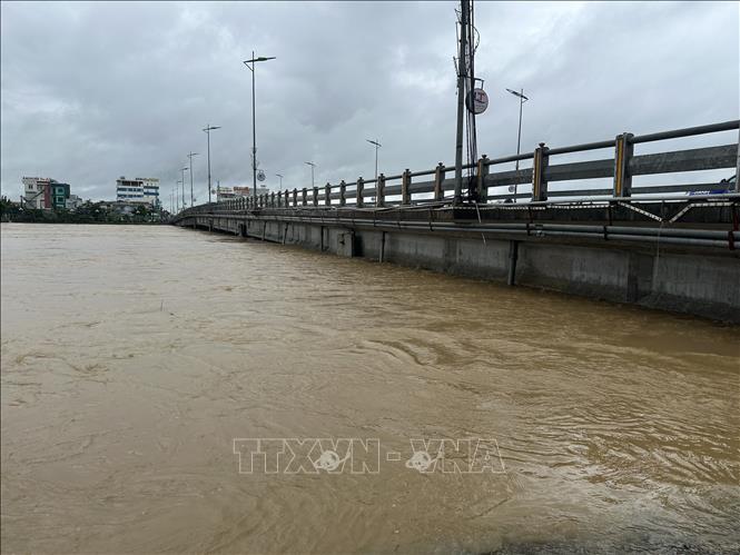
Currently, floods on rivers from Hue city to Da Nang are receding, especially floods on Huong river (Hue city) are fluctuating above alert level 2. Water levels at 1:00 p.m. on October 31, 2025 on rivers are as follows: On Bo river (Hue) at Phu Oc station 3.11m, above alert level 2 by 0.11m; on Huong river (Hue) at Kim Long station 2.31m, above alert level 2 by 0.31m; on Vu Gia river (Da Nang) at Ai Nghia station 7.97m, below alert level 2 by 0.03m; on Thu Bon river (Da Nang city) at Cau Lau station 3.06m, above alert level 2 by 0.06m.
It is forecasted that in the next 24 hours, flood on Huong River will continue to fluctuate above alert level 2; flood on Bo River will drop below alert level 2, on Vu Gia and Thu Bon Rivers will drop to alert level 1 and above alert level 1.
Warning: From today (October 31) to November 5, there is a possibility of a flood on rivers from Nghe An to Ha Tinh; floods on rivers from Quang Tri to Da Nang city are likely to rise again. During this flood, the peak water level of the upstream Ca River (Nghe An) will rise above alert level 1; Ngan Sau and Ngan Pho rivers (Ha Tinh), Gianh River, Kien Giang River, Thach Han River (Quang Tri) will rise to alert levels 2-3, some rivers will be above alert level 3, the downstream La River (Ha Tinh) will rise to alert levels 1-2; rivers in Hue city and Da Nang city will be from below alert level 2 to above alert level 2.
The situation of deep and widespread flooding in Da Nang city is gradually decreasing, flooding in Hue city will continue to decrease rapidly in the next 1-2 days; risk of flooding in low-lying areas along rivers, urban areas, and residential areas in provinces from Nghe An to Quang Tri. High risk of flash floods on rivers and streams and landslides on slopes in provinces/cities from Nghe An to Da Nang. Warning level of natural disaster risk due to floods: Level 2.
Specific weather in each region on the night of November 31 and November 1

Northwest has rain. Northeast wind level 2-3. Cold weather, some places are freezing. Lowest temperature from 18-21 degrees Celsius, some places below 17 degrees Celsius; highest from 23-26 degrees Celsius, some places above 26 degrees Celsius.
There is also rain in the Northeast. Northeast wind level 2-3, coastal areas level 3. Cold weather, some mountainous areas are cold. Lowest temperature from 18-21 degrees Celsius, some mountainous areas below 17 degrees Celsius; highest from 21-24 degrees Celsius.
From Thanh Hoa to Hue, there will be heavy rain, locally very heavy rain and thunderstorms. North to Northwest wind level 2-3, cold in the North. During thunderstorms, there is a possibility of tornadoes, lightning and strong gusts of wind. Lowest temperature from 21-24 degrees Celsius; highest from 24-27 degrees Celsius.
In the South Central Coast region, the North is cloudy with heavy rain, locally very heavy rain and thunderstorms; the South is cloudy with scattered showers and thunderstorms, locally heavy rain. East to Northeast wind level 2-3. During thunderstorms, there is a possibility of tornadoes, lightning and strong gusts of wind. The lowest temperature is from 23-26 degrees Celsius; the highest in the North is from 26-29 degrees Celsius, in the South is from 29-32 degrees Celsius.
The Central Highlands has scattered showers and thunderstorms, with some areas experiencing heavy rain. Thunderstorms may include tornadoes, lightning, hail, and strong gusts of wind. The lowest temperature ranges from 18–21 degrees Celsius, with some places below 18 degrees Celsius; the highest ranges from 26–29 degrees Celsius.
The South has scattered showers and thunderstorms, with some heavy rain in some places. West to Southwest wind level 2-3. During thunderstorms, there is a possibility of tornadoes, lightning, hail and strong gusts of wind. Lowest temperature from 23-26 degrees Celsius; highest from 29-32 degrees Celsius.
Hanoi has rain. Northeast wind level 2-3, cold weather. Lowest temperature from 19-21 degrees Celsius; highest from 21-23 degrees Celsius.
Ho Chi Minh City also has scattered showers and thunderstorms, with some places having heavy rain. West to Southwest wind level 2-3. During thunderstorms, there is a possibility of tornadoes, lightning, hail and strong gusts of wind. The lowest temperature is from 24-26 degrees Celsius; the highest is from 30-32 degrees Celsius.
Source: https://baotintuc.vn/van-de-quan-tam/lu-tren-cac-song-tu-quang-tri-den-da-nang-co-kha-nang-len-lai-20251031171255972.htm


![[Photo] Da Nang: Water gradually recedes, local authorities take advantage of the cleanup](https://vphoto.vietnam.vn/thumb/1200x675/vietnam/resource/IMAGE/2025/10/31/1761897188943_ndo_tr_2-jpg.webp)

![[Photo] Prime Minister Pham Minh Chinh attends the 5th National Press Awards Ceremony on preventing and combating corruption, waste and negativity](https://vphoto.vietnam.vn/thumb/1200x675/vietnam/resource/IMAGE/2025/10/31/1761881588160_dsc-8359-jpg.webp)


Comment (0)